
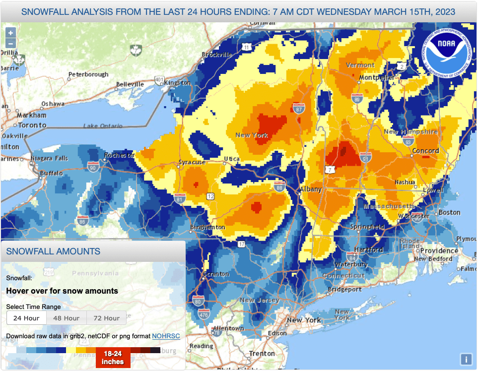
Can there ever be too much of a good thing? Yes, if it prevents people from getting out safely and grooming the trails. Western Massachusetts and southern Vermont got anywhere from 18″ to over 3 feet of snow!
The best part of all the snow is that the nearest areas are now open for skiing, with very good to excellent conditions. Fahnestock, Minnewaska, Mohonk, and High Point are all open.
Aside from these next few days being a great time to be retired or a gig worker who can set their work ties, there’s a very good chance the downstate snowpack will hold through the weekend.
This post is about conditions for March 15 2023, and forecast for the next few days. See jump links to Conditions and Forecast.
High Point gets the photo of the day:

Graphic of snowfall totals, with some screaming read areas of 24″:
Conditions
In the southern and low-lying areas, the snowfall was heavy and wet. At higher elevations and more northerly, a period of dry snow followed wet, making for an interesting layer-cake that seems tough to groom. the amount of snow and blustery winds later also caused a lot of debris and some power outages.
All that is to say the conditions are good once the people doing the clean-up and grooming can dig themselves out and get to it. The trails will be spring skiing conditions- firm and a bit icy in mornings, damp and softer in the afternoons. Some areas are TBD or ‘pending’ as a result.
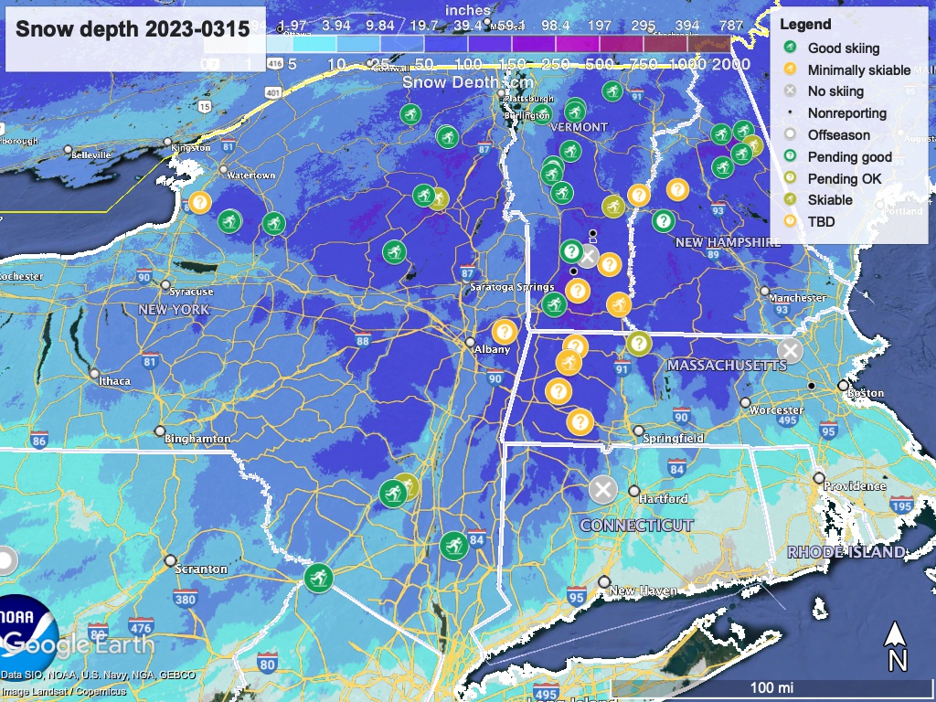
Hit up ‘State of the touring centers‘ or in the menu above for reported conditions as of today. Snow depth graphic below:
Forecast
Friday morning the northeast will start seeing rain, even in the north country. Little total rainfall expected- good news for the snowpack. Possible snow showers at higher elevations. Showers will abate on Saturday morning,
Cooler temperatures will likely bring some lake effect snow across the Tug Hill, Adirondacks, and far northern Vermont on Saturday night and Sunday. There could be blustery conditions in the second half of the weekend.
A midweek system will enter downstate NY and southern New England on Wednesday, brining a mix of light rain and possibly some wintry mix or snow.
Nighttime temperatures will stay below freezing in the northern areas, with the exception of the Friday-Saturday overnight. The downstate region will stay above freezing through most of this weekend and toward the end of next week.
| Daytime temps | Thursday 3/16 | Friday 3/17 | Saturday 3/18 | Sunday 3/19 | Monday 3/20 | Tuesday 3/21 | Wednesday 3/22 |
| Northern NY, VT, NH | Mid-30s to low-40s | Mid-40s to mid-40s | Upper-20s to low-40s | Teens to low-30s | Mid-20s to low-40s | 30s to low-40s | 30s to low-40s |
| NYC metro and coastal New England | 50s | Upper-50s | Upper-40s to low-50s | Upper-30s to low-40s | Mid- to upper-40s | Upper-40s to low-50s | Upper-40s to low-50ss |
