
A major winter storm arrives early in the week, while another is due on Friday that could bring rain. Nights up north will be close to or below freezing, through Thursday and daytimes will be very springlike. Carpe ski’em- do it whenever you can.
This post is about conditions for March 12, 2023, and forecast for the next few days. See jump links to Conditions and Forecast.
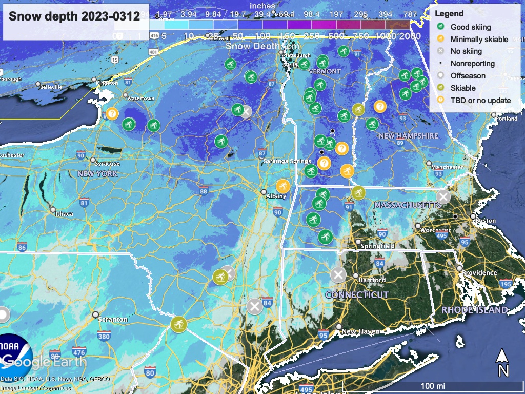
Conditions
Similar to the end of last week, snow is frozen granular in the mornings, softening to wet, loose granular in the afternoons. The downstate areas that got snow have excellent conditions, but it won’t last for long due to the temperatures expected. Hope you got some skiing in.
Hit up ‘State of the touring centers‘ or in the menu above for reported conditions as of today. Snow depth graphic below:
Forecast
Significant winter storm will arrive in the northeast on Tuesday, lasting through Wednesday. Better than 50% chance of 4″ of snow in the downstate region, and much more across centra and northern New York (including the Catskills and southern Adirondacks), southern Vermont and western Massachusetts, and New Hampshire. Elevated areas could get 12-24″”, while much lower accumulations are forecast for the valleys.
What Mother Nature gives with one hand, she takes with another- later in the week another system is likely to bring rain across the region starting Friday morning. Rain could change over to snow during the Friday-Saturday overnight. Warmer daytime and nighttime temperatures accompany this system, portending negative change to the state of the snowpack.
On the hopeful side, there’s time for the late week forecast to change.

| Daytime temps | Monday 3/13 | Tuesday 3/14 | Wednesday 3/15 | Thursday 3/16 | Friday 3/17 | Saturday 3/18 |
| Northern NY, VT, NH | Mid-20s to low-40s | Low-20s to mid-30s | Mid-20s to mid-30s | Mid-30s to mid-40s | Mid-30s to mid-40s | 30s to low-40s |
| NYC metro and coastal New England | Upper-30s to mid-40s | Mid- to uppser-30s | Upper-30s to mid-40s | Upper-40s to mid-50s | Low- to mid-50s | Upper-40s to mid-40s |
