Red sky at morning, sailor take warning
image via Prospect Mountain VT
This post contains section links to Conditions and Forecast.
Summary
The north country will get a nearly all-snow event this week, while downstaters will be hoping enough cover survives the rain to hold onto XC skiing within a four hour drive of the city. Depending on whether Mother Nature shows mercy and when the cold weather comes back, maintenance crews will be attaching the Ginzu groomers either Friday evening or Saturday morning.
Best days to ski: for anyone in the far north of the region, Saturday or Sunday. In the Catskills, Berkshires, southern VT or the White Mountains, Saturday will likely be a day to regroup and regroom, so Sunday looks best. Everyone else has to hope for the best that there’s groomable cover for the weekend, and a chance to ski on Sunday.
Current conditions
BETA report as of 1/31 is predicting a bit of rain for the High Peaks Wednesday night but transitioning to snow and good winter weather for the weekend.
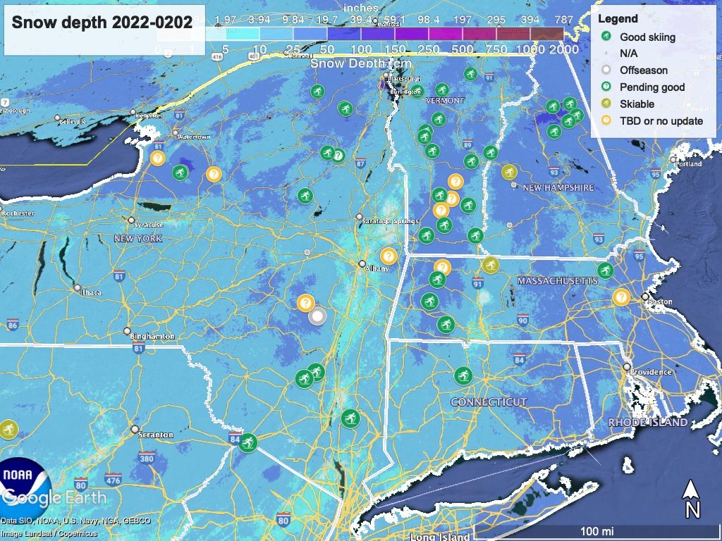
Hit up ‘State of the touring centers‘ or in the menu above for reported conditions as of today. Snow depth graphic below:
Forecast
Wednesday is our last nice day till Saturday. Weather systems will begin mixing it up in the early evening with scattered precipitation of varying types across the region. Given the warm temps, we’re in for the classic northeast winter reversal in the NYC metro area: what Mother Nature giveth, she then melts away.
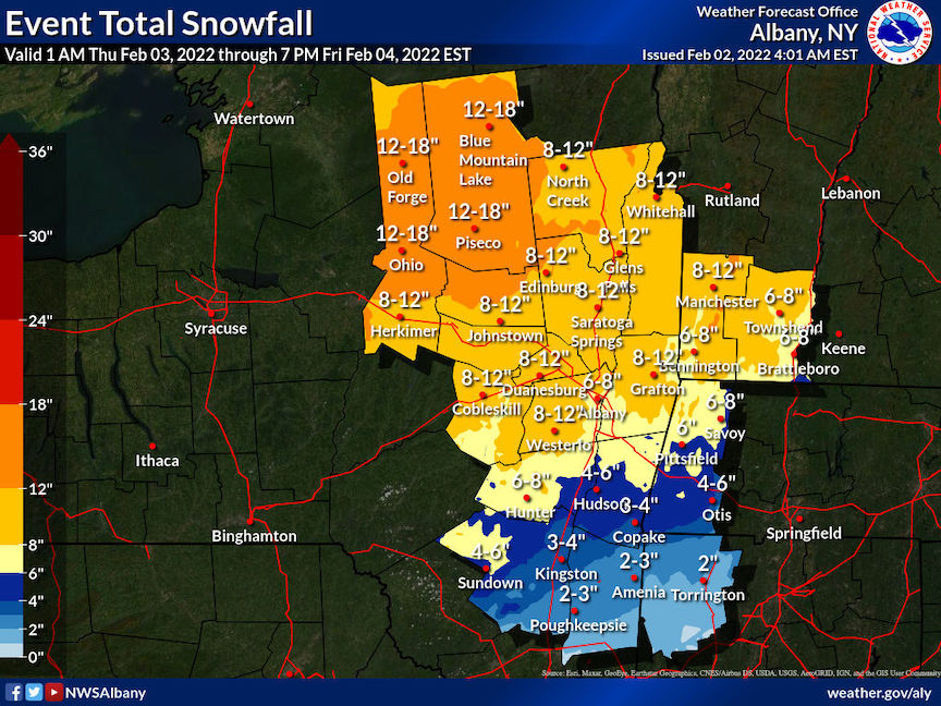
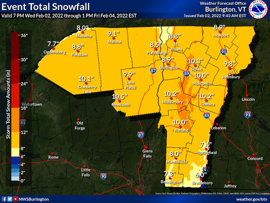
Two systems, one from the west and another from southeast, will create significant storms over the northeast starting Wednesday night. The precipitation will start in the west with scattered rain, snow, and wintry mix and overspread the region. On Thursday precipitation types will separate across a line running southwest-northeast, roughly following Interstate 88 from Binghamton to the Albany-Saranac Lake area, and on to the White Mountains in NH. North of the line precipitation will be mostly snow; to the south, mostly rain. For the areas closest to that dividing line: ice and wintry mix.
Thursday will be the warmest day of the week for us downstate, reaching the mid-40s. Up north however, things will be cooler than Wednesday, reaching the mid- to upper-30s, except in the far north and west where mid-20s are possible. This storm is not for us downstaters- in the far north, there will be snow all day Thursday and most of the day Friday.
Friday freeze warning
Friday temps downstate will start out in the 30s-40s, but much cooler upstate- teens to 20s. As the system from the west moves out it will be followed by cold air from the north, moving the rain-vs-snow dividing line southward. As a result, temperatures are expected to drop rapidly below freezing from the Albany region toward NYC. Rain will change over to sleet or wintry mix; in addition the rains and snowmelt from Thursday could cause localized flooding.
In short: objective hazards are likely on Friday due to meltwater, freezing rain, and drop in temperature. Take care when outdoors in the zone from Binghamton to Albany, the Berkshires and southern VT/NH, and areas further south. Driving could be dicey in parts.
The weekend and early next week
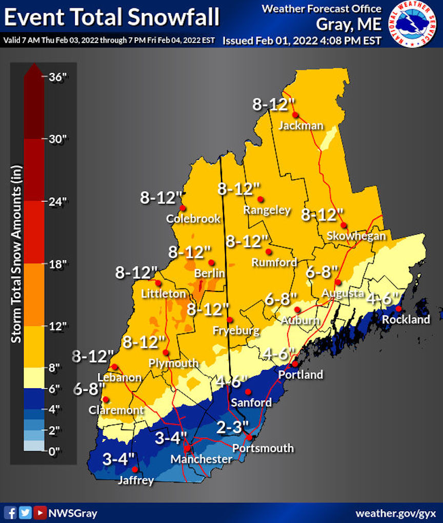
The lucky ducks will be those skiers in the north country: When all is said and done, a swath of the northeast extending from the Finger Lakes of NY through the Adirondacks and northern Green Mountains to northern NH and Maine could get 8-12″ of snow, and over a foot in higher elevations and the Tug Hill. They’ll also enjoy nice and wintry temps through the early part of next week.
Downstate NY and southern New England will get rain, and some wintry mix/ice toward the end of the storm. We’ll be lucky if there’s any snowpack left on Saturday. Along a band from northern PA across the Catskills and across northwest Massachusetts, the precipitation will be rain, ice, and some snow. Elevated areas (ie, the Catskills, Berkshires, Shawangunks) might just be lucky enough to avoid the worst of the rain.
Saturday will be the coolest day of the week, and dry. Temps downstate will be in the mid-20s to low 30s. Temps in the north country will be in the high single digits to teens.
Sunday should also be dry and a bit warmer than Saturday- low 30s downstate, and teens to 20s up north. Some lake effect snow possible for the Tug Hill area Sunday evening into Monday.
The early part of next week will be dry and a touch warmer: mid- to upper-30s downstate, and 20s to low 30s in the north. The 6-10 day outlook from NWS is ‘leaning’ cooler and drier than normal.
Groundhog Day
And it’s that day of the year- again. Thanks for reading.