
This post contains section links to Conditions and Forecast.
Summary
Mid-Atlantic and New England coastal areas got slammed; inland, not so much. But it’s enough to keep us skiing for at least till warm weather and rain arrive during the week.
For now, downstate skiers rejoice- All the local touring centers got a refresh of snow, making for good conditions, and if you were lucky enough to have more than 8″ fall on the ground, you can ski on a local golf course or park trail.
Fahnestock, High Point, Minnewaska, and Mohonk all report good conditions. Winding Trails in Connecticut is skiable. The Berkshires and western MA did well, and Canterbury Inn, Maple Corner Farm, and Notchview all report good conditions.
Conditions
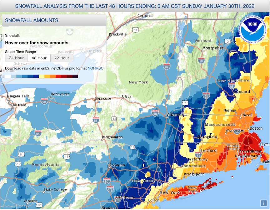
We got the storm we needed to refresh the base, even though it left areas a bit north of NYC and west of the Hudson out of the action. Elevated areas that caught the nor-easter winds and snow, like the Berkshires, southern tip of the Green Mountains, and the White Mountains got a good refresh as well.
Snowfall amounts captured in the two screenshots below. Darkest red-brown (east end of Long Island and the area south of Boston): 24-30″. Colors grade progressively smaller depth ranges: red: 18-24″; orange-yellow: 12-18″; yellow: 8-12″; pale yellow: 6-8″; dark blue: 4-6″; and so on.

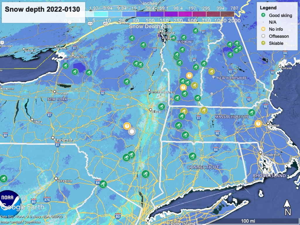
Hit up ‘State of the touring centers‘ or in the menu above for reported conditions as of today. Snow depth graphic below:
Forecast
For the first few days in the week, the weather will be very nice. Dry and sunny, and trending warmer. Monday high temps will be in the low- to mid-30s downstate, and low- to mid-20s up north. Tuesday the downstate temps will go to the mid-30s, while up north it will be from the 20s to low-30s.
Wednesday the entire northeast gets above freezing- from the mid-30s to low-40s in the north country, and the mid-40s in the NYC metro. Winds from the south and southeast will meet colder air from north and west, resulting in a moderate chance of precipitation Wednesday night, during which we can expect some rain in the south, with snow and wintry mix north of Albany and the MA-VT/NH border.
On Thursday precipitation is very likely, and temperature gradients will drive the demarcation lines of snow, wintry mix, and rain. Temps for Thursday will continue to be in the mid-40s for the downstate and southern New England region, but the north country will be a bit cooler, reaching the mid-30s. Get ready for a pretty messy day in parts of the northeast.
For Friday, downstate NY and southern New England remain warm, but high temps for elevated areas north of Albany and the MA-VT/NH border will go below freezing again. Chances of precipitation once again, but this time more will fall as snow, as the winds from the north begin to dominate our weather.
The winds from the north and northwest finally drive daytime temps downstate below freezing on Saturday, and the north country will see temps in the single digits to the teens. The winds also drive out the remaining precipitation, so if there’s anything left, it’ll be time for touring centers to get out the Ginzu groomers and get to work chipping away at the frozen cover.
Have you cleaned the house, settled old debts, and bought new clothes? Year of the Tiger starts Tuesday. Thanks for reading.
