
This post contains section links to Conditions and Forecast.
Summary
Time for downstaters to ski- Bluebird day Saturday, with moderate temps Sunday and partly cloudy skies. ALL the day-trip areas will be open!
Fahnestock will have skiing starting Saturday on about 70% of trails including the lake. Other downstate areas (High Point, Minnewaska, Mohonk) have good conditions.
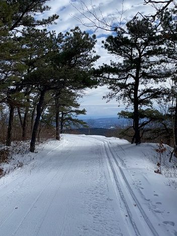
Today’s pic is of Minnewaska trails on Thursday, via the Mid Hudson Valley Cross Country Ski Google group. This group is handy for Nordic skiers in the Hudson Valley/Hudson Highlands. In addition to remarks from skiers, Minnewaska State Park posts updates to grooming and trail status when they have something to report.
Conditions
BETA report hasn’t been updated since the 18th, so I’m guessing they’re all too busy skiing.
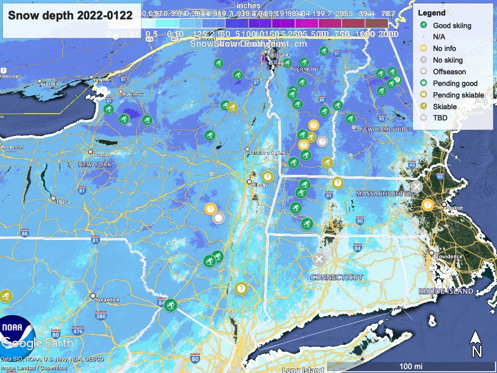
Hit up ‘State of the touring centers‘ in the menu above for reported conditions as of today. Snow depth graphic below. There’s some ‘?’ markers due to various conditions in reports or statuses. See details for each area for further info.
Forecast

This weekend will be dry and trending warmer than Friday: on Saturday, expect mid- to upper-20s downstate and teens up north. For Sunday, upper-20s to mid-30s in downstate, teens to mid-20s up north. Slight chance of snow in far northern NY and VT, and lake effect snow likely for the Tug Hill region Saturday night and Sunday. Winds will be light in partly to mostly cloudy skies on Sunday.
It adds up to some of the best weather you can ask for, and timed just right for the weekend.
While daytime temperatures for much of the next week will be wintry enough to hang onto the snowpack (mid-20s to low 30s downstate and northern areas in single digits to teens), Tuesday the temps will pop up to the low 40s downstate 20s-low 30s up north. This one-day jump in temperature will coincide with a storm front that will drop some snow up north, while the NYC metro region can expect a mix of snow and rain depending on time of day.
By Wednesday the front will be moving on and temperatures will drop back to a (dare I say it?) normal mid-winter range under partly cloudy skies.
Overall the next seven days look to be near-ideal winter weather for the roaming XC skier: cold temps, light winds, and possible snow showers but no major storms. The 6-10 day guidance from NWS Climate Prediction Center is for temps ‘likely’ below normal, and precipitation ‘leaning’ below normal, meaning we will probably have cool, dry-ish weather through next week.
Thanks for reading- get out skiing!
