
This post contains section links to Conditions and Forecast.
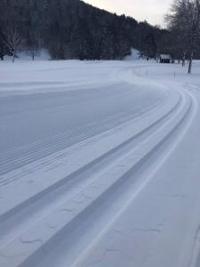
Todays pic comes from Woodstock Inn Nordic Center.
Summary
After a two week dry spell this month, Winter weather delivered some really nice cover and XC skiing is now available with good conditions almost everywhere. Most importantly for downstaters: High Point in New Jersey, Minnewaska and Mohonk in the Hudson Highlands have opened trails for skiing and are in easy day trip distance. Added plus for regular-employment people: weather for the week is looking favorable for a nicely skiable weekend.
IMHO, best ski day after taking everything into account: Sunday. Where: everywhere!
Conditions
BETA report as of 1/17 says 4-5″ of new snow, but additional accumulation would have occurred overnight. After a day of settling, trails should be good. Snow depth and trail conditions at touring centers (see below) shows dramatic improvement.
Snowfall totals for the weekend in the graphic below. (Dark orange indicates 12-18″, yellow for 8-12″, pale yellow 6-8″, dark blue 4-6″, and so on).

Hit up ‘State of the touring centers‘ or in the menu above for reported conditions as of today. Snow depth graphic below. Several areas allowed wet snow to settle and drain yesterday before grooming today, accounting for some icons indicating ‘pending’ statuses.

Forecast
Tonight and tomorrow (Wednesday), precipitation possible in the north country. Wednesday high temps will nudge above freezing across much of New York and Vermont, with temps downstate in the mid-40s. On Wednesday evening, precipitation likely in downstate and western NY, while temperatures start to drop. The western and NYC metro parts of the state will probably get rain that could change over to snow overnight and into Thursday if precipitation continues. Not a lot of accumulation expected.
Between now and Thursday, winds will shift from west-northwest to southwesterly, finally turning to come from northwest, bringing cold air into the region. Winds 10-20mph, with gusts of 25-30mph before dying down Thursday night.
Temperatures become more wintry through the end of this week and into the weekend- on Friday downstate and coastal regions will see daytime temp hit the low to mid-20s while high temps will be in the single digits in the north country.
Otherwise, the NYC metro will have high temps in the 30-35 range through the weekend, while the northern areas will have temps in the teens and 20s. Slight chance of snow showers across parts of the northeast starting Saturday afternoon.
