

This post contains section links to Conditions and Forecast.
Summary
Downstaters have now had four weeks of skiable conditions at the closest areas with groomed trails: Fahnestock, Minnewaska, Mohonk, and High Point.
Today (Tuesday) the continuing gusty winds and icy crust have caused a number of touring centers to close trails for clean-up and grooming. Backcountry and off-piste skiing may need to wait till at least tomorrow afternoon for the cover to loosen up a bit.
Freeze-thaw cycles during the week, with a little help from grooming or skiing through to break up the chunks, will keep conditions in decent shape. If there’s enough snow, there should be some nice days of skiing coming up!
During the week, only central NY and the far north country have any chance of precipitation. But if a location you like has a decent snowpack as of today, the parts that aren’t too exposed to sun should keep some kind of skiable conditions through the weekend.
Advice is: ski what you’ve got, when you can. It’ll be crusty and fast in the mornings, less so as the day goes on.
Conditions
Corn snow and frozen granular for most, but some areas will get light snow showers.
Due to the extreme turnaround in temperature, combined with gusty winds, several touring centers have closed trails for Tuesday. They’ll reopen Wednesday so ‘State of the touring centers‘ has many markers with a snowflake indicating ‘Pending’ conditions.
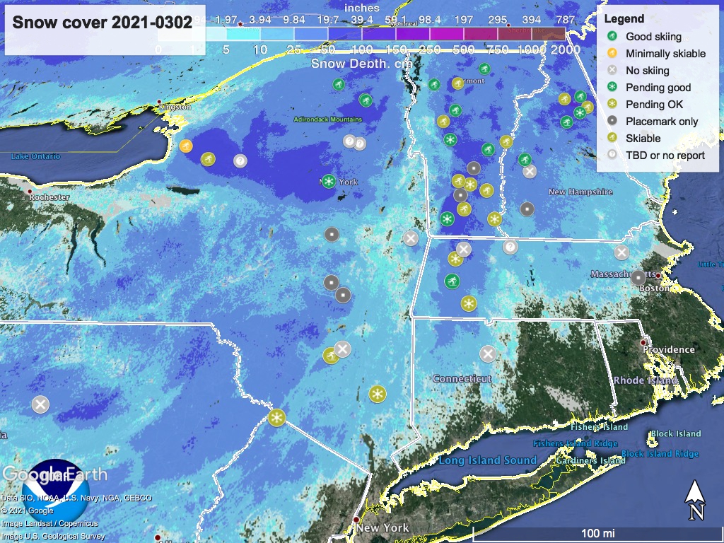
BETA report of today says several inches of new snow fell in the High Peaks, but winds have caused drifting. Breakable crust outside trails that have been skied-through. Snow depth graphic below.
Forecast
Temperatures pop up on Wednesday, then cool down for nice skiing weather in the latter part of the week and weekend. Windy today (Tuesday), but mostly mild breezes after that. Partly cloudy north of the Catskills and Massachusetts, and mostly sunny downstate and in southern New England. Possible snow showers in the far north of NY state and VT/NH late Tuesday into Wednesday, with another slight chance of snow showers on the weekend.
The weekend looks to be good weather for skiing. A warming trend looks to be coming for next week.
For Tuesday, high temps in the north country will be in the teens, with single digits in the mountains. South of Albany and across southern New England, Tuesday temps will be in the 20s to low-30s. In the NYC metro area our daytime high will be in the mid-30s. Stiff breezes generally and strong winds of 30+mph at elevation and in the mountains, generally from the WNW.
Wednesday will be significantly warmer: mid- to upper-30s in the north, with mountains in the 20s; upper-3os to upper-40s from central NY to southern New England. The NYC metro region will get to about fifty degrees.
Snow showers possible in central NY state during the latter half of the week, extending through the weekend. A cooling trend starts on Thursday, with daytime temps in the north country ranging from the teens to low-30s, while downstate NY and southern New England will be in the upper-30s to low-40s. Strong breezes from the NW.
Friday the cooling trend continues: single digits in the mountain north, teens to mid-20s in the northern lowlands, and mid-20s to mid-30s for the regions south of the Catskills and Berkshires. Breeziness continues.
Saturday and Sunday start to warm up a bit, with north country high temps going to the 20s (teens in the mountains); upper-20s to about forty degrees from central NY and southern New England down to the NYC area. Winds will be calmer compared to Thursday and Friday.
Monday of next week will continue the warming trend, with high temps in the upper-20s to upper-30s in the far north (low-20s in the mountains and up to 40 in low-lying areas). In the downstate NY area and up the Hudson valley we’ll see low-30s to low-40s. Coastal New England will get to the upper-30s and low-40s.
Thanks for reading.
