
This post contains section links to Conditions and Forecast.
Summary
Today the word from the groomed-trail touring centers up north is ‘tenderizing’, as in breaking up a frozen surface to be more accommodating for skiing. A couple of places have held off updating or have called conditions too sketchy for now. But it’s gratifying to see that Fahnestock, High Point, and Minnewaska are continuing to groom diligently.
Sad to say this weekend doesn’t look like much fun for skiing in the coastal area or downstate NY. We many not get a lot of rain on Saturday, but combined with very warm temps, we’re looking at losing a significant amount of the snowpack. If an area you like avoids getting a lot of rain, early morning will be the best time to get out on the trail.
Midweek next week looks to be better for skiing, with spring-like conditions ranging from frozen crust to loose granular. As to where, it will depend on what happens to the snowpack. Stay tuned.
A pretty good freeze looks to be coming Monday night; decent groomed trail conditions for Tuesday will require trail crews to get up really early for multiple passes with the Ginzu groomer. Ungroomed or backcountry trails are likely to get more crusty by Tuesday morning. Take care in locations that received rain with daytime temps in the 40s prior to Monday night, as it may be icy.
Conditions
Hope you got out to ski midweek, as the weather was awesome! Snow conditions were a bit wet and soft, but if you went out in the earlier part of the day things were decent.
It was definitely a week to have the Maxiglide tm or Swix F4 tm and a scraper with you. A hint about warm and wet days: try not to let your ski bases pick up any water. Skiing through a puddle, going from sunlit snow into shade, or putting warm skis onto the snow can all result in water droplets forming on the ski base (particularly in the section with the grip pattern), which then causes snow to cake up.
I should probably mention that water adheres to dirty surfaces, so it helps to keep waxless ski bases clean and prep waxed. Although there’s plenty of info on waxing performance and race skis, here’s a video solely about waxing waxless recreational skis:
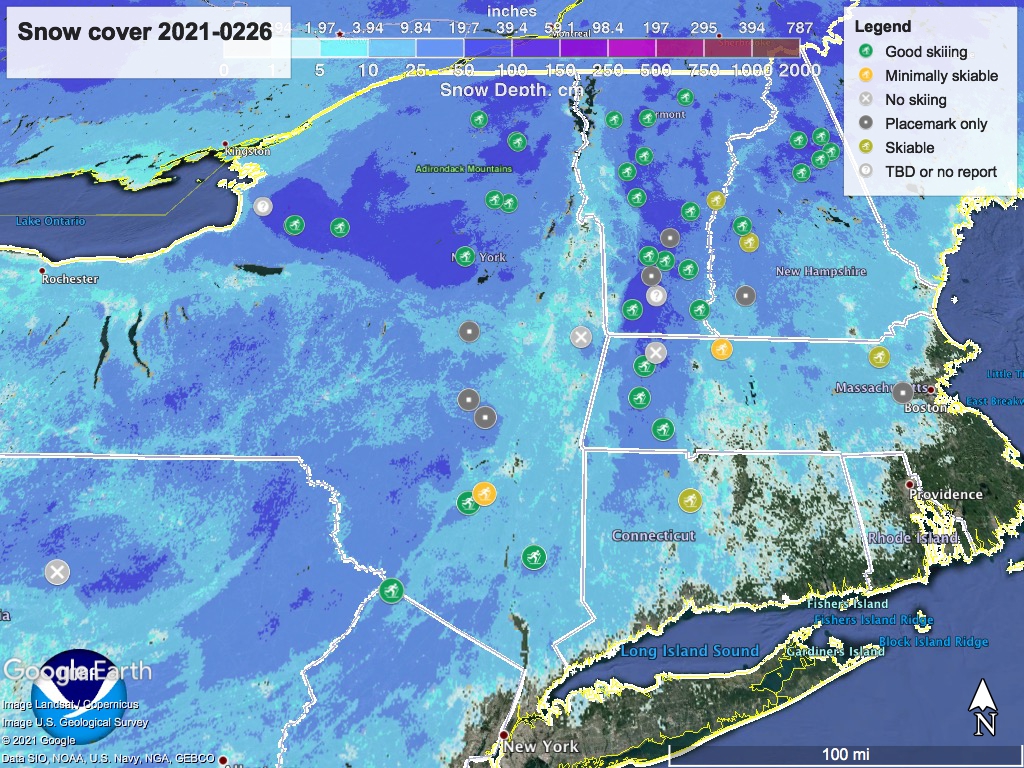
If you want to scope out where to take those freshly-waxed skis, hit ‘State of the touring centers‘ here or in the menu above for reported conditions. The visual state of our current snowpack is below:
Forecast
A long band of precipitation currently stretches across the country to our southwest. A series of fronts will form starting later today (Friday) and go on through the weekend. Most of the northeast US will see some rain on Saturday, and possible rain showers are forecast for Sunday. Coastal areas up through the mid-Hudson valley will receive the greatest amount of liquid precipitation. Low-lying areas in the far north will also get rain or wintry mix.
The Tug Hill plateau and Adirondacks have the best chance of avoiding rain/wintry mix. The higher elevations of the northern Green and White Mountains might also get lucky.
Either way, Saturday and even Sunday look to be warm and wet across the northeast. Even higher elevations of the far north will rise to the upper-30s to low-40s during the daytimes, while downstate will be in the 40s and NYC will hit fifty degrees.
Colder air moves in slowly from the north starting Monday. Increased winds can be expected across the northeast US, with strongest winds and gusts in the north country and mountain areas. Northern areas will see daytime temps drop a few degrees, but the thermometer won’t change as much south of the Albany and MA-VT/NH border. Some snow showers are possible on Monday across the northern mountain regions. Nighttime temps will be much colder, dropping to single digits in the north country and mid-20s downstate.
Tuesday will be clear and winter-like temperatures return for the day. North country will be in the 20s, downstate and coastal areas in the mid- to upper-30s. Some spots could be windy.
Wednesday and Thursday of next week look to hold a chance of rain showers, and warmer daytime temps. Downstate and NYC metro will be in the 40s, mid-Hudson valley and Catskills in the mid-30s to low-40s, and north country in the 30s except for high elevations.
