
This post contains section links to Conditions and Forecast.
Summary
The weather looks iffy and damp in the NYC metro today (Friday), but even a short ways north the precipitation today is more snow than rain. Expect the close-by areas to hold up well for the weekend. Every place I check has ‘skiable’ conditions or better- that’s really rare.
During the next 7 days, warm temps and periods of precipitation will alternate with colder, drier air.
Change to areas in conditions report: At this point I have 50+ areas in my list of touring centers, so when a new area is added for conditions check (as one reader asked for) I have to relegate one to ‘Placeholder’ status- and Mountain Trails is the one. They haven’t opened at all so far this season, despite promising to do so. The new entrant is Great Brook Ski Touring Center in Carlisle Massachusetts.
Conditions
The snow will be softer and damper the further south today (Friday), which will make trails and tracks soft and a bit heavy. Bring your scrapers and Maxiglide®. Downstate region looks to get a refresh of snow on Sunday, while up north the amount will be less. Without new snow, the existing snowpack will become firmer and faster. Grooming will take care of that and make for great tracks. Backcountry could get a bit tougher with a crust.
For groomed trails, ski at High Point, Fahnestock, Minnewaska. If you want to try ungroomed or just somplace closer by, try Rockefeller State Park, Ward Pound Ridge, maybe the Old Croton Aqueduct or even the Bronx River Park trailway.
BETA report of 2/3 is brief and blissful: “The Lake Placid area has received a foot or more of snow. It’s nice powder and will make everything reported in the earlier report fully skiable.”
For next week, the ups and downs of temperature will make for a rutty and crunchy snowpack in southern areas of the northeast. Groomers might have to use those Ginzu groomers I’d noted two years ago.
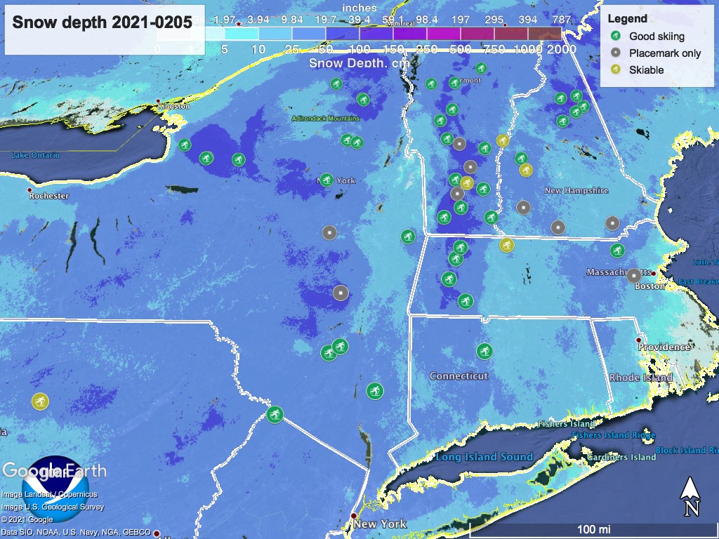
Hit up ‘State of the touring centers‘ or in the menu above for details. For an overall look at where the snow is, see the snow depth graphic below:
Forecast
Have to go day-by-day because of multiple shifts in temperature and precipitation potential through the week.
Friday 2/5: Mixed precipitation across much of the northeast due to warm and moist air coming from the south. Upper 30s to low 40s downstate and lowlands; mid-20s to mid-30s in the north country and higher elevations. Inland areas will likely see more snow than rain. Some accumulation possible in central NY and the Catskills.
Saturday: winds shift westerly and chances of precipitation decline, but significant lake effect snow is expected for the Tug Hill plateau and a dusting for the Adirondacks.
Winds over the next several days will generally be modest in southern regions, but the edge of a polar vortex may bring some strong winds to the far north country and the vicinity of Lake Ontario.
Sunday brings snow across the entire northeast as winds shift southerly again. Accumulation likeliest in the NYC metro and downstate region, and a dusting the north country. Daytime temps in the upper 30s along the coast and low- to mid-30s in lowlands and valleys. Areas further inland and at higher elevation will be in the 20s, and mountain areas in the teens.
Next week will be a ‘lake effect’ week, as prevailing winds through much of the week lay intermittent snow showers on the Tug Hill plateau and the far northern reaches of New York and Vermont.
Monday: winds shift westerly to bring colder air from the polar vortex sitting over the Midwest and central Canada. mid-20s to low 30s downstate, mid-30s along the coast. Upstate and inland areas will be in the low- to mid-20s, with higher elevations in the teens- mountain areas could be in single digits. Slight chance of snow in the downstate region.
Tuesday: moist air meets cold air, and- a moderate chance of light rain or wintry mix along the coast and southern New England, with slight chances for snow from the mid-Hudson region northward. A bump in temperature brings the downstate region back up to mid-30s to low-40s; mid-20s to low-30s in the north country, with mountains in the teens.
Wednesday: westerly winds make any lingering precipitation snow, and daytime temps fall back down to upper-20s to mid-30s downstate and in the NYC metro; low- to mid-20s upstate, with mountains in the teens.
Thursday temps will be similar to Monday’s: mid-20s to low 30s downstate. Northern areas will be in the low- to mid-20s, with higher elevations in the teens- mountain areas likely to see single digits.
If you made it all the way through that weather forecast, thanks for reading.
