
To be honest, I don’t know if I’d want to repeat the same snowstorm of Monday day after day, but having a good one where the snow will stay awhile is nice.
This post contains section links to Conditions and Forecast.
Summary

Fahnestock will be open tomorrow (Wednesday), as will High Point. Minnewaska is digging out from 18+ inches and grooming is in progress. Mohonk trails have lots of drifted snow, but if you’re up for a bit of breaking trail in soft conditions, it sounds nice.
For those in NYC, Central Park and Prospect Park should be skiable! Also see ‘Nearby parks and trails‘ or the placemap for trails and touring centers.
Best days for skiing will be Wednesday-Thursday, or next Sunday-Monday. Ski anywhere you want- it’s now as good as we can hope for.
Expect some gusty winds through the week, so dress and pack accordingly. Temps will rise gradually to the upper-40s downstate by Friday and another weather system arrives. Rain is likely on Friday across a wide swath of the region including the north country. Temps will cool somewhat for the weekend and slight to moderate chance of precipitation remain throughout Saturday and Sunday.
Conditions
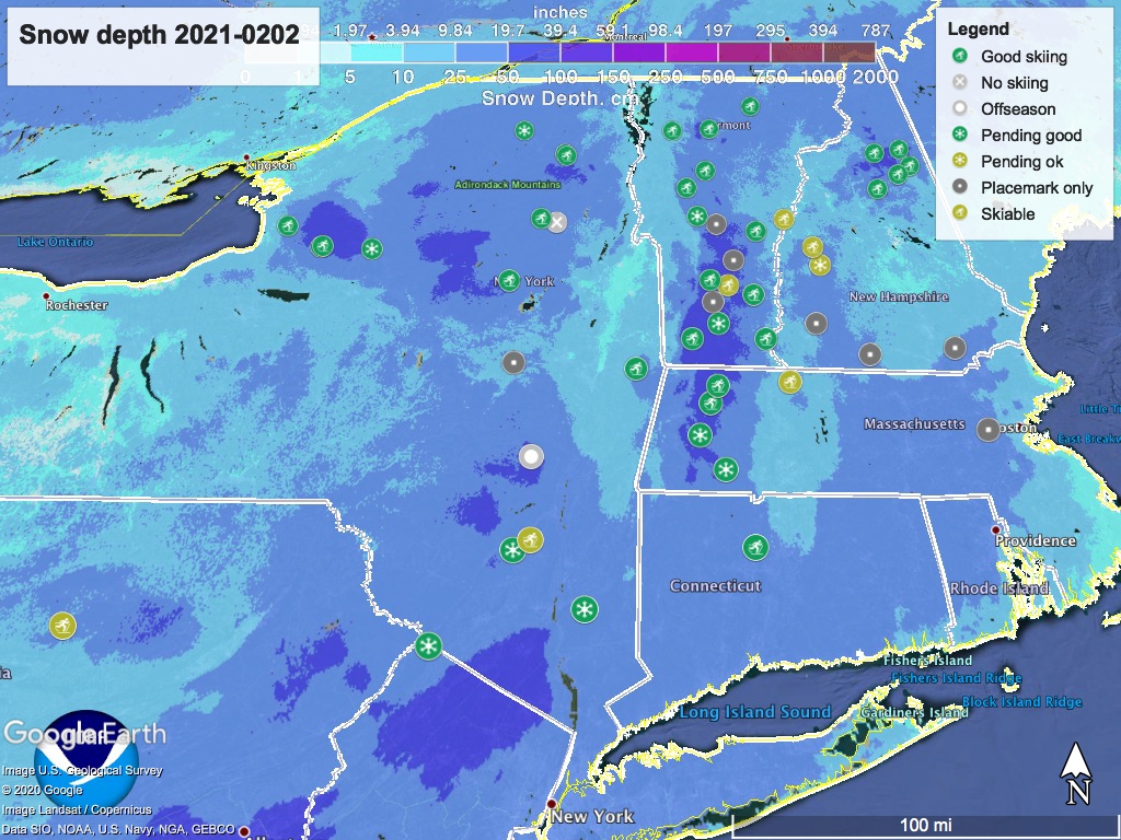
I had to create a new ‘status’ to indicate prospective conditions for areas that are clearing and grooming today and will open later in the week. The additional markers use a color corresponding to skiability status, with a snowflake icon to differentiate them from ones where skiing is currently available.
We received a heap of somewhat damp but good snowball-making snow. Excellent for soft classic-skiing conditions for a day or two while the snow settles and compacts further. BETA report from 1/31 shows very nice conditions in the Adirondacks.
Hit up ‘State of the touring centers‘ or in the menu. Snow depth graphic below:
Forecast
Wednesday daytime temps in the upper 20s to mid-30s downstate and the valleys, 20s to low 30s up north. Winds of 10-15mph, stronger at higher elevations. Expect some gusty winds for the week, and high winds in excess of 30mph are likely for the High Peaks and Green Mountains through Saturday.
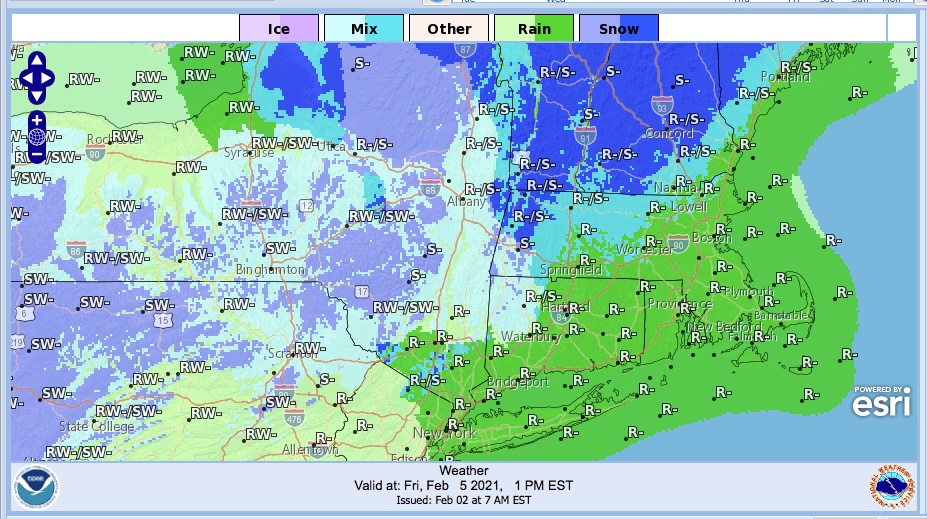
The next weather system moves into the area late Thursday. Due to a warming trend in the latter part of the week, rain and wintry mix are likely on Friday across much of the northeast. Slight to moderate chances of precipitation remain throughout the weekend. As you can see from the graphic weather forecast for Feb. 5 below, precipitation types for Friday will be decidedly mixed:
Friday marks the high temps for the week, to the low 40s along the coast, mid- to upper 30s inland in the mid-Hudson region. Farther north, mountain areas might be in the 20s but even parts of the north country will be in the upper 30s.
Saturday and Sunday temps will be mid- to upper 30s downstate and the valleys, teens to mid-20s in the mountains and higher elevations. Starting Saturday any precipitation in the north country will be mainly light snow, with a moderate likelihood of snow showers in the Adirondacks and Tug Hill plateau of New York, and the Green Mountains of Vermont.
Monday things will cool down more, to the mid-20s in the downstate region and lowlands of the north, and single-digits to teens in the mountains. A slight chance of snow throughout the northeast on Monday, with greater likelihood in the Tug Hill plateau, Green Mountains, and Berkshires. Winds will be 15-20+mph.
Thanks for reading.
