
This post contains section links to Conditions and Forecast.
[Update Sunday 1/31]: The mid-December storm fizzled for those of us hoping for a major snowfall at Fahnestock and High Point, but late Saturday NWS issued warnings for the downstate area, with snowfall totals of 20+ inches in some parts. As of today the storm looks to be severe, with snowfall rates of 2″ per hr. or more, and high winds. The projections are just a bit short of the threshold for blizzard warnings on Monday. Basic word: wait it out and stay indoors tomorrow. Shovel only to keep a clear path for opening the doors.
Original post continues below.
Summary
The coming week is the one for a downstater to get to the close-by areas and ski. The lucky ones who are retired or can set their own work days might want to take off Wednesday or Thursday to ski.
Mother Nature has a good-news/bad-news week for us. The good news: the downstate region could get several inches of snow early next week. The bad news: warm weather and possible rain are coming at the end of the week. Welcome back the typical winter nor’easter.
This photo posted by Prospect Mountain just makes me jealous:

Conditions
Minnewaska and Mohonk trails are skiable, but you may want to take an older pair of skis. High Point in New Jersey has managed to groom 2k of trail with the snow they received last week. It only stands to get better with the snow coming early in the week.
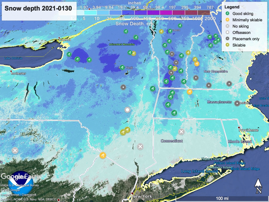
Every place that had skiing last weekend improved due to whatever snow they received during the week. The consistent temperature patterns of over the last two+ weeks seem kind of odd for the northeastern US, to be honest. BETA report is very brief, as conditions haven’t changed much, except for a light dusting of snow in the ‘dacks.
If I were a touring center operator I’d be wishing for an entire season like the last 2-3 weeks, minus the impact of Coronavirus to our lives. Despite pandemic, maybe the early-season sales of skis and the MSM stories about cross-country skiing are realizing a partial-silver-lining aspect potential as told in ‘A ski season unlike any other‘.
Hit up ‘State of the touring centers‘ or in the menu above. Snow depth graphic below:
Forecast
Temperatures start moderating Sunday. Precipitation enters New York State from Pennsylvania, hitting the western, central and southern tier portions as well as downstate, in late afternoon. Winds will be light and east-northeasterly.
Starting Sunday afternoon a nor’easter forms as existing cold air to the north meets a low of moister air south of NYC and Long Island as it moves north and east.
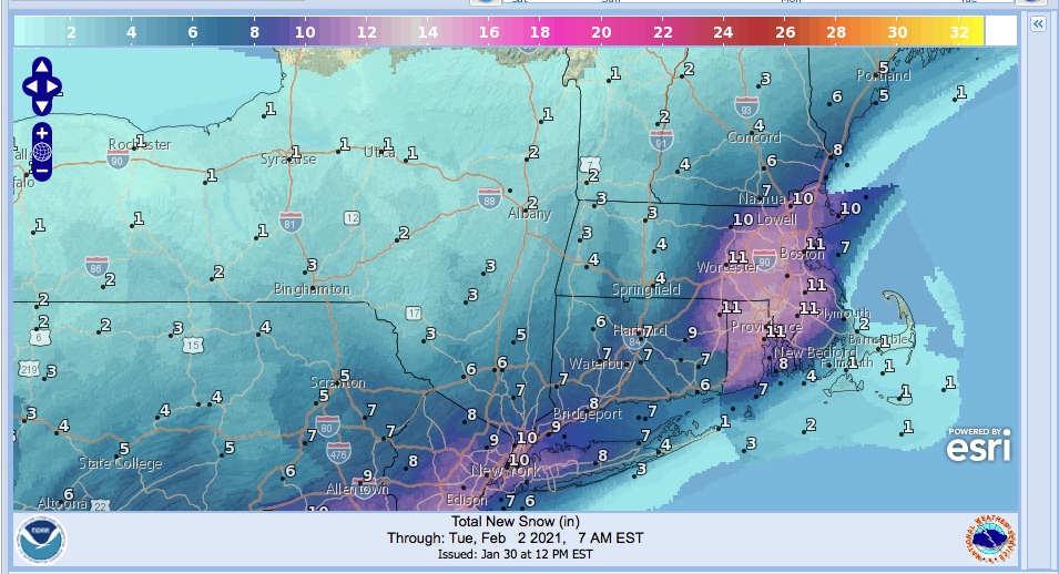
Light snowfall in the NYC metro is likely overnight into Monday, as the precipitation line starts to move across the Tristate region and southern New England. Heavier snowfall likely across southern NY and New England Monday evening and into Tuesday. Precipitation may extend up as far as the Adirondacks and Green Mountains. As is normal for this type of storm, there is considerable uncertainty in the amount and extent of snowfall, but at this point (Saturday morning) it looks like the NYC region will get 4-8″, while the Catskills might get only 2-3″.
As the front moves eastward Monday, winds in the downstate region will shift northerly, and the downstate region will experience stiff breezes in excess of 20mph. By Tuesday morning the area of precipitation will extend across the entire New England seaboard and NYC region. Light snow might continue across all of eastern NY and the New England states throughout Tuesday.
High temps in the early part of the week will be upper-20s to low 30s downstate and in the lowlands, and low- to mid- 20s in the north, teens in the mountains. Excellent news for whatever snow we do get.
Precipitation will leave the NYC metro region and most of New York and northern New England Tuesday night. By mid-day Wednesday the precipitation is all over for us, and we’ll have what we have, with light northwesterly winds. Temps however, will be on the rise going to the upper 30s downstate, mid-20s to low 30s up north.
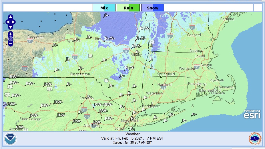
On Thursday, winds shift westerly then southerly, and precipitation approaches from the west. On Friday the warming trend will turn any precipitation in the downstate region into rain, even in the north country. Friday daytime temps downstate will get to the upper 40s, and even much of the north country will be above freezing.
There’s several days until then, and the forecast may change. Keep your fingers crossed it doesn’t go badly for us or the snowpack. Thanks for reading.
