
Prep the skis, because you may not see snow out your window but it looks like a fairytale three-day weekend is coming up.
Summary: Light to moderate snow has been and will continue to refresh a few lucky trails in the north country (see Jackson Ski Touring, Bear Notch, Waterville Valley, Craftsbury). Some areas could get several inches by the end of Thursday. Then a major snowstorm will arrive in the middle of MLK weekend and dump new and fresh powder broadly across the region. Bluebird days with clear cold weather on Friday, Monday and Tuesday bookend the weekend.
BETA reports as of yesterday that snow is gone in lower elevations of the ‘dacks, and hard and icy where it exists. However a good snowfall should make the “gentler terrain skiable again”.
‘State of the touring centers’ is updated. I won’t bother with the snow depth graphic this time around.
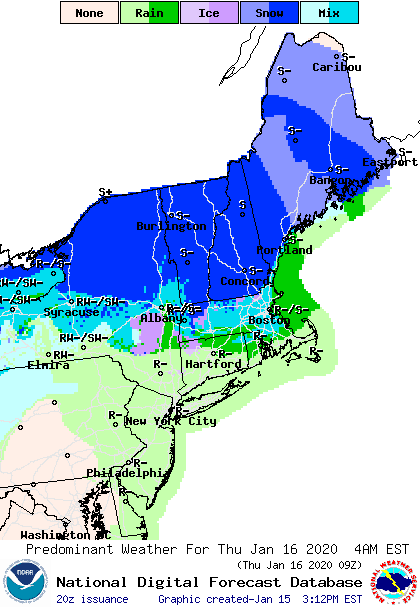
Forecast: Light to moderate snow north of Albany and the Vermont-Massachusetts border on Thursday, with several inches accumulation possible in the far northern areas by Friday morning. Daytime temperatures across the northeast will range from just below freezing to the upper 40s today (Wednesday) and Thursday. NOAA forecast graphic for Thursday early morning:
Winter temps make a brief reappearance Friday, ranging from single digits (cold finally!) in far northern New England and New York (ie, the High Peaks, Northeast Kingdom, White Mountains), and Maine, to around freezing in NYC. Some lake effect snow could give Tug Hill and central NY a bit of additional snow.
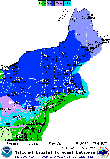
A real winter storm is due to arrive from the west Saturday afternoon and extend into Sunday. Areas across the southern Adirondacks and New England could see 8+” of snow. Osceola could get more than 12″. Dare we hope it snows enough on the mid-Hudson or downstate region to make some tracks?

Daytime temperatures for Saturday and Sunday will be in the teens and 20s in the far north and higher elevations, and upper thirties in NYC. The storm may start as snow in the downstate region on Saturday but is likely to end as rain and or ice/sleet. We’ll just have to see how the rain/snow line moves. Here’s a forecast graphic at the time snowfall is likely to be at its widest extent during Saturday evening:
Bright and cold MLK day and next Tuesday. Daytime temps will be in the single digits in the far north and higher elevations, with highs in the 20s for southern New England and the mid-Hudson valley.
Thanks for reading! Get those skis ready.
