

Summary: call in sick next week, because you should go skiing. This update includes current as well as forecast ski conditions and weather for next week.
Best days to ski: Sunday and through next Thursday(!), because a storm will arrive Saturday afternoon and temperatures favor keeping snow around through all of next week. For today the closest skiing is at Notchview, Prospect Mountain, Brattleboro Outing Club, and Lapland Lake.
Where the best skiing will be: For now, that would be the High Peaks, Craftsbury, White Mountains, and Waterville Valley. Closer by, Garnet Hill and Lapland Lake are doing well. But just wait for it…
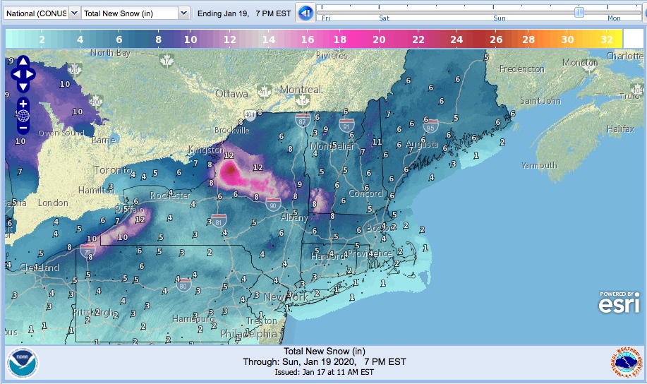
By Sunday, the greatest amount of new snow will fall on Tug Hill, which means the AMC trip this weekend is going to have some happy campers. If you’re in the mood for the drive, you’ll be skiing in falling snow at Osceola on Sunday. Prospect Mountain looks to get dumped on, so their trails should be awesome. Canterbury just needs a few more inches to reopen. The heroes at Notchview have hung tough, so their reward is coming, as is Lapland Lake’s. Garnet Hill is already grooming and tracksetting 30k of trails, so they’ll be great by Sunday. Backcountry near Garnet Hill should be OK.
Touring centers in the Green Mountains will be revived by Sunday. And don’t feel bad for the northern Adirondacks, Waterville Valley, the White Mountains, or Craftsbury. They received anywhere from 2-9″ during the week, so they’ve had good skiing since Wednesday and it’ll just get better.
As of yesterday, BETA reports 4-6″ inches of ‘dense powder snow’ fell in the ‘dacks during the week. Things are definitely looking good for backcountry skiing this weekend.
Where to stay: Didn’t plan ahead, did you? Well, Canterbury Farm has a few rooms. Lapland Lake has a couple for tonight, and lots open up starting Monday night (hint-hint). Garnet Hill has one left for Saturday-Sunday nights and lots starting Monday. Mountaintop only has cabins this weekend, but rooms available next week. Anywhere else, just Airbnb it or stay at the Super 8.
And what about Minnewaska, Mohonk, or High Point? Their fate comes with two big IFs: they need a solid 4+” of snow, and they can’t afford to get rain. We won’t know till early morning Sunday, but if both those things come through on the plus side, we could be able to ski there Sunday late or Monday. I’m not so hopeful about Fahnestock, but let’s keep a smile on.

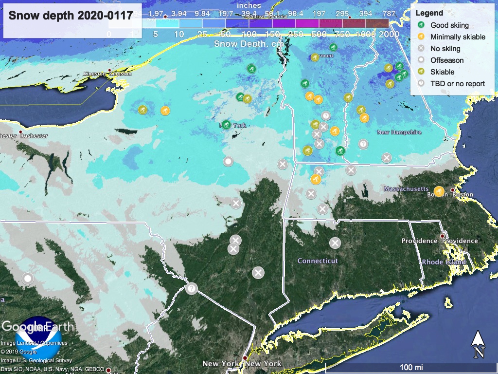
As usual, the ‘State of the touring centers’ is updated. Snow depth graphic as of today is below, and keep scrolling for the forecast.
Forecast: Snow enters the northeast region from the west, starting late morning Saturday. By evening, the rain/mix line starts moving up through the NYC metro region, but areas north the Hudson Highlands will still see mostly snow.
The storm will start to clear out Sunday morning in the southern region, but linger in the north country for the rest of the day, and in Tug Hill and central NY through Monday.
Today, highs in the single digits in the far north and higher elevations, to about freezing in the NYC area. Saturday and Sunday’s highs 20-40 across the region, Monday low teens to around freezing.
Tuesday high temps will drop back to single digits up north and about freezing in NYC, and Wednesday warms up to the teens in the north and 30s in downstate. Thursday continues the warming trend, going up to the high 20s in the far north and around 40 in the NYC metro area.
Good news is that night time temperatures will be below freezing throughout the northeast- so we’ll hang onto the snow we get.
Thanks for reading. Pack up the wax kit with blue and green classic- it’s hard to have a better opportunity than what’s coming.
