

Well, that timing worked out. Touring centers had Tuesday and Wednesday to clear debris and prep for some new snow Wednesday night, making for a huge turnaround in the skiability report. However, note that “Your Snow Quality May Vary”, depending on where you choose to go this weekend.
Hit the ‘State of the touring centers’ link above for statuses, or read on for the executive summary.
Spring skiing
In the lowlands and downstate NY/southern New England. You’ll be kicking klister (although things could get complicated with a cover of new snow this weekend), but skating should be pretty good.
Minnewaska got only about 1″ yesterday, but the trails are still skiable. Antelope4455 reports: “Upper Awosting (Green) is only groomed up to the power line. Hamilton Point (Yellow “H”) 4.7 km, Millbrook Mountain (Yellow) 4.0 km, Castle Point (Blue) 7.4 km have been groomed. The Lake Minnewaska (red) 3.2 km trail will be groomed today.” Advise caution on Library Hill (leading down from parking lot to the beach), as there could be a dusting of snow that obscures ice and gravel beneath.
Fresh powder
Just a bit further north the situation improves dramatically. Maple Corner farm, Canterbury farm, Pineridge, Notchview, and Northfield (to name a few), have all been refreshed by new snow. However, the powder might not have adhered to the icier spots underneath, so be advised that surface appearance isn’t everything.
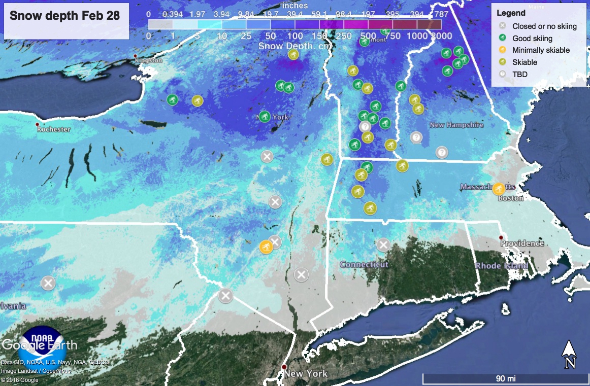
In VT and upstate NY, the snow was fluffy and the temps lower. Brand new powder and cold temps mean hard wax and slower glide, but I’ll take it! Snow depth map at the end of this section.

Regardless of where you go, caution advised for backcountry or off-piste skiers because the light snow can cover over and obscure objective hazards (eg: ice, crust, debris)
Weekend weather
The short answer is: unpredictable precipitation ahead.
Chance of light snow in metro NYC area Friday and into Saturday, which in our area will likely mix or become rain. This looks to be a mild front that will mostly affect downstate NY and the mid-atlantic.
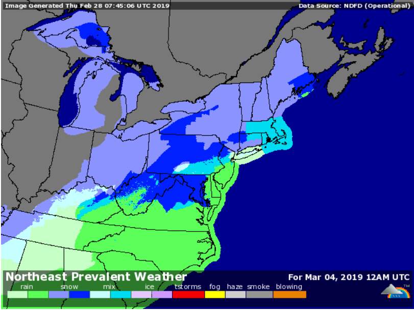
On Sunday a more significant weather event arrives from the west, lasting into Monday morning. How much precipitation and what type we’ll get is, well, up in the air. Seems like no one wants to predict amounts at this time. The image below for Sunday evening shows every possible kind of precipitation in different spots across the tristate region and southern New England:
On Monday, temps drop to a wintry level again.

Thanks for reading. Happy trails and I’m outta here-
