
It’s felt like winter again! Snowfall late last week followed by a cold Friday night set up a hard snowpack. A dusting of snow followed that and makes for some pretty good skiing, if potentially challenging in spots. The good conditions should hold up for another day or three, and then we hope for another refresh of snow for the coming weekend.
The closest places to ski for downstaters are Pine Ridge and Canterbury Farm, with Prospect Mountain or Notchview being alternative choices.
This post is about conditions for Feb. 26, 2023, and forecast for the upcoming week. See jump links to Conditions and Forecast.
Conditions
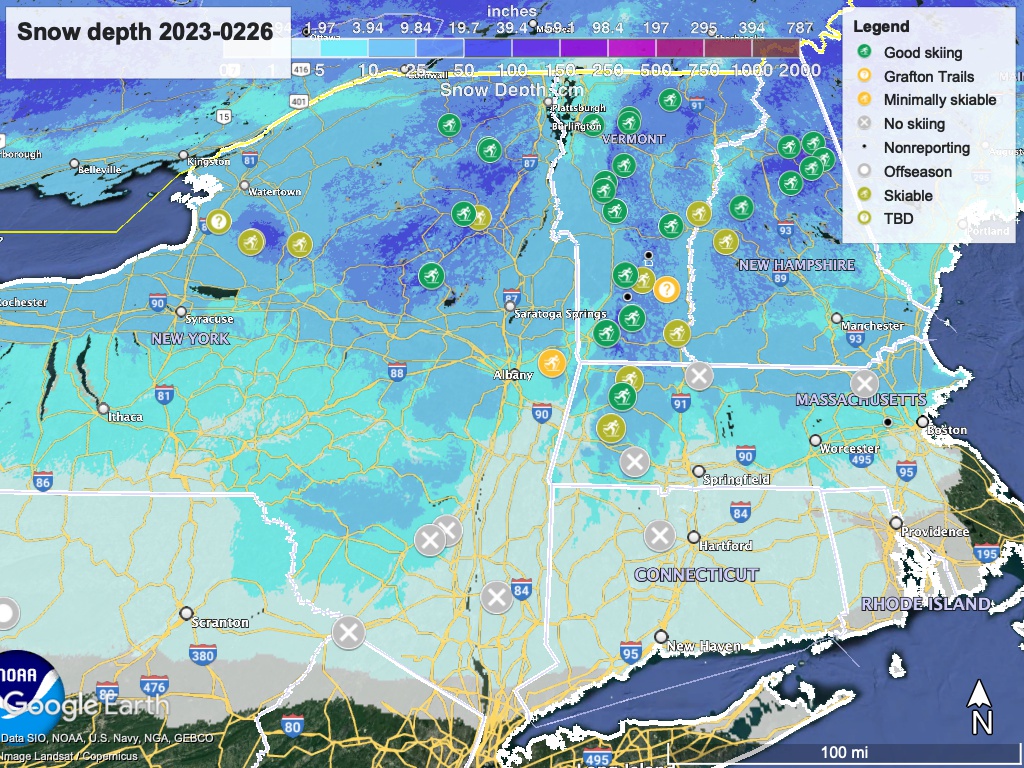
Ski trails are among the beneficiaries of our transformed winter landscape. It’s about time, even it the goods have been spread out a bit sparingly. Hit up ‘State of the touring centers‘ or in the menu above for reported conditions as of today. Snow depth graphic below:
Forecast
Precipitation will be changeable through the workweek, as three separate systems work their way through the region.. We’ll receive snow, rain, and snow/wintry mix according to the specifics of the storm, temperature, and time of day.
Snow or flurries in the far north Sunday evening. After a pause, snow and mixed precipitation spread across the region Monday evening and overnight into Tuesday morning. The precipitation will become more mixed during the day Tuesday and into the overnight period, There’s a chance upstate NY, VT, NH, and southern ME will pick up several inches of snow by Wednesday morning. The lower Hudson valley could even see a few inches by Tuesday.
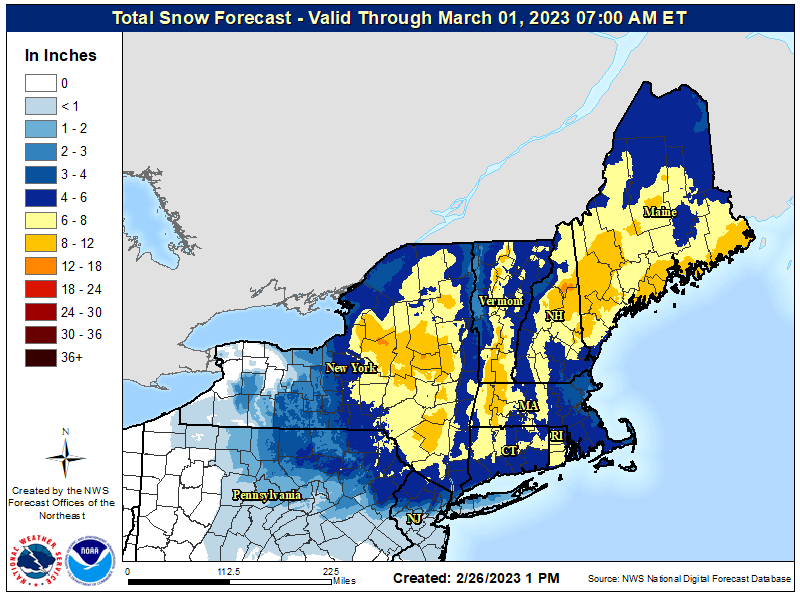
With warmer temperatures on Wednesday, precipitation will become more rain than snow. The rain/snow mix may continue until Thursday evening before converting to a wintry mix or all snow for the northern areas. Rain, snow, and wintry mix will likely go on through Thursday and Friday before clearing on Saturday.
| Daytime temps | Sunday 2/26 | Monday 2/27 | Tuesday 2/28 | Wednesday 3/1 | Thursday 3/2 | Friday 3/3 |
| Northern NY, VT, NH | 20s to low 30s | teens to 20s | 30s | 20s to low 40s | 20s to low 40s | teens to 30 |
| NYC metro and coastal New England | upper 30s to 40s | mid to upper 30s | upper 30s to mid 40s | 40s | mid 40s to upper 50s | low 40s |
What effect the midweek warmth and possible rain will have on the snowpack is anybody’s guess. Forecast for later in the week is uncertain as to amount and type of precipitation. Maybe we’ll get lucky. In the meantime, get to it if you can.

Thank you for an excellent article on history of the x-country ski binding systems !!!
LikeLike