[Update]: Wednesday Jan. 25.
NYC may break the ‘snowless days’ count of 321 by Wednesday evening. Better yet, a bounty of snow will await skiers for the weekend, possibly as far south as Minnewaska and Mohonk. Even Fahnestock might get enough snow to open a few trails.
The winter storm on Monday ended up dropping a mix of rain, ice, and snow across southern New York and as far north as southern Vermont. Heaviest snowfall was along a line running through Great Sacandaga Lake across southern Vermont toward Laconia New Hampshire. Lapland Lake and Prespect Mountain got 10″+, while Wild Wings received at least 5″, as did Notchview. Although the latter remains closed while cleaning up trails from branches and trees felled by the heavy snow and ice.
The second set of low fronts on Wednesday will bring precipitation starting in daytime and extending through the overnight.
This post contains section links to Conditions and Forecast.
Conditions
Well, what do you know? With just 4″ of wet snow, Minneaska groomed a few trails for skiing! Very thin cover and rock skis highly recommended, but kudos to the crew at Minnewaska for a job well done.
Snow, and the glint of ice decorating evergreens is beautiful to look at. But wet and heavy snow on top of ice or rain is a chore for the touring center operator. The worst effects of this were in the Berkshires, just north of the rain zone. Hit up ‘State of the touring centers‘ or in the menu above for the conditions as of Tuesday.
BETAtrails reports conditions in the backcountry are skiable but with caution. The arrival of something resembling winter is appreciated. Their conditions page also lists details for the groomed trails in the Lake Placid area.
Forecast
Through the next weekend daytime temperatures will be in the range of recent norms for winter, meaning mid 30s to high 40s in the NYC region, and low 20s to upper 30s in northern areas. While day-to-day highs will swing 10-15 degrees, nighttime lows will stay below freezing in the north and mountain areas, meaning ski areas can make snow.
There will be a big assist from Mother Nature in the form of a storm that will strike starting Wednesday. Downstaters, keep those mud boots handy; upstaters, have a shovel around. There are likely to be changes in precipitation as the temperature warms toward Thursday’s highs for the week.
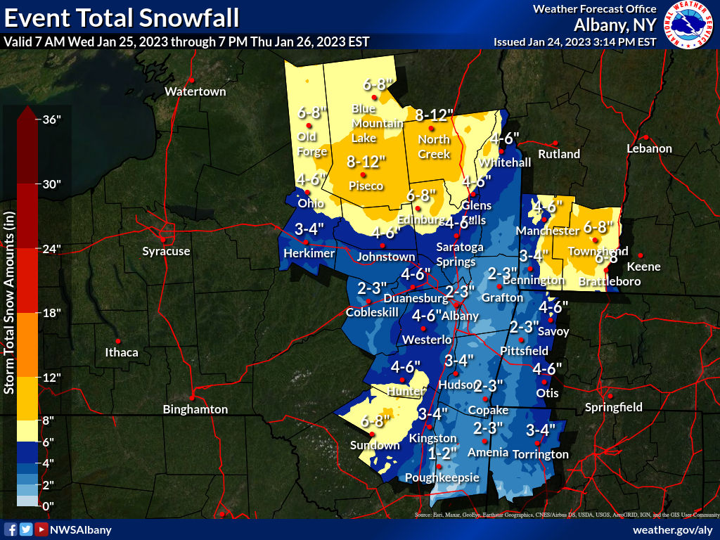
As of Wednesday morning the National Weather Service has issued advisories across the region. Brief targeted summary:
- Putnam County (Fahnestock): 2-4″ snow and ice, with gusty winds. Slippery road conditions.
- Ulster County (Minnewaska and Mohonk): 5-8″ snow, 0.1″ ice, and gusty winds. Similar forecast for Catskills and southern Adirondacks but with slightly more ice accumulation.
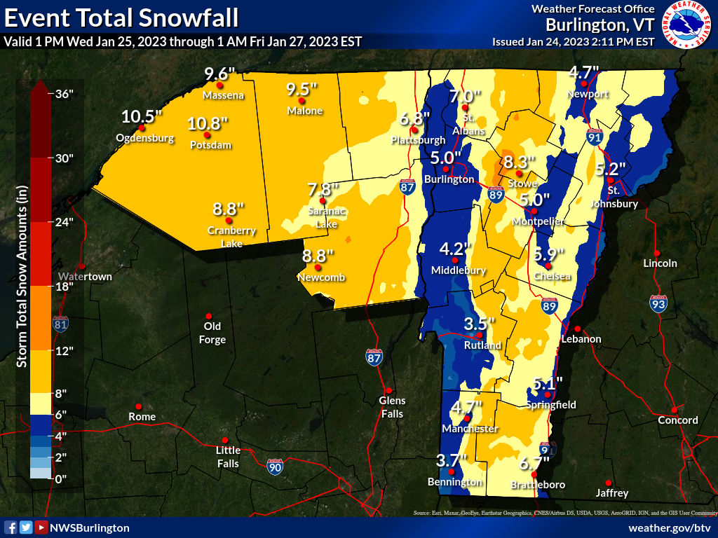
- Northern Adirondacks and central/northern Vermont: 6-12″ snow, 0.1″ ice, heavy snow possible at times.
- Western NY (Tug Hill area): 3-6″ snow and ice.
Starting during the daytime and with heaviest snow overnight, xignificant accumulation is expected in the Adirondacks and Vermont before the storm moves off into Maine on Thursday. The Catskills and White Mountains should get a reasonable dump. The Shawangunks and Berkshires? Maybe just enough snow vs. rain in parts. Magic high-ball says ‘wait and see’. We downstaters will get a few inches overall.

By Thursday New York City might actually get a small amount of snow (which might then quickly be rained or melted off), ending the snowless streak of 320+ days.
The real news for skiers is the forecast snowfall for elevated areas of Vermont and New York State, possibly including the Shawangunks.