
This post contains section links to Conditions and Forecast.
Summary
Regroup and go
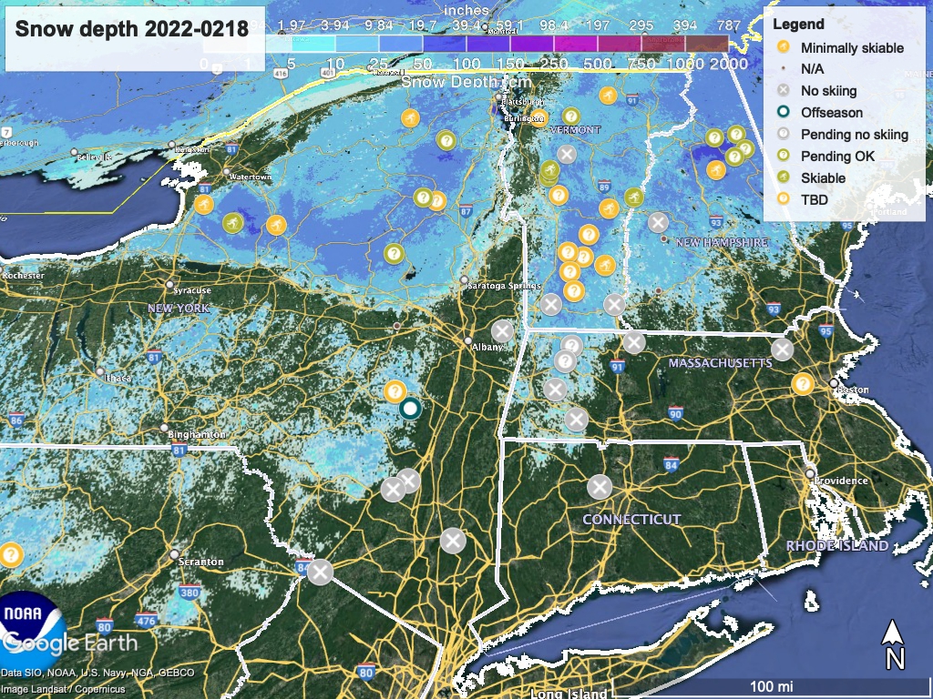
Potentially decent skiing for the long weekend, but only where two conditions are met: a) snowpack hasn’t melted away; b) someone has come through to scrape the icy mass and turn it into particulate matter. The first depends on where- see the snow depth graphic below for guidance. As for the second, that will take time and multiple passes of grooming machinery, so most likely Saturday late morning will be when touring centers are ready.
Or wait it out
Warm weather in the first part of next week, with rain or wintry mix all day Tuesday, so pack your board games. Best chance for cooler weather and some snow in the latter part of the week.
Conditions
The rain hit almost everywhere pretty hard; lots of touring centers have closed the trails to let them drain and will reassess later, grooming when possible. The cooling temps and winds will help dry out the snow, but might also create ice. The rain melted off the snow cover everywhere south of the Adirondacks and Green Mountains; we no longer have any groomed trails less than a four-hour drive from NYC.
BETA report as of 2/18 says there’s still a decent backcountry base, but it needs much more than the bit of snow they got to be skiable. They say that Mount Van Hoevenberg groomers are ‘regrouping’ to plan for grooming the non-competition trails, Cascade is grooming, and Paul Smith’s VIC says the trails are in ‘rough shape’.
Hit up ‘State of the touring centers‘ or in the menu above for reported conditions as of today. Recommend looking into details of markers with (?) because many areas are assessing today for opening on the weekend. The Snow depth graphic shows how much snow got melted off in the last 48 hours:
Forecast
Following the rain Thursday night into Friday morning, strong winds are bringing in colder air and temperatures are dropping throughout the day. Lake effect snow and snow in Upstate New York, Vermont, and New Hampshire, with some freezing rain possible in the valleys. Strong winds will continue.
Saturday temps will be cool: in the mid-30s to low-40s downstate. Northern areas at elevation will stay below freezing, ranging from the teens to mid-20s, but the lower-lying valleys will get to the low-30s. Breezy conditions will make for a significant wind chill. Much of the northeast will get snow or snow showers throughout Saturday, although the coast and NYC metro might only catch a bit of it from midday through late afternoon.
Warming will start after that as southerly winds bring warmer air. Sunday’s high temps will be still be in the mid-30s downstate, but the elevated parts of northern areas will warm up slightly, to the upper-20s. Weather for both Sunday and Monday (President’s Day) will be dry.
On President’s Day, almost all of the northeast US except at high elevation will be well above freezing- low-50s in the NYC metro, 40s across the southern tier of New York and the Berkshires in Massachusetts, and mid-30s to low-40s in the Adirondacks and Northeast Kingdom of Vermont.
Tuesday’s temperature goes up a few degrees more, as the warming trend continues. A mix of precipitation arrives across the northeast, with rain and possibly frozen-type precipitation for the north, and all rain in the south.
Wednesday is another springlike winter day when the NYC metro will see 60 degrees. From the southern tier through to the Berkshires, temps will be in the upper-40s to low-50s. Much of the far north will be in the low- to mid-40s, but valleys of Vermont and Lake District of New Hampshire will get to the low-50s. A turn in wind direction Wednesday afternoon will portend a change in weather. Moderate chance of precipitation continuing.
A bit of good news arrives Thursday with some possible snow showers as winds from the north-northwest cool our daytime temps. The chances of precipitation are not very high, but this can change. In the downstate area we’ll see temps in the upper-30s to low-40s. Inland and up the Hudson Valley to Albany temps will get to the low-30s. The north will finally drop below freezing again in the daytime, with high temps in the 20s, and single-digits to teens at higher elevation.
