
This post contains section links to Conditions and Forecast.
Summary
Recent snowfall for Hudson highlands and northwest New Jersey helped keep Minnewaska and High Point going through today. but there’s a warm spell coming up. Good week to be a freelancer or retired.
We have rain in the forecast for Thursday, and although temps will go cooler for part of the weekend, things will warm up a lot during the New York school break week.
Conditions
“Firm and fast”; “Exercise care on downhills”; “new to skiing? Good day to try snowshoeing”. These were among the comments I saw on the conditions updates from touring centers. The recent warm spell followed by a cold snap has turned trails a bit hard and icy. The groomers have ground up the surface to create ‘machine groomed loose granular’ conditions on trails. In the morning these trails will be a bit frozen and fast (which can be fun), but possibly challenging for beginners who haven’t nailed their snowplow on XC equipment.
By tomorrow, those trails will be much warmer and softer, if not wet in the sun, and skiing will be truly spring-like. But beware Thursday. BETA report with update from 2/11 basically says: ski now.
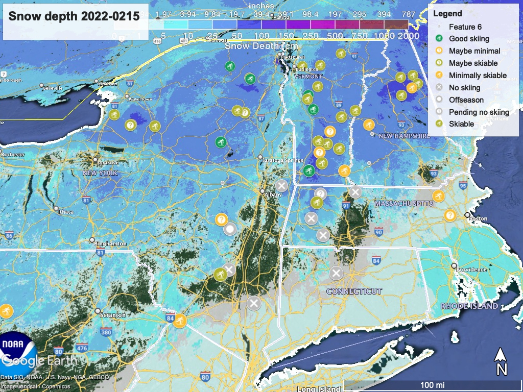
Hit up ‘State of the touring centers‘ or in the menu above for reported conditions as of today. Snow depth graphic below:
Forecast
Cool weather ends tomorrow, as Wednesday ushers in warm air from the south. Daytime temps will rise well above freezing even in the far north, possibly as high as 40 degrees, with some strong winds in the Adirondacks. In the downstate NY area, we’ll be in the mid- to upper-40s.
Thursday will be warm and wet- rain begins in the western parts starting Wednesday evening, and continues through Thursday. Daytime high temps in NYC will easily reach 60 degrees, and even the Adirondacks could see 50 degrees at the lower elevations. By Thursday night rain will have spread across the entire northeast, including the far north.
The forecast for Wednesday night/Thursday and into Friday is challenging for now, so stay tuned to your local weather. But expect heavy rain (up to 1.5″ total), and ‘strong, damaging winds’.
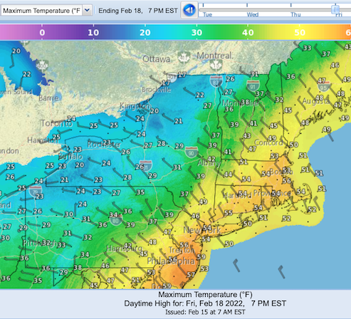
Friday, the Finger Lakes and upstate New York area may see some lake effect snow, as winds from the northwest bring daytime temperatures up north back down to the 20s and 30s. Southern New England and downstate New York will still be stuck in the warm spell, with temps in the mid-40s to mid-50s. It makes for a pretty rainbow of colored temperature bands in the forecast graphic below, but we in the downstate region don’t really want to be in the orange band indicating temps in the 50s:
By Saturday the downstate temps will be in the mid-30s to low-40s. Up north in New York it will be a bit warmer than Friday, while for much of Vermont, New Hampshire, and Maine, a bit cooler. Precipitation is forecast, and snow showers and/or wintry mix will be the result for most of upstate New York, Vermont, and New Hampshire.
Sunday looks warmer and dry. High temp for the NYC metro will be in the low 40s. Most of New York State and New England will go above freezing, except for the northern half of Vermont, New Hampshire, and Maine. Winds will be southerly.
Nature moves the thermometer up a notch on Monday, and the NYC metro will be in the low-50s. Most of the rest of the state and New England will be in the upper-40s to 50 degrees. The northernmost parts of New York, Vermont, New Hampshire, and Maine will get to the upper-30s. Monday evening we may see some rain approach the region from the south.
The icing on the cake is the NWS 6-10 day outlook anticipates the northeast is very likely to be above normal in temperature, and leaning toward above normal amounts of precipitation.
