
Latest guidance from NWS indicates low pressure area will pivot north briefly before resuming an eastward course. This gives slightly greater chances of significant snowfall in the NYC area and lower Hudson Valley. Accumulation will nonetheless drop off significantly to north and west of the city. See snowfall forecast map below:

Could be a great opportunity for those who want to get those skis out on a local park or trail on Sunday- think eastward, and near the coast. Usual caveat here: nature is unpredictable, so we could see lots more snow or significantly less.
Be careful on Saturday: Snowfall is likely to start late Friday afternoon, and the heaviest snow will begin in the wee hours of Saturday morning. There will be blustery winds to make it worthy of the term winter storm.
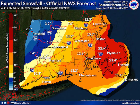
The storm will have gone off into The Atlantic by Sunday. While some groomed trails near NYC (High Point and Fahnestock) should get just enough to refresh their base, new cover will be scant west of the Hudson. On the other hand, the eastern end of Long Island could get 18″. And the further east you go, the bigger the event will be, as shown in the Boston and Cape Cod forecast map:
If even half the predicted amount hits the Boston ‘burbs, it would allow Great Brook touring and Leo J. Martin (aka Weston) golf club trails to open up.
