
This post contains section links to Conditions and Forecast.
Summary
Enjoy the snow this weekend- a February thaw coming next week for the NYC metro and low-lying areas of the northeast. Retirees and gig workers might find Wednesday a pretty nice spring-skiing day.
Best bets for a day trip: High Point and Fahnestock for this weekend. Minnewaska and Moh0nk will be great too, for a bit more driving. As the week progresses, go north.
Conditions
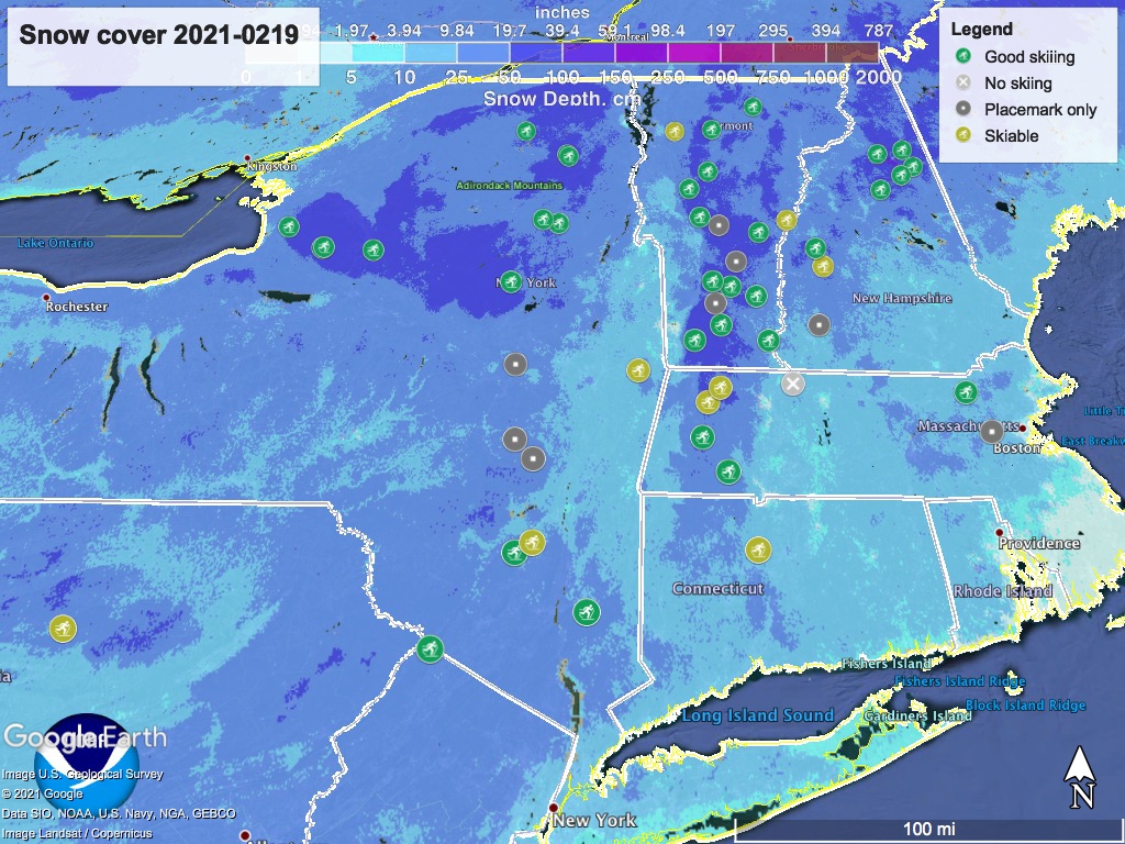
A good refresh of snow downstate and the low-lying areas of New England has helped slow down the ‘fast and firm’ tracks of a few days ago. Up to a few inches of snow as far north as the Green Mountains and southern Adirondacks has spread the love around nicely.
It all kinds of depends on grooming though. BETA report as of 2/18 advises caution in the backcountry due to breakable crust formed after the storm early this week, and crust immediately off the side of surfaces smoothed out by skiers.
Hit up ‘State of the touring centers‘ or in the menu above for reported conditions. Snow depth graphic below:
Forecast
Gradual warming trend across northeast US through the next seven days, with a low coming Monday that will likely bring rain and wintry mix to downstate NY and lowlands of the north country. Nighttime temps in the downstate region may barely reach freezing by midweek, which doesn’t portend well for any remaining snowpack in the downstate area by the end of the month.
Today (Friday): upper-20s to mid-30s downstate and in the valleys with northerly breezes, teens to mid-20s in the far north and higher elevations. Lingering snow and wintry mix precipitation through tonight.
For the weekend, Saturday temps will be similar to Friday’s, with winds out of the northwest. Some chance of snow showers from the Catskills northward. Skies will be clearing downstate and up the Hudson valley on Saturday, and by Sunday it should be nice and sunny across the entire northeast. Strong winds on the peaks in Adirondacks and White Mountains.
Sunday temps will be similar to Saturday, with wind directions westerly downstate and near the coast, southerly in the north country and western NY state.
Early next week, a front forms overnight from Sunday into Monday. Snow or snow showers possible across much of the northeast in the early morning hours before shifting to rain or wintry mix south of the Albany/MA-VT border. Most of the precipitation will be on Monday.
Daytime temps for the first part of the week will be upper-30s to low-40s for downstate NY and across southern New England. Valley areas of the far north will be in the mid-30s, while higher elevations will see temps in the teens to upper-20s. Winds will shift westerly across the northeast, and some very strong gusts could be experienced in the High Peaks, Greens, and Whites.
By the middle part of next week downstate daytime temps will be in the 40s; the NYC metro will be in the upper-40s. Low-lying areas of the north country will be in the upper-30s, and higher elevations may reach the upper-20s. Periodic light snow possible in the Tug Hill and Adirondack region, and northern VT and NH.
For Thursday some spotty fronts could bring snow the to the far north and a slight possibility of rain to downstate NY.
Long-range forecast indicates the northeast will trend higher than ‘normal’ in temperature and precipitation. Let’s hope it’s not too warm. Thanks for reading.
