
This post contains section links to Conditions and Forecast.
Summary
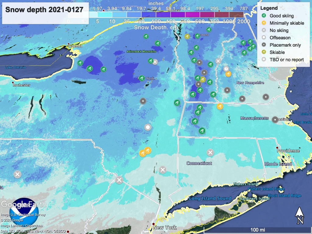
Most places in the snowbelt got at least a dusting of snow, which refreshes the base nicely for the weekend. Minnewaska and Mohonk are ‘minimally skiable’, but you should expect to hit gravel in spots so rock skis are recommended.
Things are looking good for the weekend, but temps will get truly cold on Friday and Saturday, with stiff winds Saturday. A warming trend brings precipitation on Sunday, but it’s hard to tell whether that will bring much snow for us in the downstate and Hudson valley areas.
Conditions
About 4″ of snow fell in the Gunks, compacting to about 2-1/2″. With a thin and icy base at Minnewaska, this should make the conditions somewhat OK, considering. Mohonk trails have more exposed gravel.
No report that High Point got enough snow to open for skiing, but the hopeful should keep watching their site.
The usual areas in New York are good bets for now and the weekend: Lapland Lake picked up 7″ of snow and the Tug Hill got 8″. BETA report hasn’t been updated since last weekend, but it looks like the High Peaks got at least a dusting of snow.
Over in Massachusetts, Notchview got 6″ of new snow. In Vermont, Wild Wings got 5″. Prospect Mountain got only about 3″, but it just added to an already-healthy base.
Be prepared to use your car as your lodge/basecamp. Check policies and capacity limits before travel, and buy passes in advance if necessary. Bring your masks and practice safe distancing at all times.
Hit up ‘State of the touring centers‘ here or in the menu above. Snow depth map below:
Forecast
Chance of light snow across the northeast region today and tonight. Light snow probable in the Finger Lakes region and likely in mountain areas of NY and VT through the remainder of the week. Some accumulation possible from Finger Lakes through the Adirondacks to the northern Green Mountains.
Daytime temperatures will trend downward starting tomorrow (Thursday), when it will be single digits to low 20s in the north country, and upper-20s to low 30s in the downstate and Hudson valley region. Friday and Saturday daytime temps in the north country will be downright freezing, ranging in the single digits to low teens even in flatlands north of Albany and the Massachusetts border, and could be below zero at elevation. In the NYC metro region it will be teens to mid-20s. Overnight Friday and Saturday, you’ll be feeling the winter.
As might be expected with a cold front, winds will be out of the northwest and will pick up to 10-20mph Thursday. Along with the cold, expect winds on Friday of 20-25mph in elevated areas. Winds will moderate somewhat for Saturday.
Starting Sunday temperatures start trending up: teens to low 20s in the north country, and mid-20s to mid-30s downstate and the Hudson valley. Winds will shift northeasterly.
Precipitation comes with the warming trend, and it’s probable that the downstate and mid-Hudson regions will see some precipitation starting Sunday and through Tuesday. Due to warming temps the NYC and mid-Hudson region is likely to see a mix, but areas at higher elevation could see snow.
Monday and Tuesday start the month of February with temps in the north country ranging from the 20s to low-30s, while the NYC metro area will be in the mid- to upper 30s. Winds pick up a bit on Tuesday, but remain relatively mild nonetheless.
Thanks for reading; get out skiing!
