
Conditions for 1/21/21 and forecast. This post contains section links to Conditions and Forecast.
Summary
Snowfall on MLK weekend refreshed and restored the base on trails and at touring centers across the region. Snowfall today and tomorrow is making conditions the best they’ve been at some areas.
Pineridge is the closest touring center to us in NY state, and has excellent conditions. If you were in Massachusetts, Notchview likewise has great conditions. Regrettably and in a recall of last season, everywhere downstate or the mid-Hudson is bare and brown.
Cold weather and wind coming in for the weekend. Best day of the weekend for skiing will be Sunday.
Ah, to be vaccinated and have the week off.
Conditions
Today (Thursday) the Tug Hill plateau is under a Lake Effect Snow warning, lasting through Friday. The Adirondacks, and northern Vermont may also be in for a nice refresh of snow. Lesser refreshes possible in the lower Adirondacks and southern Green Mountains. Windy conditions possible on Saturday, particularly in the mountain regions.
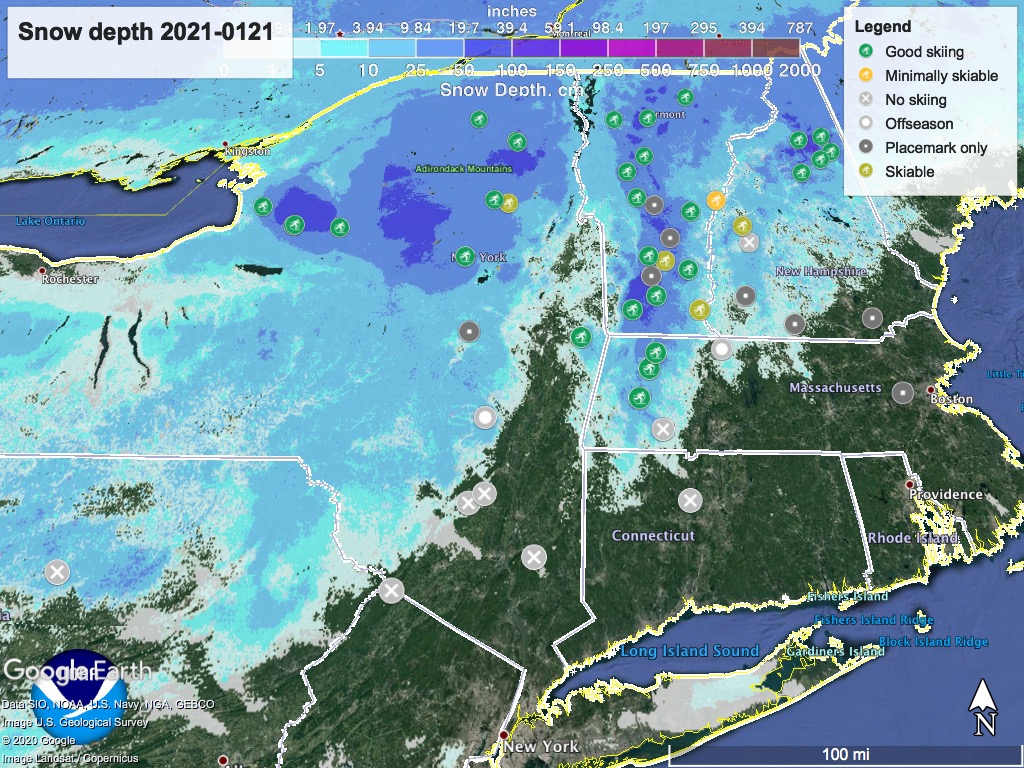
Hit up ‘State of the touring centers‘ or in the menu above. Snow depth graphic below:
Forecast
Snow in the northern parts of NY and NH, and all of VT today (Thursday). Snow will continue through Friday, ending Saturday. Overall, several inches accumulation expected in the Tug Hill plateau. Significant accumulation also possible in the High Peaks area of the Adirondacks and northern Green Mountains.
Temperatures in the northern areas will be in the 20s to lower 30s through Friday, winds light and south or southwesterly. On Saturday winds shift to come from the northwest, chasing out the last of the precipitation and bringing colder weather.
Daytime temperatures take a dip on the weekend, heading down to freezing in the NYC metro area, mid- to upper-20s in the Hudson valley, and single digits to teens in the north and mountain areas.
Saturday will be authentically chilly with winds of 10-20mph, highest in elevated and exposed areas of the north country. Winds will moderate on Sunday. Overnight temps from Saturday-Sunday will drop below zero Fahrenheit, so that might be a night to go for koselig instead of camping. Skies will clear somewhat for the weekend.
The early part of next week will bring temps back up to the low- to mid-30s in the downstate region, and low teens to mid-20s in northern areas. Clouds will increase during this part of the week as well. A slight chance of snow showers across the region Monday-Tuesday.
