Snowstorm watch for Dec. 16-17
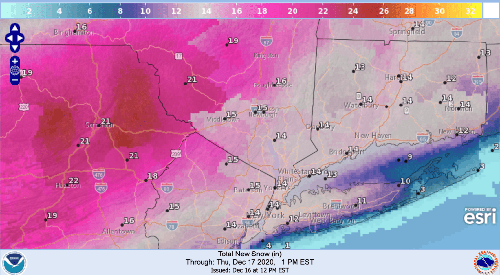
[update Wednesday 12/16]: The snow-generating band is now expected to be a bit north of predictions earlier in the week. The Catskills should now get significant snowfall, while New York City has only about a 50% likelihood of getting more than 8″ of snow from now through Thursday afternoon.
I would expect Minnewaska State Park and Mohonk resort to have ample amounts of snow, High Point should get a very large dump, and Fahnestock should get sufficient snow to groom. High winds tonight could make things a bit tricky unless they can move some of the drifted snow onto the trails.

[original post follows]
Get your shovels and gravel, and go find those windshield brushes and scrapers. After being snubbed all last season by storm tracks that laid snow down a hundred miles north of us, the first real winter storm of this season is due to hit downstate NY and especially eastern PA right in the kisser.

As is typical for winter weather in the northeast US, a cold front from the north will meet warmer wetter air from the south moving up along the coast. There can be a lot of uncertainty in the horizontal and vertical movement of air and moisture, and exactly when and where the two fronts meet, but in this case the National Weather Service has begun to make snowfall predictions days in advance- and that means they’re pretty sure.
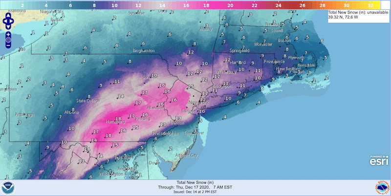
The track of greatest intensity in our area will be on a northeast heading running across northern New Jersey and the lower Hudson valley. Accumulations could be 18 inches in southeast Pennsylvania, over a foot in northern New Jersey, and about a foot just north of NYC. Depending on exactly where the warm front moves, the city could get anywhere from a few inches to nearly a foot of snow.
What’s this mean for skiing?
The good news is the snowfall will come at a perfect time with respect to the weekend: just far enough ahead that roads can be cleared and grooming can take place. Even better, the weather is going to be cooler than last week, with night time temps in the low- to mid- twenties. That will help keep the snow from melting.
Unfortunately the snow will fall on bare ground without a preexisting base. If you went skiing on the new fallen snow, your skis could sink down and scrape the ground. Gravel or pavement needs a snowfall of 6-8″ to keep skis from hitting bottom. On grass however, a cover of 4-6″ will suffice. And once compacted over several hours (or by someone else’s skis) it will be fine. Check out my nearby parks and trails and maybe use your ‘rock’ skis.
Groomed trails will always be easier to ski on. And in conditions where the snow is already compacted, you can think about breaking out those brand new skin skis or skate skis.
Wonder of wonders, the track of greatest intensity will go right over High Point in northwestern New Jersey and Fahnestock near Cold Spring. They should get enough to groom, and given that the snow will stop Thursday morning, they could have some nice trails ready for the weekend. The further north, the lesser the accumulation however. Minnewaska State Park and Mohonk resort near New Paltz are likely to get a decent amount of snow, but will it be enough to ski on or groom? Stay tuned.
If you haven’t already gotten your wax kit out and prepped your skis, there’s no time to lose.