
It’s a Leap Year so we get an extra day to enjoy February and winter conditions, at least where the snow’s at! This post contains section links to More info and Forecast. Stay tuned for updates periodically through the day with updates from ski centers.
Summary
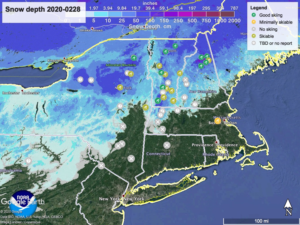
[Friday 1:30pm] ‘State of the touring centers‘ is now updated. Areas toward the southern extent of the snowline and at lower elevation went through rain and then a hard freeze overnight. Expect a lot of grooming work to be done today, but a bluebird day tomorrow. Several areas are listed as ‘no report’, which may simply indicate the groomers are too busy to call in an update. (Note: The Trustees of Reservations websites, hosting Notchview, Canterbury and other Massachusetts areas has been loading slowly or not at all today.)

[Friday 9am] The early word: Pineridge got 2″ of snow and is open. Prospect Mountain received 1-3″ of new snow and says snow surface is packed powder. Lapland Lake is grooming and clearing debris, and expects 24k to be open today. Wild Wings is open and grooming, expecting a high of 25˚F today. Mt. vanH received 4″ of new snow, with some additional expected today as they pack and track. Craftsbury got 10″ and is continuing to get snowfall this morning.
A warming trend will bring spring-like temperatures throughout the northeast by Wednesday, so get some mid-winter ski days this weekend, and spring skiing Monday or Tuesday.
More info
Four inches new snow, ranging from heavy wet snow yesterday morning to dry blowing powder overnight. We are clearing debris from the combination of wind and heavy snow so do not expect to have all trails open today. We estimate we will have approximately 24K snowcat groomed and tracked by mid-day today
Lapland Lake conditions report, Feb. 28
As has been typical for this season, snow is a few hours away from the NYC area, but once across the geographic snowline, there’s ample snow. The issue today is some areas got quite a bit, and with the wind they have to do a lot of clearing as well as grooming. Trail conditions will be soft and a bit tricky today, but should be great tomorrow.
From Osceola Tug Hill XC: “8-12 additional inches of snow today. It is hard to know the amount of snow in the last 24 hours as it was pretty windy yesterday. With measurements and liquid recorded at the weather station, best guess is 13 inches of snow so far. West wind today – some of the forecast has the snow heaviest just to our north… wait till tomorrow for snow totals.”
Rain Thursday has impacted touring centers and snowpack south of Albany and the mountain areas of VT and NH. Anywhere from 1″ to 8″ of snow, ranging from wet snow to powder could accumulate in northern NY and New England, with up to 32″ on the Tug Hill plateau, by midnight Friday. Breezy winds Friday may make for difficult grooming or skiing. Winds will die down Saturday, making both weekend days or Monday morning potentially good to great days for skiing.
BETA report of 2/27 was just updated today (Friday), indicating more snow than expected, but high winds will have caused drifting, so some areas will have bare crust and others deep drifts of snow.
Hit up the link or nav menu item ‘State of the touring centers‘ for reported conditions. Snow depth as of 12am Feb. 28 correlates to terrain elevation or being in the lake effect zone.
Forecast
Friday: teens to upper-20s in the north country, freezing to low 40s in southern New England and the Hudson valley to NYC metro. Intense snow expected in Tug Hill plateau and parts of central NY. Breezy with very strong winds (30-50mph) on mountain peaks.
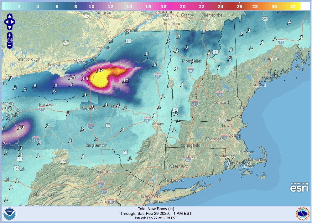
Saturday: the snow in most spots will taper off in the early morning hours, leaving up to 32″ in the Tug Hill area, and several inches on the higher elevations of the Adirondack high peaks, Mt Mansfield area, and Mt Washington, but not as much anywhere else. Saturday and Sunday daytime temperatures will be similar to Friday’s but a bit warmer. Breeziness will begin to die down Saturday.
Monday through Wednesday, temperatures will keep going up. Monday’s high temps will be freezing to mid-40s in the north, low 40s to 50 in the south and NYC metro. Tuesday notches that up a few degrees, and on Wednesday the high at the Canadian border will be about 40 while NYC will get to about 60.
Another wave of precipitation will arrive in the early morning hours of Monday, bringing rain and some frozen mix to the far north through Wednesday.
