
This post has section links for: The Black Forest; Road trip; Cross-country ski paradise; Hemmersuppenalm; Winklmoosalm; and Real Bavaria
Plan A: The Black Forest
It was a great idea: fly to Frankfurt, take the train to Freiburg and stay at an Airbnb. Then use mass transit to take daytrips from Freiburg to ski trails in the Schwartzwald (Black Forest)- places like Hinterzarten, Todtnauberg, or Feldberg, the tallest mountain in the region. No car necessary, nice university town to stay in, and cross-country skiing ready at hand.
Unfortunately, winter isn’t cooperating in Europe any more than it is in the lower Hudson valley. European weather sites showed rain and warm weather rather than snow, and Bergfex reported ski conditions showed XC trails at ‘Liftverbund Feldberg’ were almost entirely closed. The top of Feldberg, at about 5000′, had barely any snow.
On the other hand, the Bavarian Alps looked promising, and the number of trails showing open in the Reit im Winkl area was promising.
Plan B: Road trip

The German Autobahn is lovely, but there are speed limits as well as traffic jams whenever the highway is in the vicinity of a city, which is often. It’s about a five-hour drive from Frankfurt to Reit im Winkl, also known as ‘langlauf paradies’.
Geography of Upper Bavaria
In the Chiemgau region the Bavarian Alps rise abruptly from the plains. Just north of the mountains is the Chiemsee, a sizable lake. The town of Prien am Chiemsee has a beautiful view of the Alps across the lake. Most of the Chiemgau seems devoted to tourism, outdoor recreation, and agriculture/animal pastures. The mountains here are not as steep and rugged as the famed mountains of Switzerland or France, but this is better for the cross-country skier anyway.
Similarly to the Appalachians, the Alps in Bavaria are composed of sedimentary and metamorphosed rock layers formed into mountains by collision of oceanic as well as continental crust. The more jagged appearance of the Alps is because they’re hundreds of millions of years younger than the Appalachians, and have undergone much less weathering and erosion.
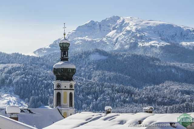
Reit im Winkl is situated in one of the lower valleys of the Bavarian Alps at 700m (2300′). The village has about the same population as North Conway New Hampshire. Like North Conway, Reit im Winkl is set in a wide valley with low mountains on one side and higher mountains on the other, but this being the Alps the valley is narrower and the mountains more rugged.
Cross-country ski paradise- sort of
If you were to imagine that the Jackson Ski Touring Foundation had taken over North Conway and turned it into a tourist destination for cross-country skiing, with a trailhead at the old railroad station and trails crisscrossing the flatlands around the Saco river, you’d have an image of what it’s like to drive into Reit im Winkl. Sounds great!
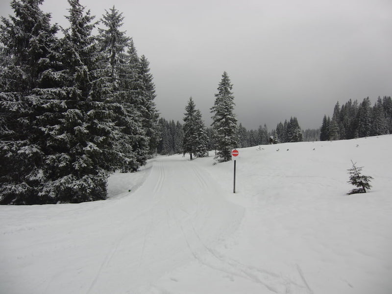
Except that this is shaping up to be the warmest winter on record in Europe, so even at 700m in altitude, the valley was green and brown, and it looked like the village has been storing or making snow and trucking it onto the fields and stadium area to maintain minimal skiing on a loop or two. The trails in the woods and just outside the village hadn’t been groomed due to thin cover. With daytime temperatures up around 50˚F, some tracks ran through puddles of water, and exposed knobs showed bare spots.
The Dream… 
…vs. the Reality
While the Reit im Winkl website listed most village trails as closed, some were actually skiable if your standards have been set by skiing in the lower Hudson valley. In the woods, the trails were frozen granular, and without any recent fresh snow or grooming, a fair amount of debris had built up. Trails in the open were very wet, to the point where you’d ski through water at times. Conventional waxless skis actually worked very well for these conditions and the flat terrain. Due to the wet corn snow in the sun and the hard, almost icy surface with debris coverage in the woods, skating in the valley looked doable but not likely to be fun.
The trails in Reit im Winkl are mostly marked as easy, and they really are. Even the ones marked moderate tend not to have grades as hard as ones in New England. In the village and on the high meadows, there are really no steep climbs, but some are long. (Note: this doesn’t necessarily apply to trails connecting the valley and higher meadows. See quote from Ken Roberts’ 2009 trip below)
Signage is good, and the greatest source of confusion is the plethora of colors: orange-red for XC skiing (with a skate or classic skier icon to denote what’s allowed); blue for winter walking, green for snowshoeing; yellow for summer walking/hiking. Trails are mixed-use in some parts, meaning classic and skate skiing, winter walking, and maybe snowshoeing all use the same path. Most classic-ski trails are double-tracked, and some trails are classic-only while others are skate-only. At Winklmoosalm the trails tend to be mixed-use, with the skate/walker lane in between single-tracks or to one side of double-tracks. Stay in line and to the right except to pass. Bring a map of course, especially because they don’t post maps of the trail system. Mind the color and trail number at intersections and you’ll be fine.
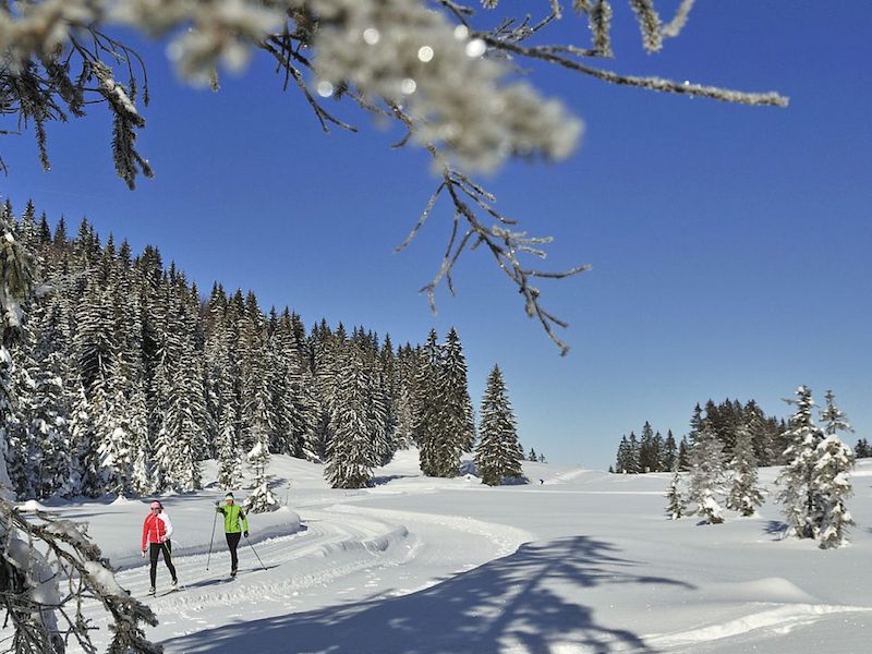
There are two higher meadows with cross-country ski trails near Reit im Winkl: Hemmersuppenalm and Winklmoosalm. The cross-country ski trails (‘langlauf loipen’) on these Alpine meadows are doable by novices with reasonable ski control and athletic ability. The terrain is no harder than that of the Castle Point trail at Minnewaska between the lake and the power line.
Even at 1200m, daytime temps on these higher meadows were around freezing, and the trail surface hardpack powder. In fact, they were so well-packed that walkers (of which there were many) could walk the skate lanes without their boots leaving any divots.
It’s not cheap to take the van up to Hemmersuppenalm or the gondola to Winklmoosalm- this year about €16/pp round trip. But the view and other aspects are so nice it’s worth it.
The total size of the trail system in the area can be a bit misleading, as some trails overlap, resulting in some double-counting in total distance. It’s a tendency in some European and even American ski centers, particularly if terrain or boundaries require skiers to be funneled on feeder trails to reach branching trails a few kilometers from the ski center. For skiers who don’t want to use the same trail segments repeatedly, the Reit im Winkl area is probably good for four to six days of unique routes, or maybe 70k total, assuming all trails are open.
Seeking the snow line
The answer to finding better conditions is: go higher. Not only because air temperature drops about 3.5˚F per 1000 ft, but also because mountains cause clouds to loft high and drop moisture as snow. Within about 45 minutes a skier can be at either of the two Alpine meadows above Reit im Winkl. Both are at about 1200m (about 1600′ higher than the valley), about the same altitude as the base of Silver Star ski resort in British Columbia. Each of these areas were reporting over 18″ snow depth.
Hemmersuppenalm
This is an Alpine meadow a bit over a square mile in area, and it feels isolated because it is. Vehicular access is limited to vans carrying people to/from the tourist information center in Reit im Winkl or a parking lot at Blindau on the way up/down. Winter walkers can take a route that ascends starting several kilometers away at Seegatterl (skiers can take this route only if there’s enough snow, which hasn’t been the case this season).
The van lets people off at a small restaurant called Hindenburghütte, maybe 70-100′ below the meadow itself. Most people walk up the steep couple of switchbacks to get to the actual trailhead. Some visitors rent wooden sleds to take a ride down the hill from the trailhead to Hindenburghütte.
There are only a couple of trails at Hemmersuppenalm, the longest being about 10k. It circumnavigates the meadows and loops back and forth on itself, around and over small rises and depressions. A notable feature is a small chapel at an intersection where skiers can choose to head back to the Hindenburghutte or continue down a fast and fun descent to do the longer route. That which goes down must then come up as the skier winds around back to the trail head.
The trails are almost entirely in the open, meaning skiers get lots of sun, but it could become challenging in windy conditions or blowing snow.
For a more in-depth description of the longer trail and the trail down to Seegatterl, I’ll leave it to this blog post by a German (in English).
Winklmoosalm
This starts off with a gondola ride from Seegatterl (where you park your car and purchase lift tickets) to a wide-open area of meadows and saddles, leading in one direction to the XC trailhead, and in another to an Alpine ski area. Cross-country skiers pay only for a round-trip gondola ride to Winklmoosalm, while Alpine skiers will get tickets to use the many lifts surrounding Steinplatte, the peak to the south of Winklmoosalm.
Winklmoosalm is busy with people but has enough space not to feel overcrowded, although that could change on weekends and school holidays. There’s a restaurant with communal tables set between the gondola and the XC trailhead, a good place for lunch or coffee after a ski, or just to bask in the sun on the patio. You can even stay up there, at one of the small hotels and inns dotting this broad shoulder off the Steinplatte.

From Winklmoosalm, the trails are mostly gentle and very wide, following summer roads and trails through the forest. Most skiers will take trail #14 or #7, and almost immediately on setting out will technically cross into Austria- but there’s no marker so it’s totally invisible where that happens. These trails get more cover from wind by being in the woods.
Trail #7 is a loop of about 5k with some ups and downs where intermediate skills would be handy. #14 goes out about 5.5k to a now-closed restaurant called Moarlack. Because it’s an out-and-back, the total distance is 11k. The way out has a couple of nice long downhills that are easy and safe due to the width and grooming of the trail. Those downhills become long (but gentle) uphill grades on the way back.
And guess what? In doing some Internet trail recon, I found the late Ken Roberts went to Reit im Winkl and skate-skied up from Seegatterl in 2009. Funny coincidence. Sadly, the snow conditions this year are too poor to ski on the trails linking the Alpine meadows and the valley.
The climb from Seegatterl up to Winklmoos was pretty tough: pretty unremitting moderate-steep or steeper
Ken Roberts, 2009
“unremitting moderate-steep or steeper”? Maybe I’m not so sad those trails aren’t skiable after all.
It would be kitschy except that it actually is Bavaria
I can’t end without making a note on the architecture and appearance of buildings and people in the Bavarian Alps.
Tourists in the area are like most in an outdoors recreation town, except in this case mainly Germans or from central Europe. The tourist and local population includes lots of cross-country skiers, enough that when taking the gondola up to Winklmoosalm with the downhillers, you don’t feel out of place. Also lots of people are around and about carrying adjustable poles for Nordic walking. The vibe is healthy, simple, and robust, and doesn’t have the brassy volume of an American downhill ski resort. I give that a thumb’s up.
The people working (or living) in the area are dressed in normal civvies- it’s not like being in movie-set Bavaria. And while some people serving in restaurants are in old-timey-looking overalls or gingham checked shirts, at least nobody’s dressed in lederhosen. As has become the custom in any location frequented by people from many places, English is the lingua franca and most of the people involved in the service industries speak it well enough.
Bavarians have a regional pride, so even newer houses tend to bear traditional architectural cues and decorative touches. On the other hand, as an American I have the feeling I’m so conditioned to faux Bavarian cues in US ski tourist towns (dark wood, fake timber construction, badly-executed decorative carving and detailing), that seeing the real thing provokes a kind of reflexive skepticism.
After a few days the wariness starts to wear off because the decorative aspects are pervasive and display a similar esthetic throughout the area, so it feels authentic and not like a crass and superficial appropriation of tradition. And what the heck- it’s their tradition so they can make it as crass as they want and it will still be authentic.
It was a bit challenging to get to skiable terrain, but well worth the trouble to get across the snowline to super-groomed trails and beautiful scenery. It definitely adds new dimensions to what a cross-country ski center can be like.
Thanks for reading.
