
A double-barrel weekend in store, with light snow Friday and then temps drop on Saturday. Ski now and then prep for much colder conditions. All the maintained trails near NYC are definitely still skiable.
This post is about conditions for Feb. 5 2026, and forecast for the next few days. See jump links to Conditions and Forecast.

What will the skiing be like?
Not to sound like a broken record but the skiing is fantastic
Marlboro Nordic Ski Club trail report Feb. 5 2026
Given the new snow and continued cold weather, there is almost no need for this report. everything is skiable and will remain so through the weekend and into next week
BETA report of Feb. 3 2026
This looks like a dog happy to run (and a skier happy to be skijoring): https://www.facebook.com/reel/917426787487419. Recommended audio track: Opening title theme to ‘The Big Country’.
A few hours north of the NYC metro, some areas in Vermont have gotten light dustings of snow over the last couple of days Same for the Adirondacks. Get some skiing done Friday, because Saturday looks to be a pretty unpleasant day to be outside. Maybe rewax the skis for next week, which looks to start out with nicer weather.
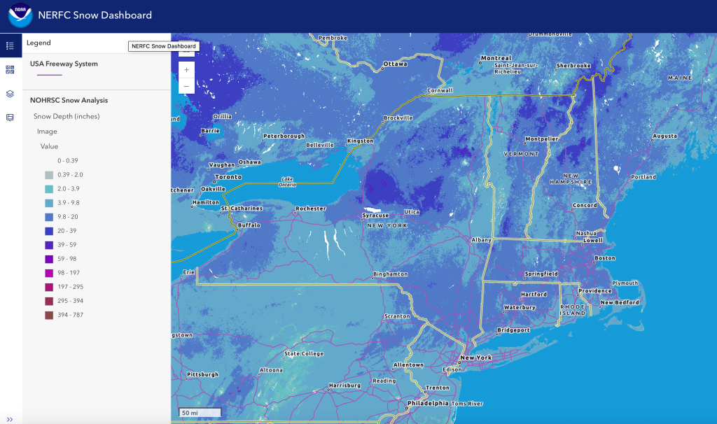
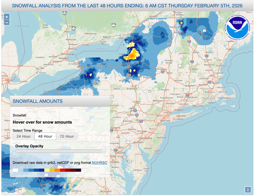
Hit up ‘State of the touring centers‘ or in the menu above for reported conditions as of today. Graphics showing now depth and snowfall of last 48 hours below:
Upcoming weather
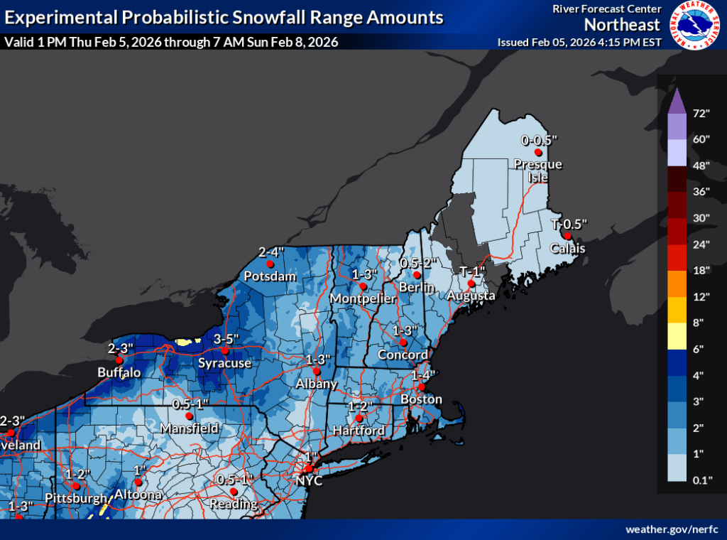
Light snow overspreading the northeast starting Friday afternoon, from west to east. Heaviest accumulations during the overnight period into Saturday. Good chances of 2″ or more in the Adirondacks and Green Mountains of Vermont, and less in other areas including the NYC metro. This will be light and fluffy snow so it won’t add much of anything to the base, but it will be nice to ski on. Winds will be calm.
The weekend:
- Saturday will turn dangerously cold, with maximum daytime temp in the morning and rapidly dropping through the day. This will be accompanied by strong winds, and gusts of 20-30+mph in the north, 35-40 in the southern regions, and possibly 50+mph along the coast and Long Island, as well as northern New Jersey and eastern Pennsylvania. Expect mostly cloudy skies.
- Sunday will be very cold as well, but winds will abate slightly. Gusts up north will still go up to 20mph, and 35 in the sourth and along the coast. Skies will be gradually clearing.
Preview of next week:
- First half of next week will see a warming trend. Wind gusts will continue to abate in the southern region for Monday, with gusts of 20mph. Winds continue to gradually get milder through Wednesday. Skies generally partly cloudy,
- Possible precipitation on Wednesday or Thursday, with snow primarily for regions north of Albany and the NH/VT southern borders. South of that line, areas from the mid-Hudson and Connecticut and below are likely to get a mix of snow, wintry mix, and rain. Wind gusts will again pick up a bit and could gust to 20mph.
Too far in advance to know what the system late next week holds in terms of the President’s Day weekend, so stay tuned.
Daytime temperatures:
| Date | Mountains in northern NY VT, NH | Northern lowlands | Hudson Highlands to NYC metro |
| Fr 2/6 | Single digits to teens | 20s | Upper 20s to low 30s |
| Sa 2/7 (highs in the morning) | Single digits | Teens to low 20s | Upper teens to mid 20s |
| Su 2/8 | Below zero | Single digits to low teens | Teens |
| Mo 2/9 | Below zero to single digits | Single digits to teens | Mid 20s |
| Tu 2/10 | Low teens | Upper teens to upper 20s | Upper 20s to low 30s |
| We 2/11 | Teens to low 20s | Upper 20s to low 30s | Mid 30s |
| Th 2/12 | Teens to low 20s | Upper 20s to low 30s | Mid 30s |
