Does it seem like the last week has been a repetition of sameness? As of today any groundhog in the northeast that came out today would have seen its shadow.
You can still ski pretty much anywhere, but footprints are probably making the surface of paths in urban or suburban parks and trails a bit dicey. Try a golf course or head to High Point, Fahnestock, Minnewaska, or Mohonk!
This post is about conditions for Feb. 2, 2026, and forecast for the next few days. See jump links to Conditions and Forecast.
What will the skiing be like?
With a week of sunny days, transformation of the snow has started to have an effect on classic skiing and kick wax. The snow is losing structure and the surface and tracks are getting a bit glazed – fast conditions but the kick wax moves toward a warmer range than the temperature alone suggests. Skate skiing remains a good option so long as the surface isn’t too smooth or isn’t covered by sugary wind blown drifts.
“Surprisingly tricky conditions for such stable snow, mainly as a result of the tracks being left over the course of a few days. But if you get the wax right this can be the best classic skiing of the year, firm and greasy tracks. As the little strip of snow at the bottom of the track gets skied more and more it transforms faster than the other snow, and the humidity pops quicker. This is also affected by the big air temperature swings, with a low of -8F overnight warming to +22F by this afternoon.”
From snow report, Great Glen Trails, NH
Conditions now are best further north and higher where the snow has stayed colder. Still, anywhere there’s snow right now is good skiing. Mother Nature has given us a gift. Get some skiing in during the week, because we go back to the freezer for the weekend.
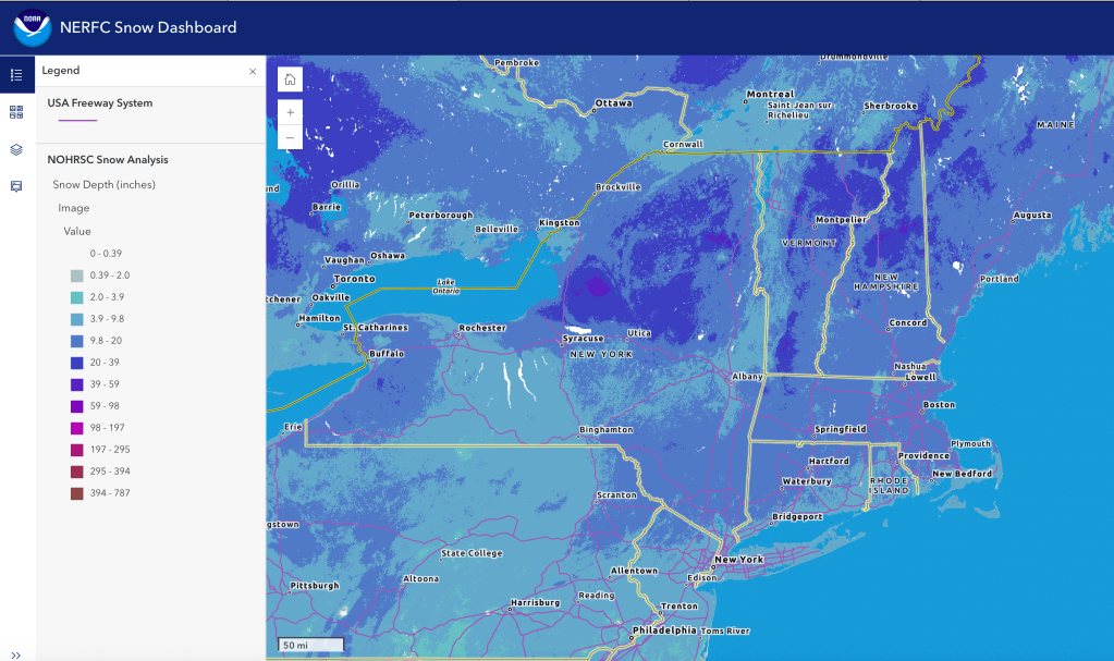
Hit up ‘State of the touring centers‘ or in the menu above for reported conditions as of today. Snow depth graphic below:
Upcoming weather
No major snowstorm in sight for the next week, just a minor snow shower late in the week. Watch for severe cold and wind chill on the weekend. By the bullets:
- Light snow for NYC metro and far north on Tuesday.
- Calmer winds Tuesday and Wednesday.
- Lake effect snow in central and northern New York Thursday. Wind gusts could be 20mph.
- Light snow spreads across the northeast Friday into early Saturday. Possible snow showers in parts of the northeast continue through the weekend.
- Much breezier on the weekend, with gusts of 30mph in the north, 35+mph in the south with even stronger gusts along the coast. Dangerously cold temperatures up north, and very strong wind gusts along the coast and interior.
- Winds abate slightly on Monday, but still very cold with harsh wind chills.
Daytime temperatures:
| Date | Northern NY VT NH mtns | Northern lowlands | Hudson Highlands to NYC metro |
| Mo 2/2 | Low teens | Upper teens to 20s | Low 30s |
| Tu 3/3 | Teens | Mid 20s to low 30s | 30s |
| We 3/4 | Single digits to teens | Upper teens to upper 20s | Upper 20s to mid 30s |
| Th 3/5 | Single digits | Teens to low 20s | Upper 20s |
| Fr 3/6 | Single digits to teens | 20s | Upper 20s to low 30s |
| Sa 3/7 | Below -10 to below zero | Below zero to single digits | Teens |
| Su 3/8 | Below zero | Single digits to teens | Teens to low 20s |
| Mo 3/9 | Below zero | Single digits to upper teens | Low 20s |