
What can I say when conditions are this great? Save hassle and spew less carbon – ski close to where you are because it’s all good! It’s so good that people from the north might go south just for the warmer temps.
For the record, conditions at the touring centers close to NYC:
- Fahnestock: great
- High Point: great
- Minnewaska: great
- Mohonk Mountain House and Preserve: great
- River to Ridge trail: groomed out.

This post is about conditions for Jan. 29, 2026, and forecast for the next few days. See jump links to Conditions and Forecast.
What will the skiing be like?
There’s so much nice, soft snow even now that it might still be better skiing classic rather than skate at the touring centers. But it also means you can ‘pick your own adventure’ from golf course to rail trail, forest and backcountry, or any old touring center. Not much snow in sight, but the snow should stay really nice if chilly through the weekend. Bring extra clothing, wear a wind shell, carry a buff or balaclava, lobster mitts and glove/boot warmers if you need.
Some thawing under the sun in warmer temps early next week, but skiing should sill be just fine.
Hit up ‘State of the touring centers‘ or in the menu above for reported conditions as of today. Need some hints or recommendations Check out these:
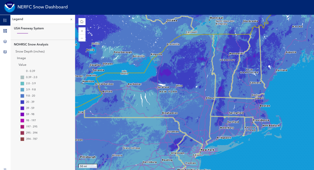
Snow depth graphic below shows lots of nice, deep coverage:
Upcoming weather
[Update Friday Jan. 30, 2026] Less chance of significant precipitation from storm on Sunday, but winds will still be higher and gusts could be 30-40mph.
Slight chance of snow showers in far north today. Lake effect snow continues for Tug Hill for the next couple of days.
Overall the weather through the Saturday will be cold, and wind will be the chief risk to being outdoors. Breeziness Thursday and Friday, with gusts of 25+mph along the coasts and elevated areas. Winds will abate somewhat for Saturday.
[As of morning of Thursday Jan. 29] A coastal storm will develop and pass by the Mid-Atlantic and New England coast thestarting late Saturday. Possibly an inch or few of snow for Hudson Highlands, Berkshires, and southern Vermont. NYC metro may get some accumulating snow, but this prospect will be very sensitive to even minor changes of the storm track. Greatest impact if any will be in southeastern New England and Cape Cod area, with a moderate chance of several inches of snow in the Boston area.
The weekend storm will also bring high winds to the Mid-Atlantic coast and southern New England. Heaviest impact will be Rhode Island-Cape Cod and southeastern Massachusetts. 35-45mph gusts can be expected in the interior, and i50mph along the coast and eastern LI. Gusts of 30+mph will be felt up through the Catskills and southern Vermont and New Hampshire through Sunday and Monday
Next week looks to start out a bit warmer than current. Winds will be much lighter than the weekend. Snow showers may occur next Wednesday, going west to east.
The image below shows snowfall area bounded to a regionfrom Central NY to VT and northern NH, following a remarkably well-defined northeasterly line.
| Daytime temps by date | Northern NY VT NH mtns | Northern lowlands | Hudson Highlands to NYC metro |
| Th 1/29 | Below zero to single digits | Teens | Teens to low 20s |
| Fr 1/30 | Below zero | Single digits to teens | Teens |
| Sa 1/31 | Single digits | Single digits to upper teens | Teens to low 20s |
| Su 2/1 | Single digits to teens | Teens to low 20s | Teens to mid 20s |
| Mo 2/2 | Teens | 20s | Mid 20s to low 30s |
| Tu 2/3 | Teens | 20s to low 30s | Mid 20s to mid 30s |
| We 2/4 | Single digits to teens | 20s | Mid 20s to low 30s |
