
Hope you enjoyed the weekend skiing, because we’re getting the ski tracks yanked out from beneath us…

… by Mom Nature, not the Grinch. I’m just visualizing it that way.
Northernmost and highest elevations continued to see some snow today. For downstaters of the NYC metro, the fun is over for now.
This post is about conditions for Dec. 9 2024, and forecast for the next few days. See jump links to Conditions and Forecast.
Conditions
Trails were great over the weekend – plenty of snow in lots of places, and cold temperatures to keep them that way. Slightly breezy but definitely tolerable on Saturday and Sunday. The snow began to melt on Sunday and refroze somewhat overnight.
Monday was an iffy day- some toruing centers said ‘come and get it’, while others were wary of the softening snowpack. Many area held off grooming and are scheduling closures for midweek, possibly from Tuesday thrrough Friday.
BETA report of 12/7 – 12/8 takes an optimistic view for the north country:
We can hope that the warmer temperatures help to firm up the base and with a bit more new snow even more terrain should be open by next weekend.
In sum, snow on trails in the south will be unskiably wet and possibly back to bare ground by end of day Tuesday, but for those that hold up (especially in the north), Thursday and Friday will be time for some aggressive grooming in order to make something skiable for the weekend.
Hit up ‘State of the touring centers‘ or in the menu above for reported conditions as of today. Snow depth graphic below:
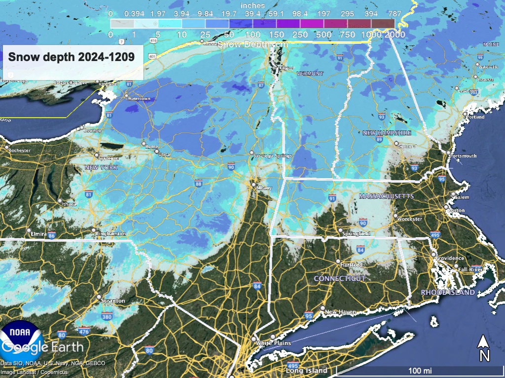
The coverage is excellent for this early in the season, and certain areas have a lot of snow with which to ‘weather’ the next few days.
Forecast
Temperatures warm to above normal on Wednesday, and significant precipitation is expected on Tuesday and Wednesday. 1-2″ of rain in the southern and coastal areas, 1-1-1/2″ of rain and mixed precipitation from the Catskills to the southern Adirondacks and lower Green Mountains, and up to 1″ of mixed precipitation further north. Rain will taper off Thursday.
A freeze returns quickly overnight Wednesday night into Thursday. By Thursday early morning temperatures will be 5 to 15 degrees colder than the previous day. Departing rain may leave some snow in the Tug Hill and High Peaks of the Adirondacks. Groooming and snow guns across the northern areas will be back to work before the weekend.
Slight chance of showers by next Sunday, as temperatures rise once again. The 6-10 day outlook is calling for both temperature and precipitation to be above normal for this time.
| Daytime temps | Tuesday 12/10 | Wednesday 12/11 | Thursday 12/12 | Friday 12/13 | Saturday 12/14 | Sunday 12/15 | Monday 12/16 |
| Northern NY, VT, NH | Mid 30s to mid 40s | Low 40s to mid 50s | 30s | Mid 20s to low 30s | 30s | High 30s to low 40s | High 30s to low 40s |
| NYC metro and coastal New England | Mid 40s to low 50s | High 50s to low 60s | Mid 30s to low 40s | 30s | Mid 30s to low 40s | 40s | Mid 40s to low 50s |
Thanks for reading. Hope for snow and colder weather soon.
