
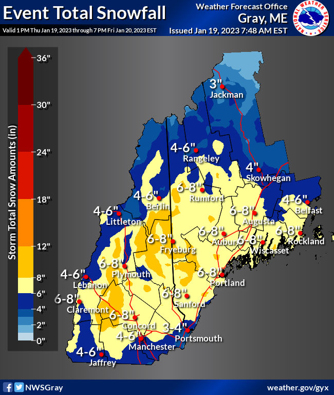
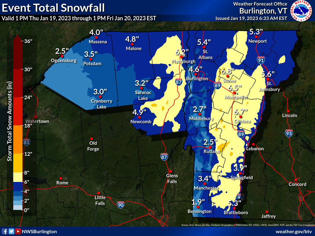
[Update]: Northern New Hampshire and Maine are going to get a major snow event. That’s the place to go. Next best will be in the Green Mountains or possibly Adirondacks.
The lower Hudson Valley and southern New England are due for some rain and mixed precipitation, with a bit of snow. There will be some slight accumulations but not enough to help if it gets rained on, and without a base it will be for naught in terms of sociability. Driving at night could be hazardous with some slippery conditions.
Further north, the Green Mountains of Vermont are looking to get 4-8″ of snow, but with some mixing. It’s the White Mountains that will hit the.jackpot with 8″+ in the higher elevations.
URGENT – WINTER WEATHER MESSAGE
National Weather Service Gray ME
315 AM EST Thu Jan 19 2023…SNOW IMPACTS THE AREA LATE TODAY THROUGH FRIDAY…
.After about a month with little snow to speak of, a significant
snowfall is expected for much of the forecast area. Some mixing may
occur at onset and across southern New Hampshire, but overall a
mostly snow event is anticipated. The bulk of the moderate to heavy
snow will fall Thursday night and early Friday. Some of the southern
portions of the snowfall may be wet and sticky, leading to an
elevated risk of power outages as snowfall approaches 4 inches.
Additional light and fluffy accumulations are likely Friday during
the day.…WINTER STORM WARNING IN EFFECT FROM 7 PM THIS EVENING TO 7 PM EST
FRIDAY…
- WHAT…Moderate to heavy snow expected. Some freezing rain may mix
in at times. Total snow accumulations between 5 and 8 inches and
ice accumulations around a light glaze.- WHERE…Portions of southwest Maine. Portions of central and
northern New Hampshire.- WHEN…From 7 PM this evening to 7 PM EST Friday.
- IMPACTS…Periods of moderate and heavy snow will combine with low
visibility to create dangerous driving conditions. The hazardous
Original post follows;
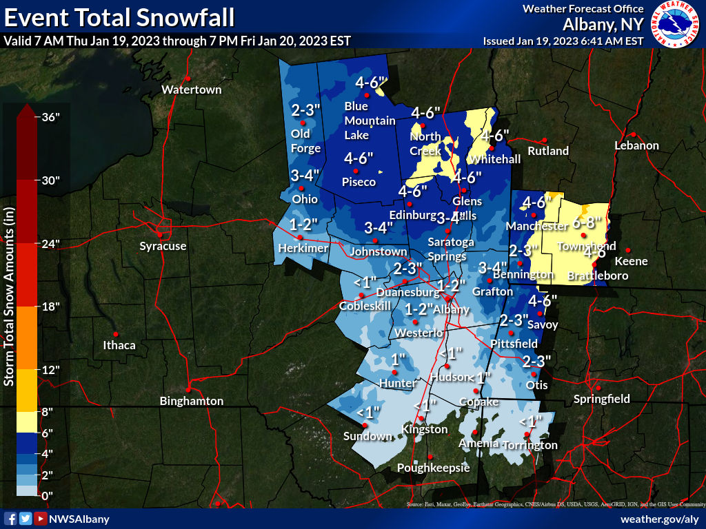
For Thursday evening and Friday, NWS includes this possibility in the forecast for the Hudson Valley and Capital region, including Minnewaska State Park:
… confidence is increasing that the eastern Adirondacks, upper Hudson Valley, and southern Vermont will see advisory-level snowfalls.
National Weather Service Albany NY, 702 AM EST Wed Jan 18 2023
While the chances for skiable accumulation south of the Catskills is poor, there are greater likelihoods in the area north of Albany and the Massachusetts border. As is so often the case, moist air moving from southwest to northeast will intercept cold air coming down from the north, so where the front happens will determine the snowfall vs rainfall line.
For the Lake Placid area, and the surrounding Adirondacks and Vermont region, things look very optimistic for skiing this weekend:
.SHORT TERM /THURSDAY NIGHT THROUGH FRIDAY NIGHT/…
As of 344 AM EST Wednesday…National Weather Service Burlington VT, 649 AM EST Wed Jan 18 2023
- Winter storm will bring 4 to 7 inches of snow to much of the
region from Thursday night into Friday night, except up to 10
inches for the higher elevations of the Adirondacks and Green
Mountains.- A period of 1 to 2 inches per hour snowfall rates looks
likely overnight Thursday.- There might a brief period of wintry mix especially for our
southern zones during precipitation onset.- Light to at times moderate snow continues for much of Friday
before tapering off Friday night.
The forecast for the White Mountains in New Hampshire is less committed to an actual measurement, but that suggests wide variability in the amout of snow vs. rain/mix,
Stay tuned.
