
Reposting to keep advice current with forecasted weather. This post contains section links to Conditions and Forecast.
Summary
With a dusting of snow across the north country, and way more than that downstate and in the Tug Hill region, conditions are nicely set up for the week to come. Thank the wandering Polar Vortex for putting an arctic stream of colder a bit southward and giving us snow instead of rain.
[Update 2/9]: Temperatures will trend colder through the rest of the week. If you’re heading north for the weekend, pack the buff and cold wax kit because that arctic stream will be making itself felt.
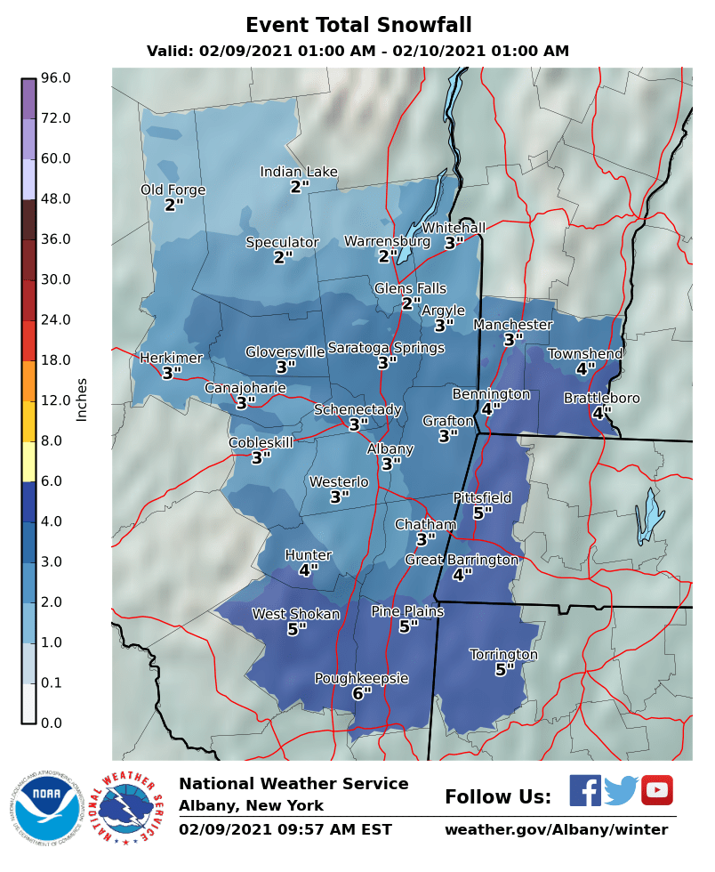
[Update 2/9]: Catskills is getting snow today (see graphic below for predicted amounts) but the Mid-Hudson area including Fahnestock, Minnewaska and Mohonk are too. However, the weekend’s precipitation forecast by NWS has considerable uncertainty. Advise regular check on weather for the place of your interest. The good news so far is that the downstate region and the closest ski centers and parks seem less likely to get rained on.
Conditions
Conditions this past week brought out the best in conditions and some pretty old skis! More good skiing to come, and a possible refresh of snow on Thursday-Friday.
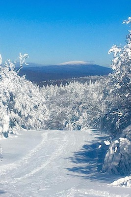
View from Prospect Mountain Feb. 8 
Wood skis at Viking Nordic, Feb. 7
BETA report as of 2/5 was good only for the weekend. Stay tuned, as it will get cold up there.
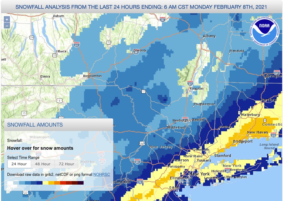
Snowfall from Sunday’s storm was concentrated in the NYC metro, but this just whets the appetite to get out. High Point in New Jersey and the Mid-Hudson region areas of Minnewaska and Mohonk got 1-3″.
Snowfall analysis graphic below. The darker yellow indicates snowfall of 8-12″, light yellow 6-8″. Shades of blue get lighter from 4-6″ down to 1-2″.
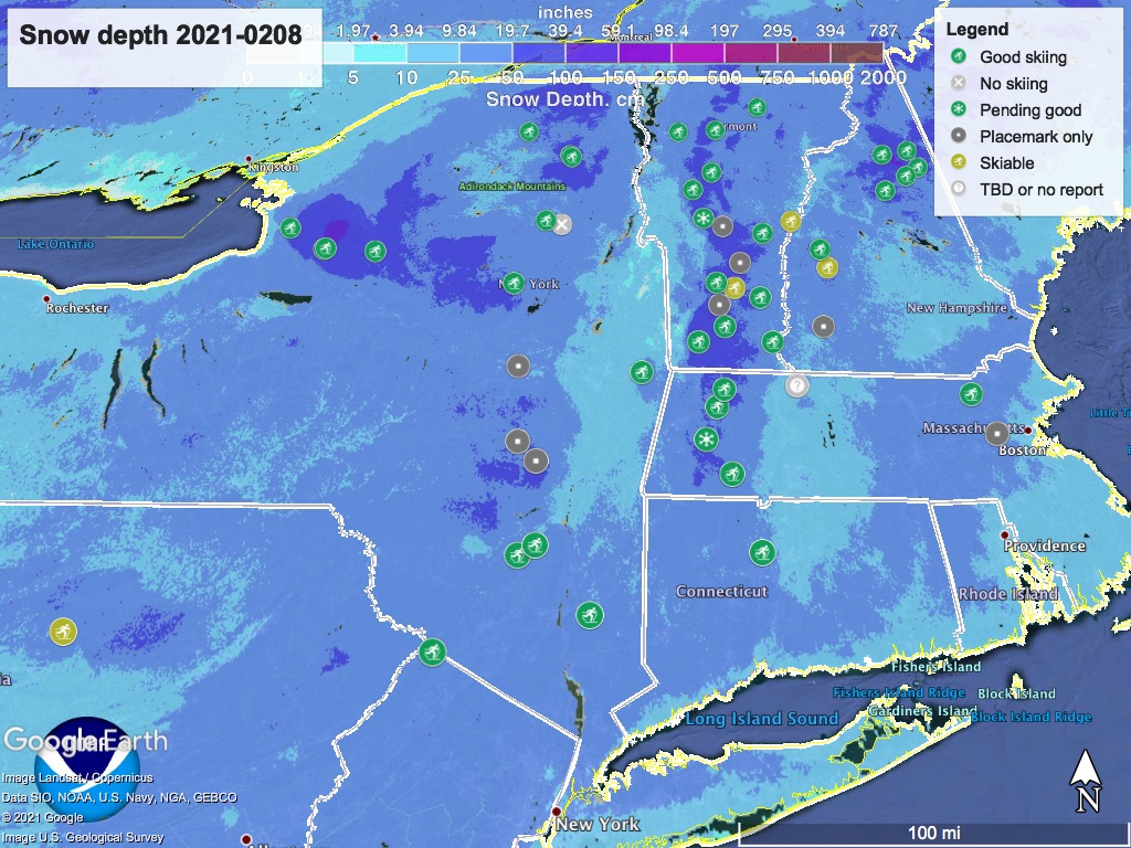
Hit up ‘State of the touring centers‘ or in the menu above for reported conditions. Snow depth graphic below:
Forecast (updated)
Lake effect snow will bring intermittent snow showers to the Tug Hill plateau and the far northern reaches of New York and Vermont though the next several days.
Temperatures trend downward for the rest of the week, with downstate daytime temps on Friday and Saturday in the mid- to upper-20s, low teens to low-20s in the north country and single digits in the Adirondacks, northern Green Mountains, and White Mountains.
There is no major storm in the forecast but predicting the interaction of cold weather in Canada and the movement of warmer air from the south has a lot variability and it looks to stay that way. This much seems guaranteed: much of the northeast will have partly or mostly cloudy conditions and some chance of precipitation through the weekend.
Yesterday (Monday), westerly winds brought colder air from the polar vortex sitting over the Midwest and central Canada. mid-20s to low 30s downstate, mid-30s along the coast. Downstate received a light dusting of snow.
Today (Tuesday) moist air meets cold air, and- a moderate chance of light rain or wintry mix along the coast and southern New England, with snow showers from the mid-Hudson region northward. A slight bump in temperature brings the downstate region and southern New England up to low- to mid-30s; teens to mid-20s in the north country, with some mountain areas in the single digits..
Moderate chances of snow showers early Thursday in the tristate region and northern NJ. Thursay’s high temps will be range from the mid-20s to low 30s downstate. Northern areas will be in the low- to mid-20s, with higher elevations in the teens- mountain areas likely to see single digits.
Moderate chance of precipitation Friday morning for most of New York State, the tristate area and northern NJ. Temps in downstate NY and coastal New England will be in the mid- to upper-20s. Inland and north temps will be teens to low-20s, and single digits in the mountains.
Saturday temps will be much the same as Friday. Probability of precipitation declines as the weekend starts, although snow showers across the region are possible.
Sunday forecast is for a moderate chance of precipitation across most of the northeast. High temps will remain cold in the north country. The Mid-Hudson area should stay below freezing while the downstate area and coastal New England will be in the low-30s.
