
This post contains section links to Conditions and Forecast.
Summary
The conditions at most places are as good as they’ll be for the week. Lake effect plus a bit of additional moisture from westerly winds will bring some additional snow to the Tug Hill plateau and parts of the Adirondacks in midweek.
Backcountry skiing should be good in the Adirondacks and portions of the Green Mountains.
There’s a more contagious variant of SARS-CoV2 out there, and some touring centers are managing capacity by limiting passes. Check in advance, bring a mask while skiing, and equip your car to act as your lodge.
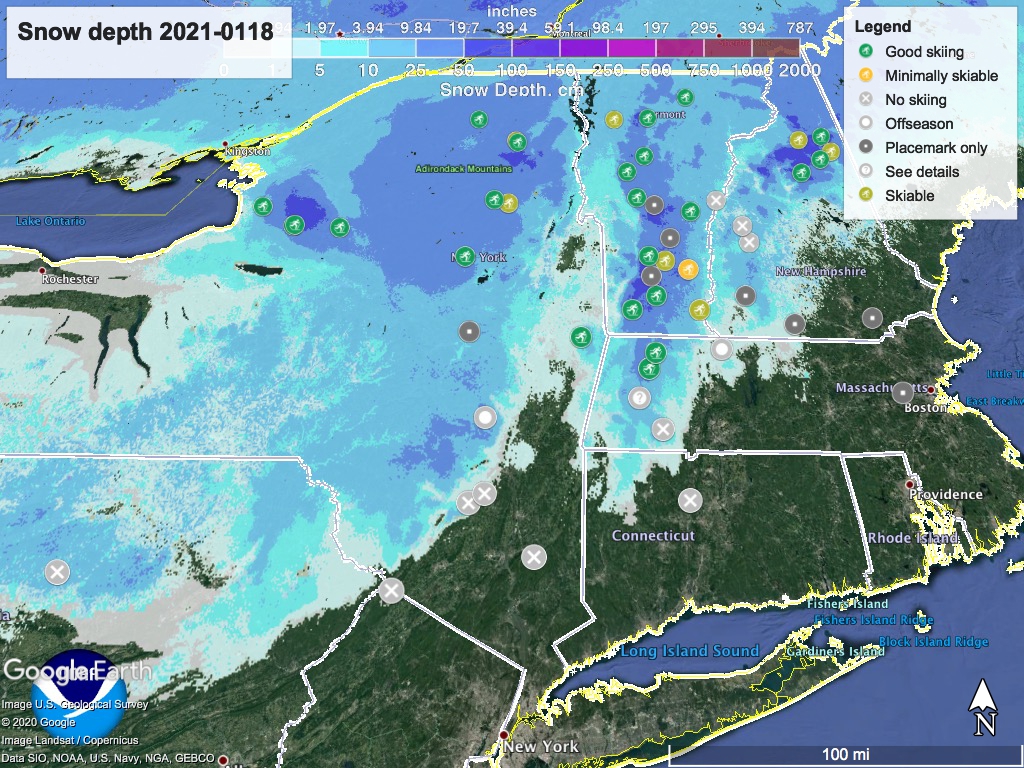
Conditions
The snow event earlier in the weekend brought wet snow, often 6-10″. The Tug Hill and some portions of the Green Mountains got 12″+. Later in the weekend some lucky locations got additional snow that was lighter and less dense. At this point, there’s a good if wet, base that will get firmer and faster as the week goes on. Cloudy skies and some light snowfall during the week will keep things in good shape for next weekend.
Except for us in the downstate region. It’s been just a bit too warm.
BETA report for this week indicates nicely skiable conditions throughout the Adirondacks.
Click ‘State of the touring centers‘ here or in the menu above- it’s been updated for today. Snow depth graphic below:
Forecast
Light snow possible across much of the norther portions of NY State and New England through the week. Moderate snowfall likely Wednesday in the Tug Hill plateau, extending eastward into portions of the Adirondacks. Accumulations could be 4-8″.
Winds generally light and westerly through the week with the exception of Thursday when winds will shift southerly. By Sunday winds will be from the northwest. Clouds will cover most of the region except for the NYC metro, Hudson valley, and southern New England during the week which will be partly cloudy. Skies in the northeast will undergo clearing on the weekend.
Daytime temperatures will be fairly consistent with the past two weeks: in the downstate region, mid-30s to low 40s early and late in the week, low- to mid-30s midweek and Saturday. Temps in north of the downstate and Hudson valley regions will be kinder to snow, mid-20s to mid-30s early and late in the week, teens to mid-20s midweek and Saturday. Sunday the temperatures will stay below 20 degrees in the north country and mountain areas, marking a dip for the early part of next week.
Thanks for reading.
