
This post contains section links to Conditions and Forecast (Updated Saturday Jan. 16 with significant change to weather expected in north country Saturday-Sunday).
Summary
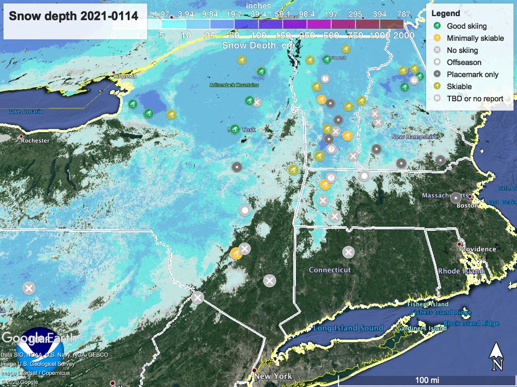
Although some light snow has helped keep bare spots at bay in some mountain areas, many places now calling ‘hard and fast conditions’ due to frozen granular snow and icy spots. Several have the ‘rock skis’ advisory. Those that can make snow and groom really well may have a few k in pristine condition.
On Saturday-Sunday, the Tug Hill plateau, Adirondacks, and mountain areas of VT and NH may get as much as 10-20″ of snow. Much less snow expected in lower elevations. MLK day could be a very good day to ski, particularly in the Adirondacks, Tug Hill plateau, and the higher elevations of New England. Very uncertain as to whether there will be snow enough at Minnewaska to refresh the base.
Conditions
Definitely grading on the curve today (Thursday evening), as most places except for the Tug Hill plateau have been getting starved for snow. Minnewaska has beat all expectations and Upper Awosting remained skiable through Wednesday, but ‘rock skis’ are advised. BETA report as of Thursday indicates conditions are better than we’d expect from downstate.
Today, ‘Skiable’ means it might be hard, fast, and with thin spots, but you can still pick your way through.
Hit up ‘State of the touring centers‘ or in the menu above for reported conditions as of Jan. 14. Some places took a break this week and I expect they might not bother to update till Friday, so they get a ‘TBD’ question mark icon.
Forecast
Clouds today portend precipitation arriving Friday evening. Downstate and in flatlands it will be rain, with some snow possible in mountain areas of NY and New England, as well as central NY and northern PA.
Friday and Saturday daytime temperatures will in the low- to upper- 40s downstate and in the flatlands, and low- to upper- 30s in the northern and hillier areas. Mountain areas might stay just below freezing.
Warm temps in the first half of the weekend will make it hard for snow to accumulate on bare ground, but it might help any existing base. The Friday-Saturday overnight will barely touch below freezing in most spots other than the mountains and northern New Hampshire. Elevation will help some areas get more snow than rain.
[Update Saturday Jan. 16]: major snowfall expected in Tug Hill plateau, Adirondacks, and mountain areas of VT and NH, where 10-20″ could accumulate over Saturday and into Sunday. Much less snow expected in lower elevations
Starting Saturday, a Nor’easter weather pattern brings a modest snowfall event to upstate NY and northern New England. Northern areas are likely to get 2-6″ of snow. The event will continue through Saturday night and into Sunday. Greatest accumulation is likely in the southern Adirondacks and White Mountains of New Hampshire. Microclimates could affect the character of precipitation greatly, and there could be rain even in some areas of the far north.
Temperatures take a dip during Saturday night, going below freezing up north and close to freezing in the NYC metro. Sunday highs will be in the low- to upper- 30s to low 40s in the NYC metro area and 20s to low 30s up north. Good skiing temps, and nights will be cold enough to make snow.
MLK day brings similar temperatures as Sunday, and this looks to continue into the middle of next week. Some light snow might continue on Monday, mainly in central NY, the Tug Hill plateau, and the mountain areas of VT and NH.
[Update Friday]: Next week should stay cool- at or below freezing during the day in most parts north of the mid-Hudson valley at elevation. Along with some possible light precipitation as snow, we might get a refresh of the snow base, potentially setting things up for the Jan. 23 weekend.
