
Update 2/9: SNSA has cancelled the XC ski clinic at Mohonk for lack of adequate snowfall. Not a surprise. ‘State of the Touring Centers’ is slightly updated with reports from Lapland Lake and Waterville Valley. Timber Creek and Northfield Mountain still no report since the storm.
Summary: Good news for people taking a cross-country ski vacation during the school break that starts in a week- conditions in the far north are looking to be set up pretty well for you. As for this weekend or early next week, think about doing an early day trip Sunday or taking a day off Monday. Best-and-closest bets: Pineridge, Notchview, Prospect Mountain.
Terrain in a 3-ish hour drive time received rain, freezing rain, and wet snow on Friday. The drop in temperature overnight solidified the fresh cover to ice, making it tough to groom or ski on. Some crust skiing might be possible later today or once the grooming machinery can get a bite into it. There’s also debris and blowdown from the winds last night.
Just enough new snow to work into the sleet and ice coating from yesterday. That puts us on a skiable powder granular mixture that should imporve as it gets skied in. Cleaning up downed branches from an ice storm as we go along.
Grooming report from Notchview, Saturday Feb. 8
In the 3-4 hr drive time, the picture looks pretty nice:
Updates for today are delayed from: Northfield Mountain, Lapland Lake, and Timber Creek, and Waterville Valley resort. I’ll update conditions once they put something up.
Areas a 4+ hr drive from NYC got more and better snow, sometimes so much it’ll take the day to pack and groom. Conditions tend to be soft today, with some blowdown. Osceola got 22″ of snow over the past three days, and the owner is letting snow settle before grooming, so I’ve listed conditions as ‘Skiable’. But it’s ideal if you want to do a bit of classical light touring in fresh snow.
For real envy, just look at trails and conditions in the White Mountains. As good as they’ve ever been in memory. Nor did the ‘dacks get left in the cold: BETA report from 2/7 for the Adirondack backcountry: ‘All Trails finally skiable’.
We have picked up over a foot of snow on Thursday and Friday. It’s fairly dense snow, so it will more than cover any of the rocks and other hazards we have been warning about so far this season. Saturday will be quite cold with highs only 10-15 degrees, but it warms into the 20s on Sunday. Then warm with light rain or snow on Monday and Tuesday before dropping back below freezing on Wednesday. So, the coming week and following weekend look to be great skiing most everywhere.
BETA trails report Feb. 7
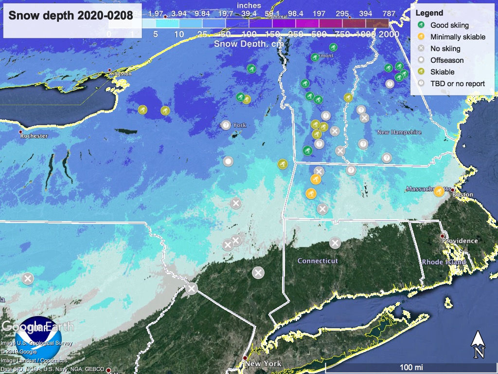
On to the usual business: hit the link or nav menu for ‘State of the touring centers‘. The snow depth graphic is below:
Forecast: Today (Feb. 8) high temps in the far north country and mountains will be in single digits to low teens, 20s to 40s from Albany and Berkshires down to NYC area. Lingering snow showers in isolated areas of the far north.
Sunday much warmer- teens to low 30s in north country and mountains; 30s to low 40s in the Berkshires and Hudson valley/NYC metro. Light snow showers could resume across much of NY and New England, intensifying overnight, before shifting to rain during the day Monday.
Monday through Wednesday, temps range from freezing in the far north to 50s in NYC metro, before cooling off by Thursday. Sunday’s precipitation will shift to rain on Monday before ending in the afternoon. Tuesday, there could be some additional light snow/rain/freezing rain throughout the region.
Another weather front arrives Wednesday afternoon, but the cooling temperatures will allow more precipitation to fall as snow rather than shifting to rain/freezing rain, and these light snow showers could persist through Thursday- Yay! The less good news is that the NYC metro area and mid-Hudson valley will likely be too warm to get much snow out of it.
Thanks for reading.
