

3/9 update
Saturday was the last day for skiing at Fahnestock until/unless more snow comes. Forecast for the coming week doesn’t hold out much hope (just sayin’).
But I have to add that if you managed to get out anywhere today, especially in the morning, the skiing was glorious.
3/8 update
Hang on- the opera for cross-country skiing in our area isn’t quite over yet! Two things are clear in reports from several touring centers within day-trip distance: 1) “conditions Friday are fantastic, but expect trails to get softer and wetter on the weekend”; and 2) “Thin cover. Some bare spots”.
I think some of the downstate areas are repeating their reports from midweek so as not to discourage weekenders. Given that it’s March and in anticipation of warmer weather for the weekend, I’m discounting some of the southerly area status reports a bit for hyperbole.
However, north of Albany and the MA border, skiing’s terrific today and should hold up well for tomorrow too. It’ll be spring skiing going forward.
‘State of the touring centers’ is updated as of 3/8, with the caveat that conditions will change for ones within day-trip distance by end of day tomorrow. Snow depth map (below) will look a lot different by Monday:
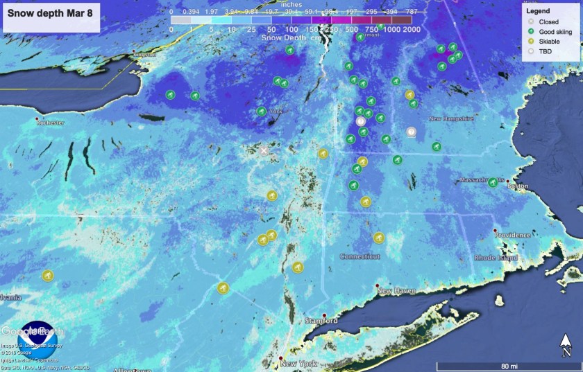
Rain forecast for all downstate and southern New England on Sunday, while the north country of the Adirondacks, Green and White Mtns will see wintry mix or snow. A dip in daytime temp on Tuesday may allow a window for regrooming in areas that still have a base to work with before springtime resumes for later in the week.
Ski Saturday-
[3/7]: If you can’t get out today or tomorrow, Saturday is the day to go. Fahnestock cover is thin, but Minnewaska and Mohonk should hold up. Sunday early to mid-day will be OK in western MA at Notchview and Canterbury with grooming. Pineridge might hang in there. North of Albany and MA, conditions in touring centers like Prospect Mountain and Lapland Lake should easily hold up all the way into the early part of next week, when daytime temps there will drop back to low- to mid- 30s.
On the other hand, if you can get out there, here’s some quotes from the groomers on conditions as of Thursday 3/7:
Wow Just Wow! Incredible packed powder skiing
Northfield Mountain
We have the best skiing all winter, and it looks like it will last through the weekend
High Point
Solid base with 6 inches of fresh packed powder will be the best skiing yet this season
Canterbury farm
I’ll update this post on conditions and state of touring centers across the Northeast late today or on 3/8 to get accurate updates ahead the weekend.
Outlook for the weekend and beyond-
In our region there’s a chance of light snow Friday into early Saturday. Daytime temps for downstate NY and lower Hudson Valley: low 30s on Friday, low 40s on Saturday.
Rain arrives on Sunday- in the Hudson Highlands and Shawangunks the precipitation could start as snow/sleet with some accumulation before changing over by mid-day. North of the Gunks and in northern New England, it may continue as snow all through Sunday, with a late-day changeover to rain in western MA.
In the first half of next week, temps fall somewhat- by Tuesday we will see daytime highs of mid-40s in the NYC area, and low 30s in the Catskills and northward.
