
We’re down to the last a handful of places,:
- Oak Hill Outdoor Center
- The Dublin School Nordic Center
- Rikert
- Bolton Valley Nordic Skiing & Snowshoeing
- Craftsbury Outdoor Center
- Trapp Family Lodge
- Jackson Ski Touring
- Waterville Valley resort
- Mt. van Hoevenberg
- Paul Smith’s VIC
- Gore Mountain
- Lapland Lake
- Osceola Tug Hill
Most of these have minimally skiable conditions, and some are going offseason after Sunday. A few die-hards like Lapland Lake and Rikert are predicting they’ll make it into April.
This post is about conditions for Mar. 28 2026, and forecast for the next few days. See jump links to Conditions and Forecast.
What will the skiing be like?
Conditions recap: with rises and dips in temperature over the last week, anyone would be forgiven for wondering whether to commit to a drive for skiing. Yet some slight refreshes of snow and really really good grooming kept things in decent condition at places in the far north, including Paul Smith’s VIC, von Trapp Family Lodge, Lapland Lake, and Waterville Valley.
This weekend there’s some hard ice in the mornings, with spring conditions later as long as the groomers continue working on the trails. The above are among the ones that have some skiable terrain now. But let’s face it, when the ski conditions report says ‘enjoy your ski or snowshoe‘, you know conditions are pretty marginal.
Hit up ‘State of the touring centers‘ or in the menu above for reported conditions as of today. Snow depth graphic below:
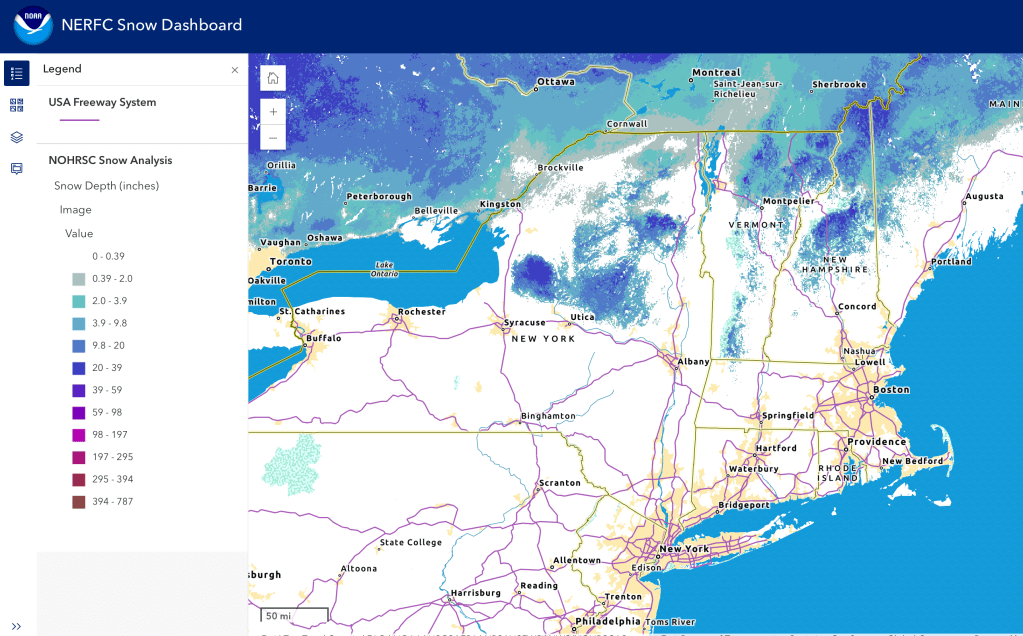
The snow depth map above shows why Lapland Lake still has some skiing but Garnet Hill had to close trails for the season. The remaining bits of snowpack are concentrated in small portions of the High Peaks, northern Greens and NEK, and the White Mountains. Wonder what’s just north of Syracuse and Utica that might be skiable too.
Upcoming weather
Weather recap: Hide-and-seek spring skiing. Occastional dustings of snow helped put a bit of skiable cover on hard crust and ice, and made for some nice conditions in super-comfortable weather, IF you could find the reight place.
Summary: Slightly cool spring weather starts off the weekend, becoming very spring like toward midweek before dipping again along with a promise (no guarantees) of a bit of snow. That slight refresh might give a chance of a last ski in some areas late in the week.
Day-by-day details:
Light lake effect snow for the Tug Hill Saturday. Otherwise clear wather for the weekend. A bit breezier on Saturday (10-20mph), milder on Sunday, generally from the west, but with some gusts of 30+mph in the southern western areas of the Northeast-US on Saturday. Gustiness moderates on Sunday.
System develops late Monday, with rain showers moving across the Northeast-US on Tuesday. Heavier rain in the norhtern areas. Winds shift southerly or to the SW, generally calm (10-15mph) with fiew gusts.
Heavier rain advances southward on Wednesday, and rain showers up north could convert to snow as a cold front moves in late Wednesday. As could be expected, winds start southerly and turn northerly by late in the day. Still mostly mild, (10-20mph), with some gusts of 25-30mph, particularly towards eastern MA.
Snow showers may persist across the Adirondacks, Vermont, and New Hampshire on Thursday, with some snow as far south as the Berkshires. Wintry mix at the rain/snow line, and rain showers in the southern portion of the Northeast-US. Winds become milder at around 10-15mph, slightly higher in gusts.
On Friday the snow showers up north may retreat being replaced by wintry mix, while rain or rain showers continue down south. Winds remain calm.
| Date / Daytime high temp | Mountains in northern NY, VT, and NH | Lowlands from central NY to NH interior | Hudson Highlands to NYC metro |
| Sa 3/28 | Single digits to teens | Mid 20s to mid 30s | Low to mid 40s |
| Su 3/29 | 20s to low 30s | 40s | Upper 40s to mid 50s |
| Mo 3/30 | 30 to low 40s | 50s | 60s |
| Tu 3/31 | Upper 30s to upper 40s | Upper 50s to upper 60s | Mid 60s to mid 70s |
| We 4/1 | 40s | Low 50s to mid 60s | 70s |
| Th 4/2 | 20s to 30 | Upper 30s to mid 40s | Upper 40s to low 50s |
| We 4/3 | Mid 30s to mid 30s | Low to mid 40s | Mid to upper 40s |
AI-generated forecast summary, from NWS forecast discussions.
Copy/paste from MS Copilot summary. Take it for what it’s worth. I’m testing to validate what works best. It’s a decent narrative construct, no blatant inaccuracies or fictions.
1. Today (Saturday): Cold, Breezy, Scattered Snow Showers
- Temperatures:
- Highs: 20s–30s (coldest in higher terrain; mid–upper 30s farther south).
- Snow:
- Scattered convective snow showers across all regions.
- Light accumulations: coating to 1″ (highest in Tug Hill, western Adirondacks, northern Greens).
- Lake-effect influence for BUF and ALY north of I‑90.
- Winds:
- W/NW winds 20–30 kt gusts common (especially Mohawk Valley, Capital District, Berkshires, Champlain Valley).
2. Tonight: Clearing, Very Cold
- Snow showers diminish quickly after sunset.
- Lows: 10s–20s regionwide.
- Light S/SW flow develops late.
3. Sunday: Quiet, Moderating
- Dry, mostly sunny.
- Highs: 30s north → upper 40s south.
- Breezy at times but less harsh than Saturday.
4. Monday: Transition Day — Increasing Clouds, Mild
- Warm advection begins.
- Highs: 40s–50s (milder south of I‑90).
- Mostly dry; a few showers possible late (mainly ALY/GYX).
5. Tuesday–Wednesday: Warm, Wet, and Unsettled
This is the major weather event of the week.
- Warm Front + Strong SW Flow
- Temperatures surge:
- 50s–60s widespread,
- Low 70s possible in the Mid‑Hudson Valley and western CT (ALY).
- Temperatures surge:
- Rain:
- Periods of rain likely across all regions.
- Some embedded thunder possible (BUF, ALY).
- Hydrology:
- Rain + snowmelt may cause river rises, especially in the Adirondacks (ALY).
- Current flood probabilities remain low, but not zero.
- Aviation:
- MVFR/IFR likely at times.
6. Late Week (Thu–Fri): Cooler, Then Another System
- Cooler air returns Thursday (highs upper 30s–40s).
- Another system likely Friday into Saturday with additional precipitation.
- Precip type uncertain (rain/mix/snow possible depending on track).
🧩 Regional Character Snapshot
| Region | Today | Early Week | Tue–Wed | Late Week |
|---|---|---|---|---|
| Western and central NY to Tug Hill | Lake-effect snow, cold | Warming | Warm, rainy, possible thunder | Cooler, dry then unsettled |
| Catskills, Berkshires, southern VT | Breezy, isolated snow | Dry, warming | Warm front → rain, 70s possible | Cooler, next system late |
| White mountains, NH, southern ME | Cold, scattered snow | Moderating | Damp, showery | Cooler, unsettled late |
| Northern NY and VT | Convective snow showers | Quiet, warming | Warm, rainy, strong SW flow | Cooler, uncertain precip |
