
Skiable conditions have retreated to the far north, and only for specific locations at that. Best choices of touring center trails for the coming week are:
- Lapland Lake
- Paul Smith’s VIC
- von Trapp Family Lodge
- Rikert
- Waterville Valley
- Great Glen
Mt. van Hoevenberg trails closed to the public for the last World Cup race of the season today (Sunday). No telling if they’ll reopen for skiing to the public after the weekend.
This post is about conditions for Mar. 22 2026 and forecast for the next few days. See jump links to Conditions and Forecast.
What will the skiing be like?
Skiable conditions this morning, rain by afternoon or evening. Rinse and repeat. I’ve skied in the rain, but it’s always been because I’ve made too much of a commitment in time and effort not to go out and at least try. Sometimes you just say to yourself: ‘Maybe I’ll watch the World Cup instead on OutsideTV’.
The OutsideTV link stopped working once the race was over. Instead I’ll point to the FIS highlights. First, for the men’s race:
And for the women’s race, the finale for the World Cup season and the last of Jessie Diggins’ career (for now?). Congrats to Jessie, thanks for the good vibes, and may the wind be at your back for whatever comes next!
Finally, an interview of Jessi Diggins by NBC Sports, with a pair of custom-printed Saolomon skis:
Back to our regularly scheduled programming. These areas report conditions that merit ‘my label as skiable’ (reasonable amount of trails/terrain ready for skiing without significant hazards):
- Paul Smith’s VIC
- Lapland Lake
- Craftsbury Outdoor Center
- Trapp Family Lodge
The following hope to get some snow later today or early in the week and reopen trails:
- Scotts Cobble
- Osceola Tug Hill
- Marlboro Nordic Ski Club
- Prospect Mountain
- Great Glen Trails
After today Mar. 22, the following will close for the season:
- Blueberry Hill Outdoor Center
- Mountaintop Inn and Resort
- Wild Wings
Hit up ‘State of the touring centers‘ or in the menu above for reported conditions as of today. Snow depth graphic below:
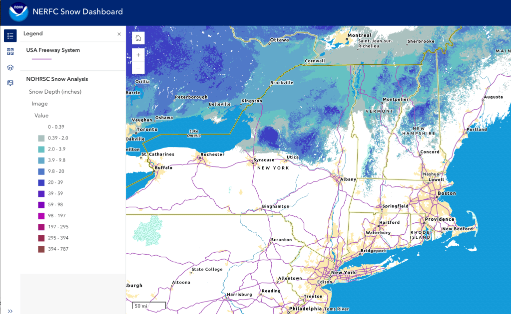
Snow cover depth is as of early Sunday morning- but there’s been spotty across a good part of the Northeast-US, and more expected for the day.
Upcoming weather
Weather recap: a pretty epic meltdown over the last two weeks did not get a reprieve this weekend. There had been some thought of a ‘colder solution’ that could have meant more snow, but the warm ‘nose’ of moisture from the south spoiled the party. While there was a pretty significant amount of snow in Lake Placid on Friday, it rained Friday night.
Summary: fronts coming through today into Monday, midweek, and Friday, with opportunities for an inch or two of snow in each, but also rain depending on location and how the systems interact. A cold front moves in from the northwest by Wednesday. The front at the end of the week will sweep in from the west, but potential for precipitation is undetermed. It’s springtime!
Details for the week:
Today (Sunday): warm moist air in the southern portion is causing rain showers through to northern New York and New England. At elevation, some snow is falling. Potential freezing rain or wintry mix in mid-northern areas at elevation. Rain may convert to snow later tonight before ending, as colder air works it’s way into the region. Winds very mild. LThe last World Cup feel like they’re in Trondheim, and indeed it appeared to be slow going on the downhills.
Monday, colder air arrives, and precipitation may continue toward the northern and eastern regions of the Northeast-US, as snow and also some version of wintry mix or rain. Possible freezing rain could make for some hazardous driving. Winds shift northerly and mild overall, but with some gusts of 25mph in the NYC metro and coastal mid-Atlantic.
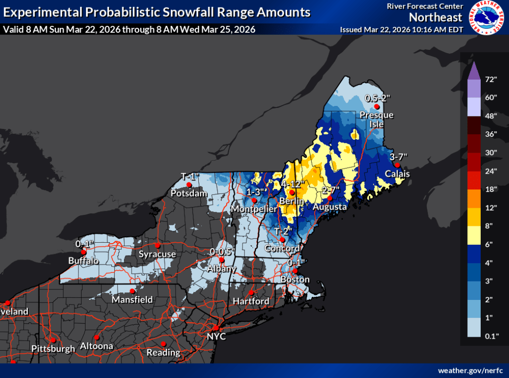
Midweek and later in the week, tempertures will moderate, and additional systems will generate precipitation. Amounts appear to be slight for now, and type will vary by region, elevation, and time of day. Precipitation gradually clearing at the end of the week.Winds will shift westerly for midweek, and southerly on Thursday. Gusts will occastionally rise to 20mph. For tbe end of the week winds will shift back to westerly or WNW, with increasing gustiness to 25-30mph in the souther regions.
The start of the weekend should be mostly sunny with late winter/early spring temperatures. Winds will be very mild again, with little gustiness.
| Date / Daytime high temp | Mountains in northern NY, VT, and NH | Lowlands from central NY to NH interior | Hudson Highlands to NYC metro |
| Su 3/22 | 20-30 | 30s | Mid 50s to mid 60s |
| Mo 3/23 | Teens to low 20s | Upper 20s to upper 30s | 40s |
| Tu 3/24 | Teens to upper 20s | Upper 30s to mid 40s | Upper 40s to low 50s |
| We 3/25 | Teens to mid 20s | Low 30s to low 40s | Low to mid 50s |
| Th 3/26 | Low 20s to mid 30s | 40s | Mid to upper 50s |
| Fr 3/27 | Teens | Mid 20s to mid 30s | Upper 40s to low 50s |
| Sa 3/28 | Teens to low 20s | Upper 20s to mid 30s | Low to mid 40s |
AI-generated forecast
As with the last time, copied and pasted a portion of Copilot generated summary of NWS forecast discussions for relevant areas of the Northeast-US. Note that this was done Sunday, but Copilot thought it was Saturday. All the forecast discussions wereh updated Sunday morning. It is true that the forecasts didn’t go much beyond Tuesday, although some mentioned two more fronts, arriving Thursday and Friday. I give AI an ‘incomplete’ for this one.
🧩 Integrated Regional Summary
Precipitation
- Today–Saturday:
- Light, elevation‑dependent snow across northern zones (Adirondacks, Greens, Whites).
- Rain or rain/snow mix in valleys and southern areas.
- Sunday–Monday:
- More organized system with widespread precip:
- Snow → rain → snow for many areas.
- Heaviest QPF likely in VT/N NY.
- More organized system with widespread precip:
Temperatures
- Near or slightly below normal early week.
- Brief warmups ahead of each system.
- Colder air returns Monday–Tuesday.
Winds
- Gusty south winds today (ALY).
- Breezy/windy Friday south of Lake Ontario (BUF).
- Stronger winds possible Sunday–Monday (BTV).
📊 Quick Regional Comparison Table
| Region | Today–Sat | Sun–Mon System | Temps | Winds |
|---|---|---|---|---|
| Mid-northern NY, western MA, southern VT | Light snow north; rain/mix south | Rain → snow | 30s–40s | Gusty S today |
| Northern NH, southern ME | Snow north, rain south; 2–5″ mountains | Mostly snow; mix south | 30s–50s | SCA offshore |
| Northern NY and VT | Light rain/snow; 6″ high peaks | Snow → rain → snow; windy | 30s–40s | 30–45 mph possible |
| Western and central NY to Tug Hill | Rain; snow at onset N | Rain or mix; colder after | 30s–40s | 30–35 mph Fri |
