
[Update Friday 3/20] The reprieve some of us are hoping for might arrive, at least in the northern reaches. See updated Forecast with snowfaall totals through Mar. 23 below. Also, an AI forecast summary test.
Well s**t. It’s mighty thin cover in most of the Northeast-US, and not much expectation for a reprieve unless forecasters are wrong about a system due to form up for late in the weekend.

But it’s also World Cup weekend in Lake Placid, and there’s still some snowpack! The Tug Hill has good cover, and expects some lake effect snow. A couple of places in the Adirondacks still have some cover to work with, as does Prospect Mountain, and it looks like Jackson and Waterville Valley that are getting some terrain into shape.
You have to know that Mt van Hoevenberg has left nothing to chance. Listen to Kris Cheney Seymour describe their work and hopes for this set of events in an interview with North Country Public Radio.
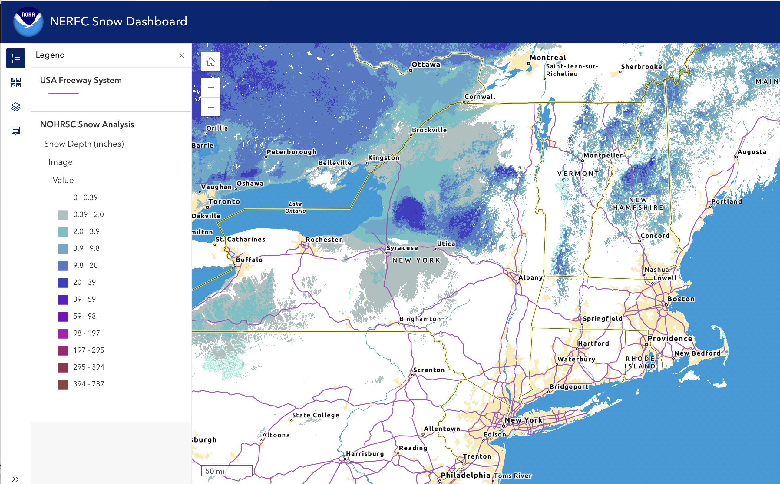
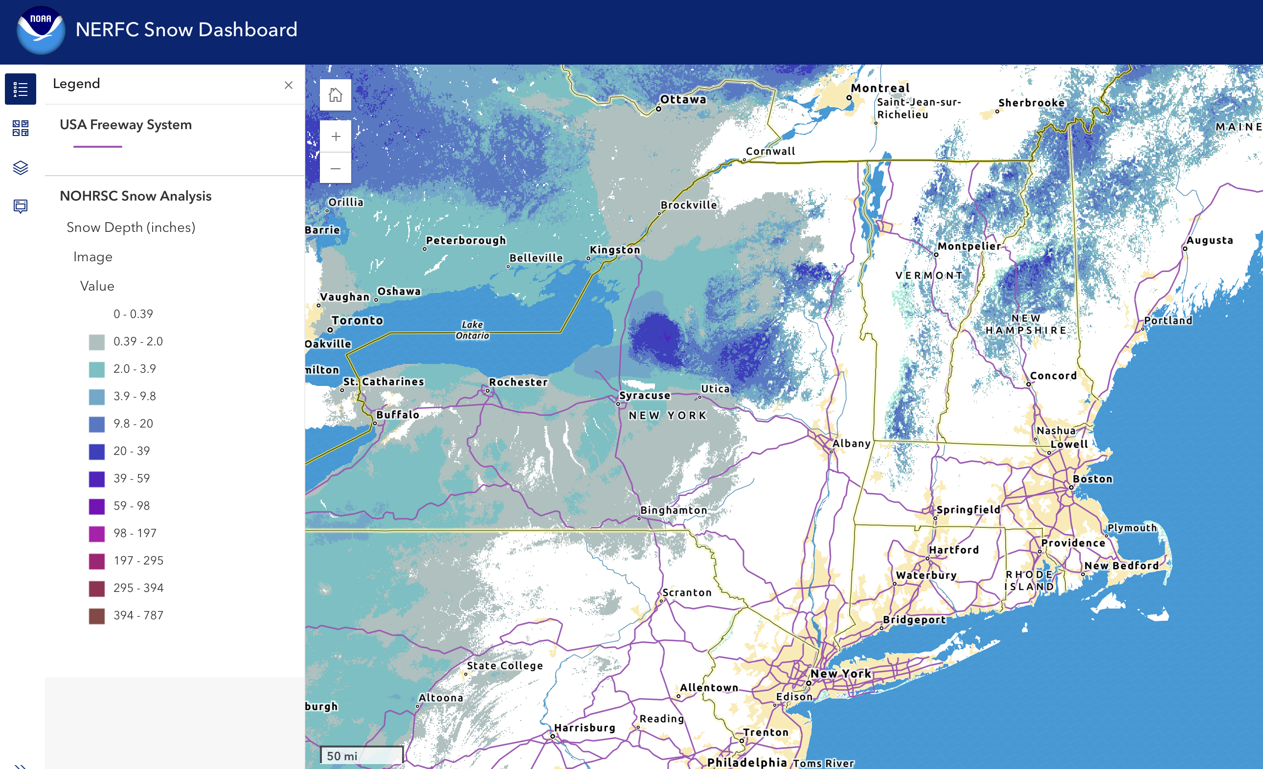
This post is about conditions for Mar 19, and forecast for the next few days. See jump links to Conditions and Forecast.
What will the skiing be like?
With the return of subfreezing nights, the damp snowpack turns to ice by morning. This is not fun to groom or to ski. East of the Hudson, places that want to groom are having to make multiple passes. In the western portion of the Northeast-US repeated lake effect snow has helped cover the boilerplate ice. Spring conditions indeed, with some ice and bare spots.
Color the conditions as ‘variable and challenging’, with some wet and damp conditions toward the west where rain has fallen on Friday, to light snow on ice in northern Vermont, and granular or icy with bare spots elsewhere.
It might be sparse staffing and skier traffic too, as some folks are heading for Lake Placid for the World Cup races. Besides Mt van Hoevenberg trails being partially closed off for recreational use, traffic will be pretty bad in the area.
By last weekend or this week, several places either called it a season are ready to do so:
- Notchview Reservation
- Stump Sprouts
- Brattleboro Outing Club
- Grafton Trails
- Viking Nordic
- Green Woodlands
- Bretton Woods Resort
In the wings for their last arias are Marlboro Nrodic Ski Club and Great Glen, who might decide against reopening, and Mt. van Hoevenberg, whose report today made it sound like they’ll close it up after this weekend. Wild Wings might be next, and Garnet Hill’s conditions don’t sound wonderful.
Hit up ‘State of the touring centers‘ or in the menu above for reported conditions as of today. Snow depth slideshow of yesterday and today’s snowpack below:
Upcoming weather
Thursday a small system brings light snow or snow showers in the far north. Winds will be a bit breezy at times on Thursday and Friday, going up to 20mph in some parts. All told no real accumulation expected. Winds calm overall.
Light snow for the north for a short time on Friday, expected to change to mostly rain or rain showers and overspreading the Northeast-US late in the day. No significant accumulation expected, and subsequent rain might wipe out any snow except at the higher elevations. This systrm will depart on Saturday. Winds begin to shift westerly on Saturday, increasing but still mild, with gusts only to about 20-30mph except the Massachusetts shore where stonger gusts are expected.
Another system brings precipitation early Sunday. This system will likely be more consequential than the previous ones and will last into Monday. There could be more of a mix of snow than rain and wintry mix in the middle-north. There will periodic shifts in precipitation type, as winds start shifitng from weesterly to north and northwesterly. Still some uncertainty in forecasts as to amounts of rain vs snow, although forecasts have started to predicts several inches of snow at the higher elevations. Isolated gusts late in the weekend into Monday could be 20-25mph.
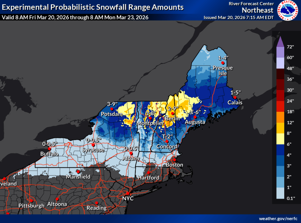
Cooler than normal temps continue fromMonday into Tuesday, Tueday should by dry. Potential for light snow showers or wintry mix in the far north on Wednesday, with wintry mix/rain in the south. Winds from the north early next week, shifting westerly and to the WSW for Wednesday. A bit breezy at times in the midweek, but generally calm winds.
Long-range 6-10 and 8-14 day temps are somewhat likely to be cooler than normal, according to the NOAA Weater Prediction center.
| Date / Daytime high temp | Mountains in northern NY, VT, and NH | Lowlands from central NY to NH interior | Hudson Highlands to NYC metro |
| Th 3/19 | Teens to low 30s | Upper 30s to low 40s | 40s |
| Fr 3/20 | Mid 20s to low 30s | 40s | 50s |
| Sa 3/21 | Mid 20s to low 30s | 40s | Upper 50s to low 60s |
| Su 3/22 | Mid to upper 20s | Mid 30s to mid 40s | Upper 50s to mid 60s |
| Mo 3/23 | Teens to mid 20s | Low 30s to 40 | Mid 40s to 50 |
| Tu 3/24 | Teens to mid 20s | Low 30s to 40 | Mid 40s |
| We 3/25 | Teens to upper 20s | Low 30s to mid 40s | Upper 40s to low 50s |
AI forecast summary test
Another AI trial. This time instead of asking MS Copilot to do data extraction and transformation, I just asked it to summarize the zone forecasts from the text of different NWS offices of the Northeast-US. I took some content and pasted as is below, with light adds/edits for clarity and context. I used the same information plus some other pages with NWS data visualizations for my own forecast above.
🌧️❄️ Sunday–Monday System
Uncertain and potentially impactful system:
- Track uncertainty affects rain vs. snow (for northern areas from upstate/central New York state to Vermont).
- Warmer solutions favor more rain (affecting the above).
- Colder solutions bring more snow, especially higher elevations (for northern New Hampshire and Vermont).
- Potential for 30–45 mph winds in northern areas (Adirondacks to northern Vermont).
- Widespread measurable snow likely in ME/NH (based on Portland NWS forecast).
💨 Wind
- Friday: Breezy/windy south of Lake Ontario (BUF), gusts 25–30 kt near NYC.
- Sunday–Monday: Stronger winds possible in VT/Northern NY.
📍 Regional Summary Table (next seven days)
| Region | Key Weather Themes | Precipitation | Temperatures | Notable Impacts |
|---|---|---|---|---|
| NYC / Coastal SNE (OKX) | Warming trend; two weak systems; mainly rain | Rain late Fri → early Sat; Rain again Sun PM–Mon | Highs upper 40s–60s through weekend | Minimal impacts; breezy Fri PM; cooler Mon |
| W. & N‑Central NY (BUF) | Multiple systems; colder early next week; windy Fri | Rain Fri (snow N Country at onset); Rain/snow Sun–Mon | Warm Fri–Sun; colder Mon onward | Gusts 30–35 mph Fri; lake‑effect snow Mon |
| Northern NY & VT (BTV) | Warming through weekend; three systems; active next week | Light mix Thu night; Rain/snow Fri–Sat; Rain/snow/wind Sun–Mon | Highs upper 30s–40s; colder next week | High‑elevation snow Fri–Sat; strong winds Sun–Mon |
| W. ME & N. NH (GYX) | Snow this afternoon/evening; colder active pattern next week | Snow north; rain south today; Snow Sun night–Mon | 30s–50s today; colder next week | 2–5″ snow mountains today; slick evening commute |
| Eastern NY & Berkshires (ALY) | Parade of clippers; mixed precip; wet start to next week | Rain/snow Fri; Rain/snow Sun–Mon | 40s–50s Fri; cooler next week | Slick Fri AM north/west of Albany; prolonged precip Sun–Mon |
