
[Update Tuesday 3/17] Heavy rains last night left a lot of water to drain out of what remains of the snowpack (not much remains though). Cold weather today isn’t helping because if trails aren’t groomable due to dampness, they’re hard to groom because they’re icy. State of the Touring Centers has been updated with Tuesday’s reports.

Looks like the World Cup races in Lake Placid are well-timed as a possible last aria for the 2025-26 XC ski season. Mother Nature might always surprise us, but in terms of touring center operations it may not be worth the trouble, given the work needed for springtime.

There’s just not any great place to ski in the rain, and that’s what most of the Northeast-US is going to get today.

This post is about conditions for Mar. 16 2026, and forecast for the next few days. See jump links to Conditions and Forecast.
What will the skiing be like?
Conditions recap: soft, slushy, icy spring conditions best enjoyed in the woods rather than open fields. The past weekend was the last run for some places that decided to call it a season, including Bretton Woods.
We’re running on fumes now. Things at this late stage in the season are such that the places that have closed trails temporarily are also not sounding optimistic that they’ll get enough new snow to reopen them. Not to mention that the trusty grooming and maintenance crews are not into making a huge effort for the chance of a few more days of skiing pleasure.
You can hear a season’s worth of work in one short but honest post:
I’m not going to grrom today. You can fat bike it as it is, if you like this morning. It may also soften enoungh by mid-day for a back country type ski.
Although there remains 8 – 14″ base pretty consistently on most wooded trails, the occasional washouts would require a fair amount of work to patch up enough to get the groomer through. With rain coming on Monday and a shoulder than needs a rest, I’m going to pass on this one.
Stump Sprouts trail report Sunday 3/15/26
Give it up for the groomers – they make it our fun pastime a lot easier to enjoy.
Hit up ‘State of the touring centers‘ or in the menu above for reported conditions as of today. Snow depth slideshow graphis below:
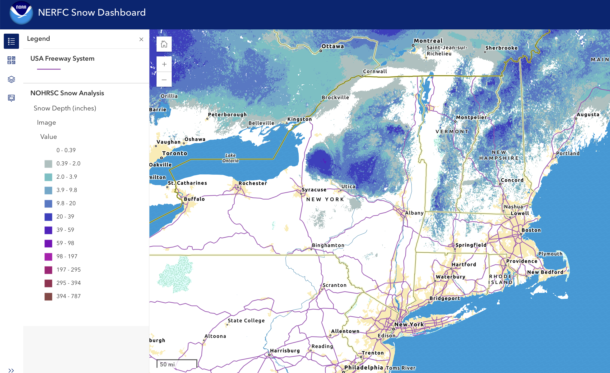
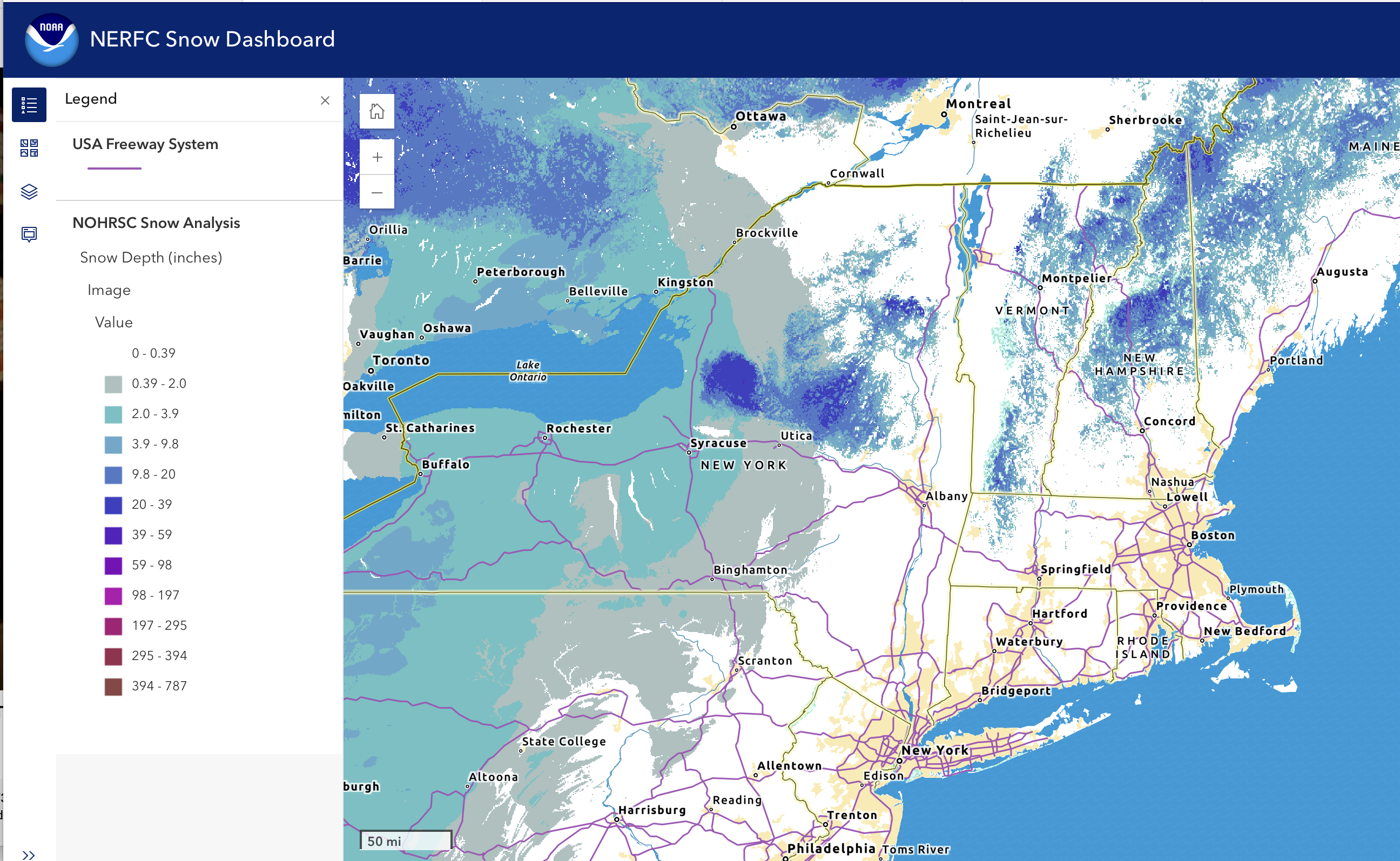
The scant snowfall yesterday went to the lucky folks around Syracuse NY. Elsewhere the rain continued to hammer the snowpack. The return of colder weather will now make grooming even more important, as any remaining base will become icy-hard overnight. Any refresh of sn ow would be helpful, and there might be a bit toward the end of the week. It’s rock skis for sure to the end of the season.
Upcoming weather
Weather recap: warm weather and rain have depleted the snowpack, and the small refershes of snow have been no match so far. But there’s still a bit of life left tin the comatose ol’ man winter yet. There have ben some gusty winds, particularly in the southern and coastal regions.
Day-by-day:
Precipitation ends early Tuesday, with some of the last remnants converting to snow showers in the north as colder air arrives from the west and daytime temps drop about twenty degrees compared to Monday. At least a few inches of lake effect snow will fall across the Tug Hill and northern NY state, with some lesser amounts in the Adirondacks. Wind gusts quiet down but still breezy, and gusts will still be up to 30-35mph in the lowlands and 35-40mph at elevation.
Wednesday will be dry and cold, with mild westerly winds and little gustiness. Mostly sunny on this day, possibly the nicest one for the week to be outside.
Thursday will start with some light snow across northerm parts of NY state, Vermont, and New Hampshire, as winds shift southerly bringing moist air in. As the day goes on, rain showers will arrive for the western and southernmost parts of the Northeast-US and the Hudson valley. The rain/wintry mix/snow line with shift back-and-forth throughout the day. Winds will be a bit breezy at times on Thursday and Friday, going up to 20mph in some parts. All told no real accumulation expected.
The pattern of northern snow showers/southern rain showers will continue into Friday and the weekend, as will periodic shifts in precipitation type, as winds start shifitng from the west and WNW. Given that night time temps north of Albany and the VT-NH/MA border will be below freezing, there’s a reasonable chance to pick up some accumulation in the norther regions of the Northeast-US. Gustss will get a bit stronger over the weekend, rising to 30+mph in isolated areas.
Cooler than normal temps continue into Monday, and precipitation ends. Gustiness continues at similar levels to Sunday, shifting northwesterly.
| Date / Daytime high temp | Mountains in northern NY, VT, and NH | Lowlands from central NY to NH interior | Hudson Highlands to NYC metro |
| Mo 3/16 | Mid 40s to low 50s | Upper 50s to low 60s | Low 60s |
| Tu 3/17 | Teens to 20 | Low 20s to low 30s | Upper 30s to low 40s |
| We 3/18 | Teens | Mid 20s to mid 30s | Upper 30s to low 40s |
| Th 3/19 | Teens to low 30s | Upper 30s to low 40s | 40s |
| Fr 3/20 | 20s | Mid 30s to mid 40s | 50s |
| Sa 3/21 | 20s | Mid 30s to mid 40s | Low 50s |
| Su 3/22 | 20s | 30s | Mid to upper 40s |
| Mo 3/23 | Teens to low 20s | Upper 20s to mid 30s | Mid to upper 40s |
