
Never say never even in mid-March, but the four nearby touring centers have closed trails for skiing or opened them for hiking by the end of the weekend or early in the week. Absent a significant snowstorm they won’t be restarting the grooming machines.
The closest survivors with skiable groomed trails: Prospect Mountain, Notchview, Lapland Lake
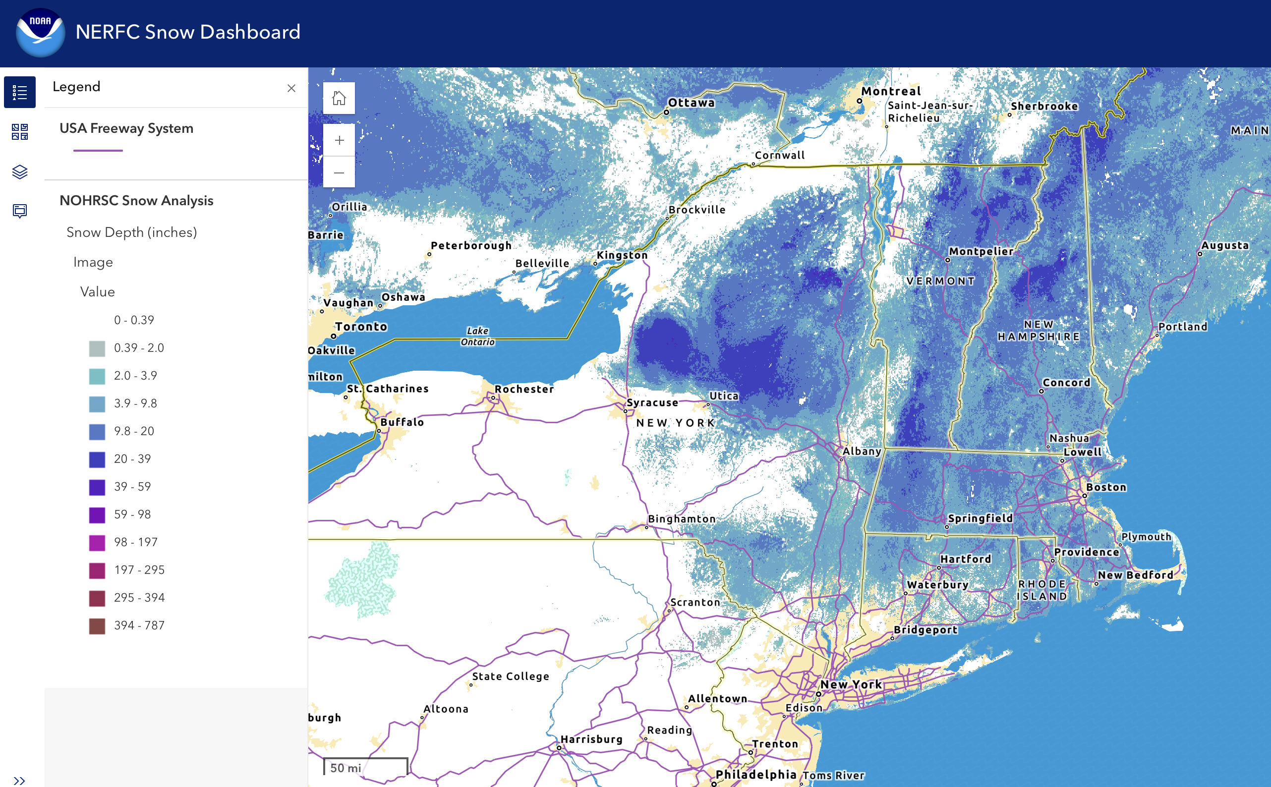
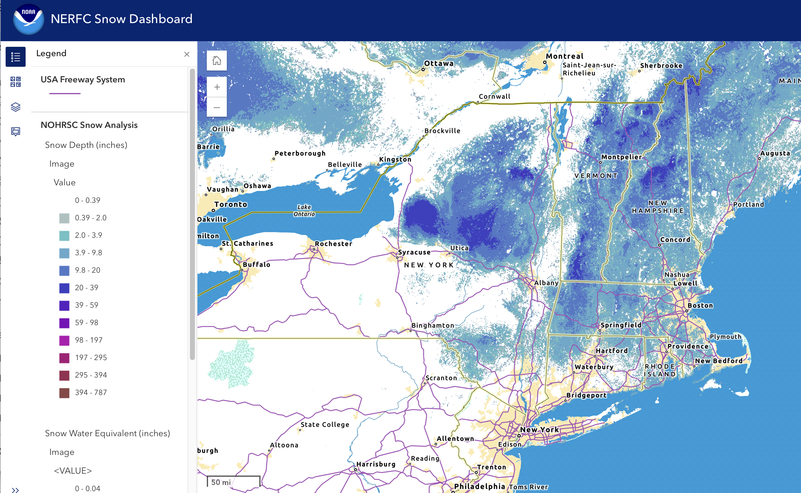
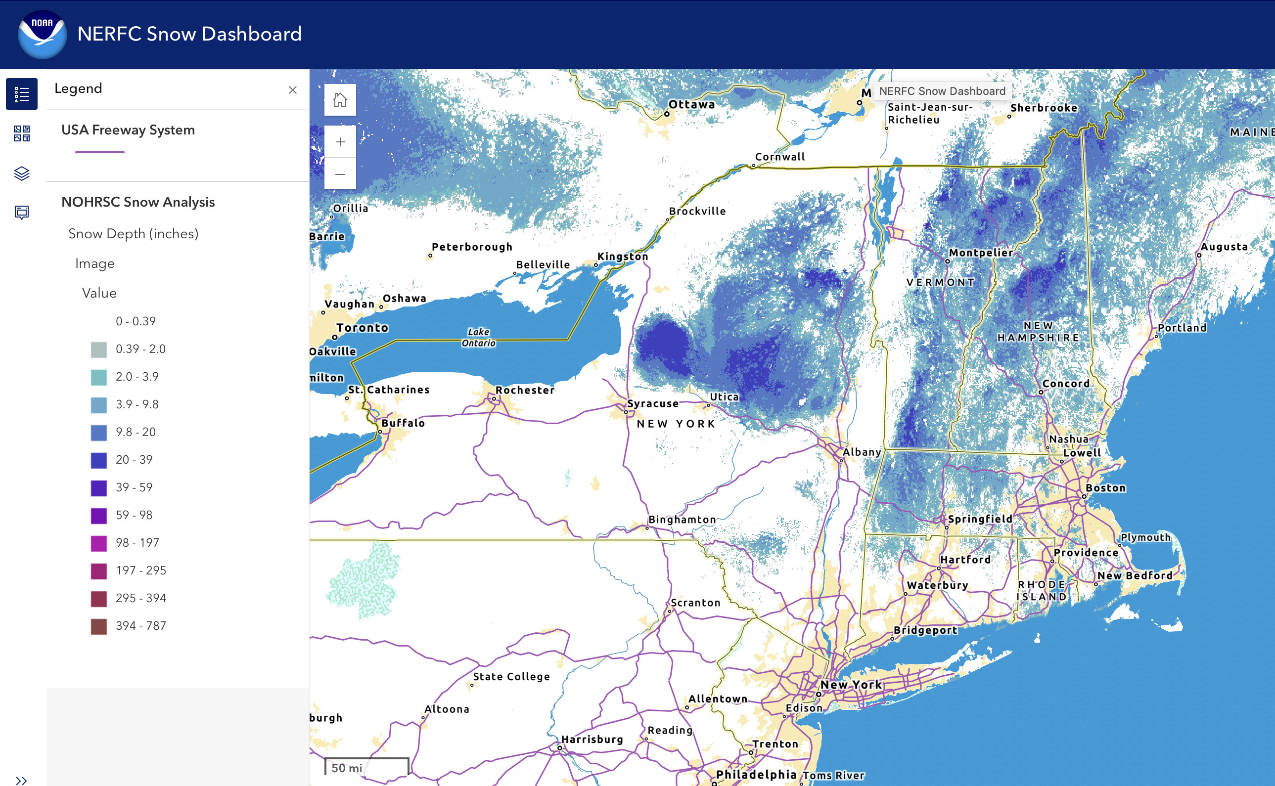
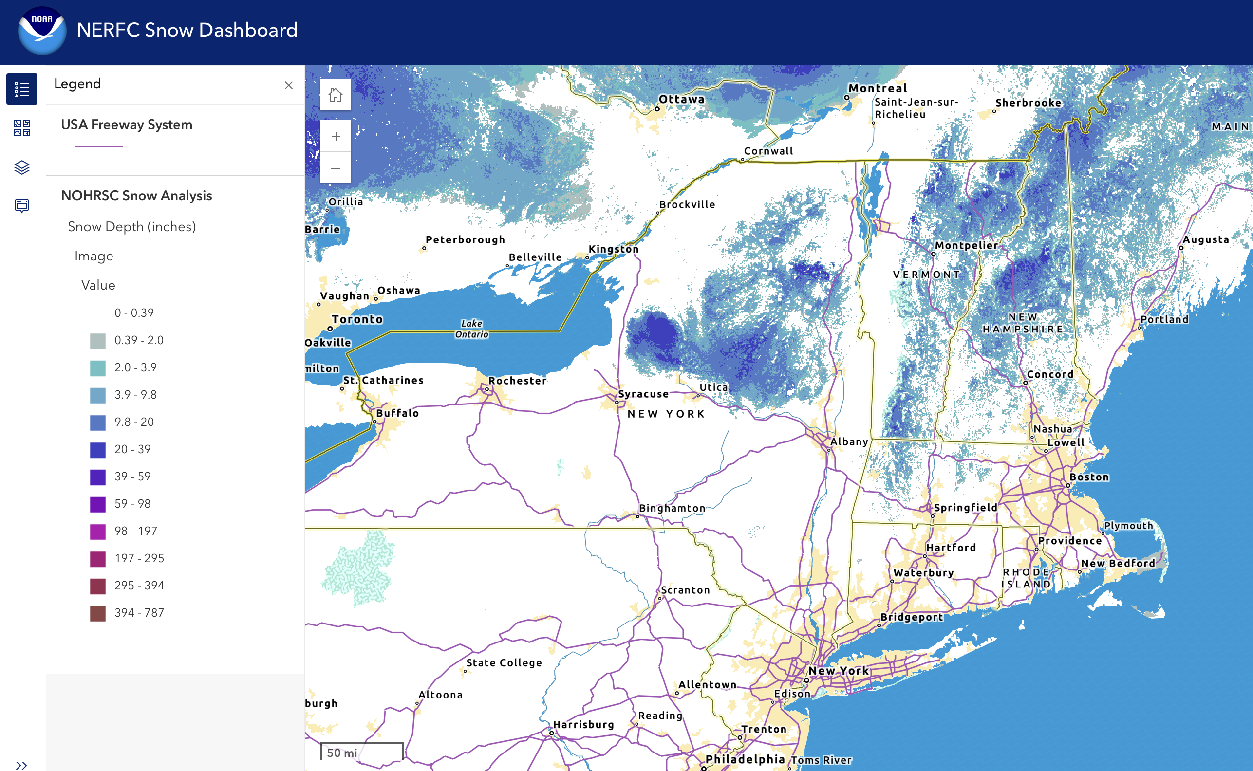
Best skiing is in the northwestern part of the Northeast-US and as high as you can go: the Tug Hill or Adirondacks, central to northern Vermont, and the White Mountains.
This post is about conditions for Mar. 13, 2026, and forecast for the next few days. See jump links to Conditions and Forecast.
What will the skiing be like?
[Update Friday 3/13] Many spots are hoping for a refresh of several inches of snow late tonight before regrooming. Centers that have been open reported hard and fast conditions if they are in the far north or at high elevation, and soft/wet conditions otherwise. Some have adopted the term ‘adventure skiing’ to describe touring on trails that have undergone repeated melt and refreeze without grooming. State of the touring centers has been updated as of Friday.
Conditions recap: skiing this week could be had as close as western Massachusetts and southern Vermont, but the pickings have been slim and conditions marginal. Areas closed trails to preserve the base and are hoping to repair and groom for the weekend. Others have remained open but curtailed or halted groominmg. Conditions have been ‘wet granular’ for the most part, with soft and slushy snow – it’s been that warm. And that means it’s slow skiing.
Ungroomed conditions might have been similarly soft and slushy this week, but with greater chances of encounters with ice or crust unless the warmth and sun melted that off.
Over the next several days a series of temperature swings, combined with multiple systems bringing precipitation will create a lot of day-by-day variability in the surface snow conditions. In other words, pack Maxiglide and a scraper, and maybe a change of socks.
For waxable classic skis with snow at or a touch above freezing, it’s klister time.

Hit up ‘State of the touring centers‘ or in the menu above late Friday or early Saturday for reported conditions, because a number of places will wait until then to reevaluate their trail maintenance plan. The slide show below of snow depth visualization graphics for this past week shows the impact of our sudden spring on the snowpack:

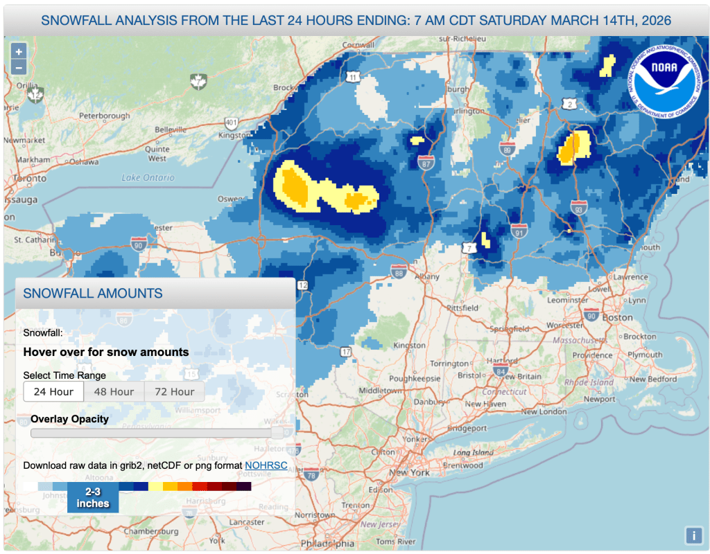
Saturday Mar. 14: a small but usefully-timed refersh of snow will help those trails that are still in reasonable shape:
Upcoming weather
Weather recap: we had some rain the far north on Wednesday, but not as much as the previous weekend. On Wednesday evening and Thursday morning rain came to the downstate and NYC metro region. Early spring warmth plus the rain did a lot of damage to the snowpack, with some ice jams and river or low-lying area flooding in the north early in the week.
Forecast summary: cooler end of week, then warmer on the weekend with snow expected Friday into Saturday in the far north and rain elsewhere/ Sunday will be very warm with rain or rain showers across the Northeast-US. Dramatic cooling late Monday to midwinter temperatures during the midweek.
Day-by-day forecast
Temperatures colder on Friday, with the coldest part in the northwestern parts of the Northest-US (upstate New York). Snow and snow showers begin from the west in the morning, followed by snow north of Albany and the VT-NH/MA border later in the day. By late afternoon or evening, downstate NY and southern New England will start getting rain. Snowfall could be impactful particularly in the Tug Hill and Adirondacks, where several inches could fall. There is also potential for a a few inches in th mountains fo northern Vermont and New Hampshire. Precipitation will leave overnight, with lingering snow showers in the far north on Saturday. Generally calm winds start getting disturbed with 35-45mph gusts late in the day Friday.
[Update Friday 3/13] Several inches accumulation predicted in northern-central NY, the Tug Hill and Adirondacks Friday into Saturday. Moderate accumulation of 5+ inches predicted for SW Adirondacks, eastern Catskills, and southern Greens/VT areas.
On Saturday a cool day overall with the warmer air in the southeast portion of the Northeast-US (NH lakes region). Some strong gusts in excess of 35-40mph at elevation in the mountains.
By Sunday warmth spreads more evenly across the Northeast-US. A front forms up with precipitation starting early in the morning as snow showers. This will transition to rain showers starting in the south later in the day, intensifying during the overnight period. Rainfall could be moderate to heavy in the southern parts of the Northeast-US and the eastern seaboard. [Update Friday 3/13] Strong winds expected Sunday night.

Rain continues on Monday, with daytime temperatures even warmer than Sunday. Rain expected to be heavy at times. However, if cold air arrives it may convert rain to wintry mix and snow showers, creating possible driving hazards Monday night. Southerly winds with some gusts of 25-35mph in the course of the day, and stronger gusts along the shoreline. There is still some uncertainty as to the combined impact of the arriving cold front from the west with a warmer mass of air toward the south/southeast.
[Update Friday 3/13] Rainfall of more than 1″ expected during the Sunday-Monday period, with greatest amounts toward the south.
Tuesday temperatures will drop dramatically as cold air arrives from the west, which unfortunately does not bring any precipitation, nor is it expected to meet a system in the Atlantic which could form a storm. Winds and gusts will be calmer than Monday.
Wednesday will see midwinter temperatures. Late Thursday into Friday could have a mix of rain and snow showers across the Northeast-US, with snow showers primarily at elevation in upstate/northern NY and northern New England.
Weather Prediction Center estimates the 6-10 day period is somewhat likely to be cooler than normal with precipitation near normal. 8-14 day period is likely to be cooler but drier than normal.
| Date / Daytime high temp | Mountains in northern NY, VT, and NH | Lowlands from central NY to NH interior | Hudson Highlands to NYC metro |
| Fr 3/13 | Teens to upper 20s | 30s | 40s |
| Sa 3/14 | Teens to upper 20s | Low 30s to low 40s | Upper 40s to low 50s |
| Su 3/15 | Low 20s to low 30s | Upper 30s to low 40s | Upper 40s to low 50s |
| Mo 3/16 | Upper 30s to upper 40s | Mid to upper 50s | Low 60s |
| Tu 3/17 | Teens to low 20s | Mid 20s to upper 30s | Upper 30s to low 40s |
| We 3.18 | Single digits to teens | Mid 20s to low 30s | Upper 30s to low 40s |
| Th 3.19 | Teens to upper 20s | Mid 30s to low 40s | Low to mid 40s |
