
Thanks to the groomers at Minnewaska State Park Preserve and the folks in the area, we’ve had groomed trails for seven weeks. Currently only the Upper Awosting trail is skiable, but it’s there for those who care.

It may feel like spring has truly sprung, but never say never in early March. If nothing else there’s still a decent snowpack up north. If it withstands the assault of the next few days we may still have some good skiing to come within a few hours of the downstate and coastal region.
This post is about conditions for Mar. 9 2026, and forecast for the next few days. See jump links to Conditions and Forecast.
What will the skiing be like?
Warm and wet spring skiing conditions through the middle of the week. Most grooming operations are halted for reevaluation Thursday or Friday. Colder temperatures arrive late in the week with multiple chances for snow that could revive conditions for the weekend.
It’s a bit difficult to know from the touring center reports and the weather whether any given set of trails will be wet and icy or wet and granular – one is pretty hard to ski, the other pretty nice. Both are slow.
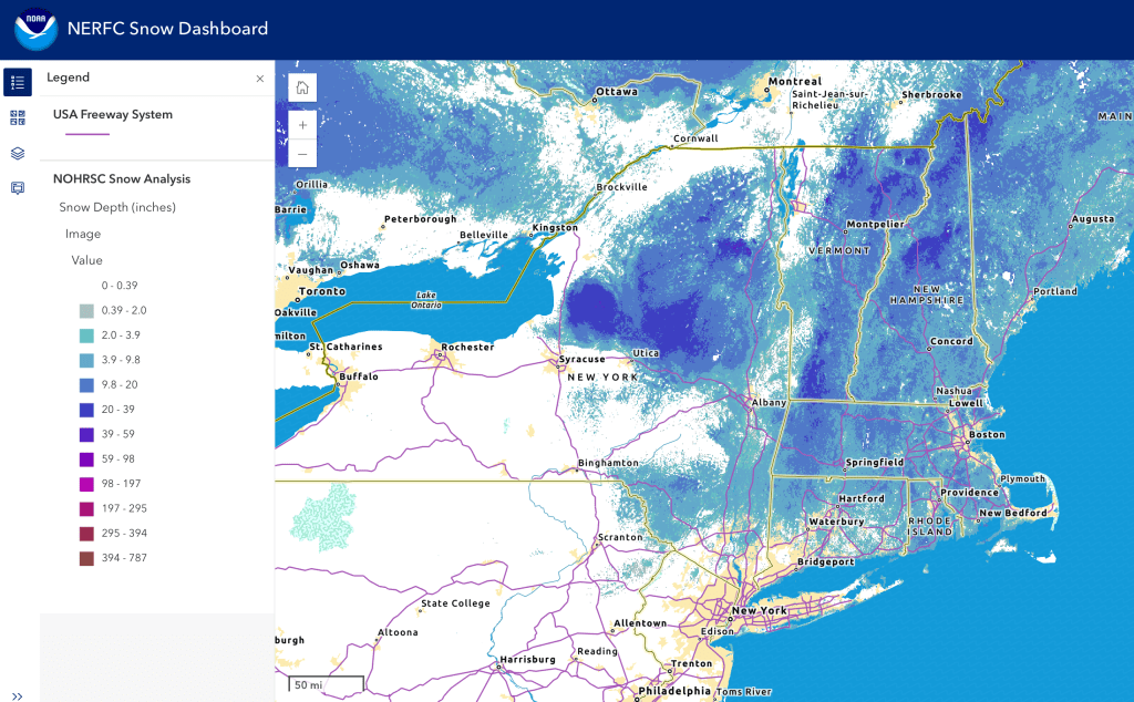
Hit up ‘State of the touring centers‘ or in the menu above for reported conditions as of today. Snow depth graphic below:
Upcoming weather
It’s a race between disappearing snowpack and relief from weather coming for the weekend. Multiple opportunities at the end of the week and over the weekend for light snowfall in the north. The day-by-day summary:
Light rain in the north Tuesday evening. Generally calm with mild breezes.
Rain showers intensify and overspread the northeast starting Wednesday morning, moving from west to east, and continuing through the day.. Rain could be heavy at times. Retained cold air in the north and west of the region could result in icing. River flodding is a possibility. Winds gusts get stronger in isolated areas at first and more widely later, peaking to 30+mph.
Precipitation fades to rain showers Thursday morning, and may convert to snow showers Thursday afternoon before ending. Freezing rain in the north is a possible hazard. Wind gusts become calmer, to 20mph or so.
Friday, wintry mix and snow showers sweep across northern New York, Vermont, and New Hampshire. Southern New England and downstate New York will get rain showers.
A repeat pattern of precipitation look to fall over the weekend – snow showers or wintry mix up north, rain or rain showers in the south. Wind gusts could reach 30mph. The end of the weekend into Monday may include somee rain or rain showers up north. Increased gustiness late Sunday into Monday, up to 35mph at elevation.
Weather Prediction Center estimates both the 6-10 and 8-14 day weather will likely be cooler and with more precipitation than normal for this time of year.
| Date / Daytime high temp | Mountains in northern NY, VT, and NH | Lowlands from central NY to NH interior | Hudson Highlands to NYC metro |
| Tu 3/10 | 40s | Upper 50s to upper 60s | Upper 60s to mid 70s |
| We 3/11 | Upper 30s to mid 40s | Upper 30s to mid 50s | Mid 60s to low 70s |
| Th 3/12 | Mid 20s to low 30s | Low 30s to low 50s | Mid 50s to low 60s |
| Fr 3/13 | Teens to mid 20s | Low 30s to low 40s | Mid 40s |
| Sa 3/14 | Teens to mid 20s | Low 30s to low 40s | Mid 40s to low 50s |
| Su 3/15 | Low 20s to low 30s | Upper 30s to mid 40s | Low to mid 50s |
| Mo 3/16 | Mid 20s to low 30s | Mid 30s to mid 40s | Upper 40s to low 50s |
