
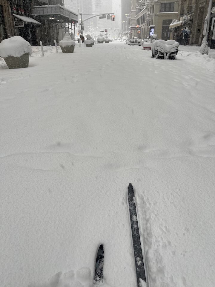
City folk sick of snow;
Celebration by XC skiers;
Can we commiserate over broken shovels?
19+” of snow recorded in Central Park, with higher amounts right at the coastlines. Unlike the other big snofall in January, this one delivered heavy wet snow, the kind that breaks backs and shovels. Given the amount of snow and the travel ban in effect, what better time for a ski along city streets?
A classic New England nor-easter… ‘Gorilla Glue; snow
Massachusetts state senator Julian Cyr
Where to ski? Anwwhere – but bring your maxiglide and a scraper just in case. Update on the local ski touring centers:
- High Point – open. Received 8-9″ of snow.
- Fahnestock Winter Park – closed today, will open Wednesday. Received 20+” of snow.
- Minnewaska State Park – open, Conditions very good. Received 7″ of snow.
- Mohonk Mountain House and Preserve trails – most groomed and tracked, in progress on golf course and Preserve.
How did such a large storm build so quickly? Read a story from the AP that has a pretty good summary. This post is about conditions for Feb. 24, 2026, and forecast for the next few days. See jump links to Conditions and Forecast.
What will the skiing be like?
BETA report of 2/21 tells of new fallen, heavier snow with additional snow due (Friday-Saturday 2/20-21) refreshing backcountry trails that were previously packed down.
The key for skiing this week is to note the north-south temperature and snow differential. With warm temps in the south, cold up north, dress and wax accordingly!
- Wednesday: Up north hard wax and good conditions, with temperatures from the 20s to 30s and a forecast for an inch or two of snow across the southern Adireondacks/southern Vermont, down to the Catskills and Berkshires. In the southern regions, above-freezing daytime temps across will make for softer, sloppier conditions, Expect to use waxles skis and have slower conditions by midday.
- Thursday-Friday: variably sunny skies with overnight snow showers will make for some really nice ski days.
- The weekend: temperature swings from Saturday to Sunday will make waxing tough – warm one day, cold the next. Pack the wax kit.
Hit up ‘State of the touring centers‘ or in the menu above for reported conditions as of today. 48hr snowfall prior to today and Snow depth graphic below:
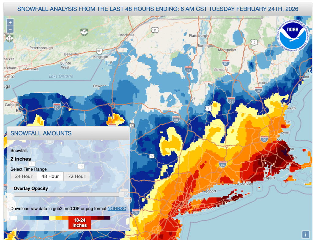
One of the top ten snowstorms for NYC, the accumulation broke records in Long Iland and Rhode Island. It was a coastal storm, as the total accumulations went down markedly within twenty miles or so of the coast, except for a branch that went up the Hudson to meander through Westcheter county and southwestern Connecticut.
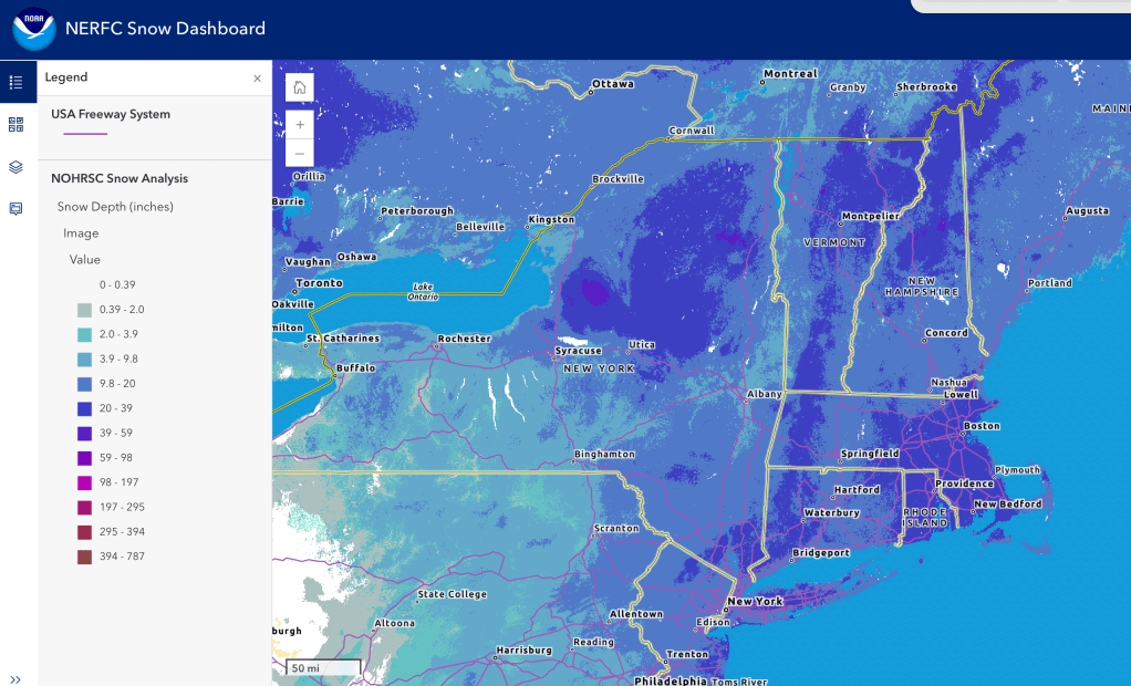
Between this storm and a light refresh of snow further north at the end of last week, the snowpack is looking very healthy for the moment. You can easily tell by the darker blue (indicating 20-39″ snow depth) where the mountains are!
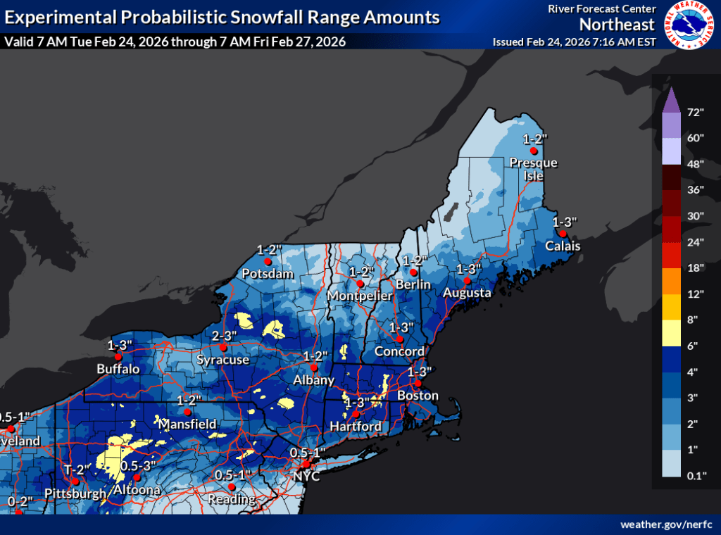
Upcoming weather
Rising temperature trend till Saturday, and a quick drop to wintry temps on Sunday. A couple of small systems Wednesday and Thursday, and an undetermined potential for another system for the beginning of next week. Here’s the day-by-day:
- A fast-moving clipper system brings light snowfall across the northeast in the early morning of Wednesday, moving from west to east. The system will drop a bit of snow and be over for th esouthern regions (southern NY and New England) by late afternoon, with lake effect snow continuing up north that will result in additional accumulation. Mostly cloudy skies. Breezy with isolated areas having wind gusts of 30mph.
- Thursday will start dry, but a small system will bring precipitation for the southern regions moving southwest to northeast. The system will move out by Friday morning. Partly cloudy and also breezy, with gusts up to 20mph.
- Friday and Saturday will be dry, and mostly sunny, with calm winds Friday, with isolated gusts in the far north on Saturday. Gusts could be 35+mph.
- Temperatures will drop sharply on Sunday. Partly cloudy to mostly cloudy. Variable breeziness across the northeast, with gusts of 20mph.
- Starting in the overnight from Sunday to Monday, there is potential for another system that may bring light snow showers to the northeast. As yet the NWS forecast discussions do not mention anything definite.
Night time temperatures up north will be cold enough to keep the snow for a while and let it transform nicely. Further south, and particularly in the downstate NYC area, the daytime temps through the end of the week and some fairly sunny days could result in developing dense, icy snowpack unless groomed regularly.
| Date / Daytime high temp | Mountains in northern NY, VT, and NH | Lowlands from central NY to NH interior | Hudson Highlands to NYC metro |
| We 2/25 | Teens to low 20s | Low to mid 30s | Upper 30s to low 40s |
| Th 2/26 | Teens to low 20s | Mid 20s to mid 30s | Upper 30s |
| Fr 2/27 | Teens to low 20s | 30s | Upper 30s |
| Sa 2/28 | Mid 20s to mid 30s | Upper 30s to mid 40s | 40s |
| Su 3/1 | Teens | Teens to upper 20s | Upper 30s to low 40s |
| Mo 3/2 | Below zero to single digits | Teens to low 20s | Upper 20s to low 30s |
| Tu 3/3 | Teens | Upper 20s to low 30s | Low to mid 30s |
