

[Update Sunday morning 2/22] Timing of the storm is now a bit slower, with the track shifting slightly westward, resulting in increased impacts for New Jersey and the NYC metro area as well as the lower Hudson valley, and a slight delay in heaviest snowfall for NYC area. NYC area forecast discussion is now calling for heaviest snowfall staring late tonight, and saying there’s a very small (10%) chance the NYC metro could get clsoe to three feet of snow, due to changes in the snowfall:liquid equivalent ratio. Have not updated graphics, but the ‘red areas’ have expanded to encompass the lower Hudson valley and across most of northern New Jersey.
[Update Saturday afternoon 2/21] Snowfall amounts and spread have increased, and timing of most intense snowfall moved slightly later on Sunday. See below for details.
Blizzard warnings issued for New York City and coastal region including Long Island, as a major storm is now predicted to impact the region Sunday evning through Monday morning. Warnings or Watches issued from DelMarVA through Boston.
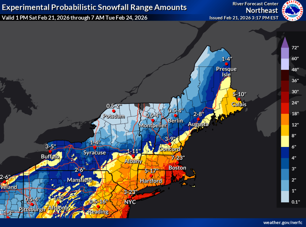
What about the rest of the northeast? Hit the jump link to Refreshed Recration or scroll to the bottom. Forecast for southern New York and coastal New England continues below, starting with estimated snowfall graphic:
Along the mid-Atlantic coast including NYC, Sunday may start with the unholy trinity of snow, rain, and wintry mix. this will gradually shift over to all snow by the late afternoon. The NYC metro area is expected to get a few inches of snow Sunday evening, with the bulk of snowfall happening during the overnight period. Snow continues into Monday morning before tapering off. Totals could be quite massive along the New Jersey coast and parts of Long Island. New York City itself could get as much as a foot of snow. Totals will fall off sharply inland, but Fahnestock and High Point could get 10+”, and Minnewaska/Mohonk could get several inches.
Winds build during the late afternoon Sunday, with the highest winds south and on the coast. Winds could exceed 20mph Sunday night with gusts of 30-40mph. Along the coastal area, winds and wind gusts could be over 50mph. North and inland of the area affected by the storm, wind conditions will be much milder, with gusts of 20mph or so. Strong winds and severe wind gusts will persist in the downtate and coastal areas through Monday before tapering off Tuesday and becoming calm by middle of the week.
Note that as recently as Thursday evening, the National Weather Service was on the fence about the track of the system in the Atlantic, and how close its approach to the coast would be. It’s a large system and it was always certain the NYC metro and southern coastal New England areas would get a lot of precipitation. Barely 24 hours out, language in forecast discussions still seem to have slight doubt as to the amount of actual snow. This is IMHO, but I sense ‘an abundance of caution’ in declaring these winter weather advisories. We’ll find out in another 36 hours.
Given the huge population that will be affected, below is a slideshow gallery of graphics from each regional office from Philadelphia to Boston, and Albany to the north, showing a more detailed mapping of forecasted snow through Tuesday 2/24 (updated Saturday afternoon 2/21.
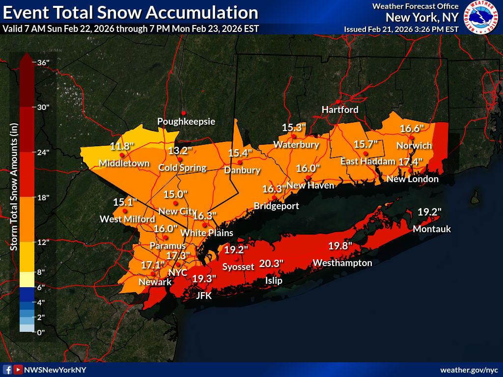
Forecast snowfall for NYC metro, Feb. 21 thru 24 2026 (NWS NYC) 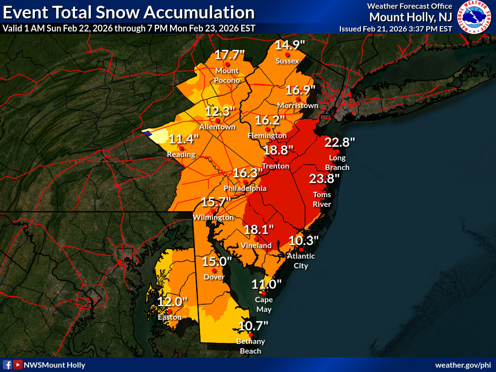
Forecast snowfall for Philadelphia & NJ, Feb. 21 thru 24 2026 (NWS Philadelphia) 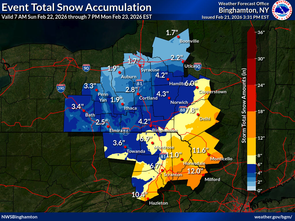
Forecast snowfall for southern New England Feb. 21 thru 24 2026 (NWS Boston) 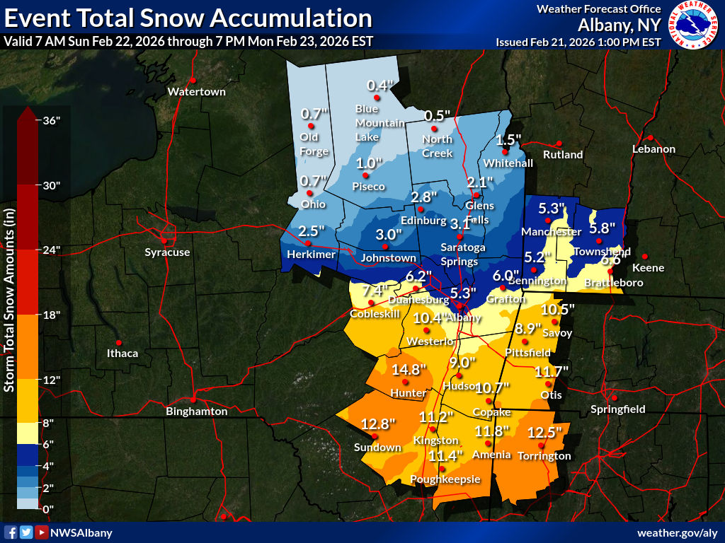
Forecast snowfall for Catskills & mid-Hudson, Feb. 21 thru 24 2026 (NWS Albany) 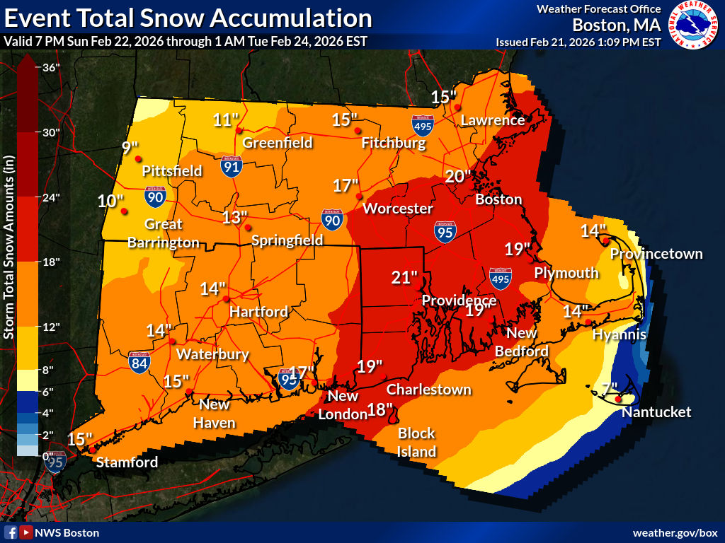
Forecast snowfall for south-central NY Feb. 21 thru 24 2026 (NWS Binghamton)
If the snowstorm happens as predicted, it amounts to a needed refresh of snow for the southern areas of this corner of the US. The skiers of the downstate woods If be cheered, as we could get a sixth week of groomed trails in our area, while at the same time less than happy about shoveling out the driveway, walk, and cars. Unlike the last big snowstorm however, we won’t have days of sub-freezing temperatures, so this snow is going to melt off much faster.
[Update Saturday afternoon] Snowfall totals for NYC are now expeted to be 12-18″, and the New Jersey shore could get 2 feet of snow. Area of snow accumulation has widened, so local ski touring areas could get a foot of snow. Boston and southeast Massachusetts may get 2 feet of snow. All forecast graphics have been updated.
Ground surface temperatures will start out just about freezing on Sunday, and will be well below freezing following Sunday, Monday, and Tuesday nights. We will probably have California wet snow becoming frozen overnight for the first part of the week. Higher daytime temps will degrade the snowpack into sloppy spring condition downstates later in the week.
| Date / Daytime high temp | Mountains in northern NY, VT, and NH | Northern lowlands | Hudson Highlands to NYC metro |
| Su 2/22 | Teens to mid 20s | 30s | 30s |
| Mo 2/23 | Single digits to teens | Mid 20s to low 30s | 30s |
| Tu 2/24 | Single digits | Mid teens to mid 20s | Upper 20s to low 30s |
| We 2/25 | Teens to low 20s | Upper 20s to mid 30s | Mid to upper 30s |
| Th 2/26 | 20s | Low 30s to low 40s | Mid 40s |
| Fr 2/27 | Teens to mid 20s | 30s | Low 40s |
(temps expressed in ˚F)
Meanwhile, in other news: refreshed recreation up north
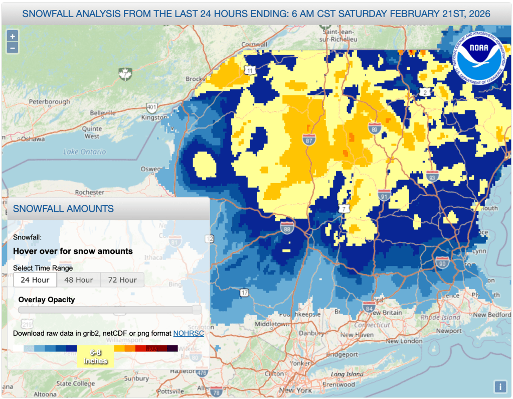
The northern part of New York and New England got a handy refresh of snow in the last 24 hours. Several inches of snow from the northern Berkshires and Albany/Schenectady northward, with greater accumulations in the mountains. See graphic below:
All in all, looks like a good week to be a gig worker or retired.

