
There will probably be some NYC local touring centers open through the weekend, which will make it five weeks that we’ve had groomed trails inm day-trip distance. But there’s been one casualty- rain yeterday caused High Point has to close for now and hope for snow. Will we get a needed refresh this weekend? See the forecast below for more.
Meanwhile, Fahnestock is open for Friday but sounding iffy about the weekend; Minnewaska trails are in ‘fair to good’ condition; and Mohonk has all trails open but groomed around the mountain house only for today.
This post is about conditions for Feb. 19, 2026, and forecast for the next few days. See jump links to Conditions and Forecast.
What will the skiing be like?
Spring skiing conditions, somewhat sloppier further south. In the northeren areas and at elevation, trails will be frozen granular in the morning and pretty slick, softening by late morning. Further south and especially in open areas, trails will have some icy and wet spots.
Still pretty good conditions for skiing, although it’s time for klister for sure

After Saturday conditions south of the High Peaks, northern Green Mountains, and White mountains will be whatever Mother Nature leaves for us. Think of a trip north for this weekend, but be prepared for a messy drive back or stay on through Monday.
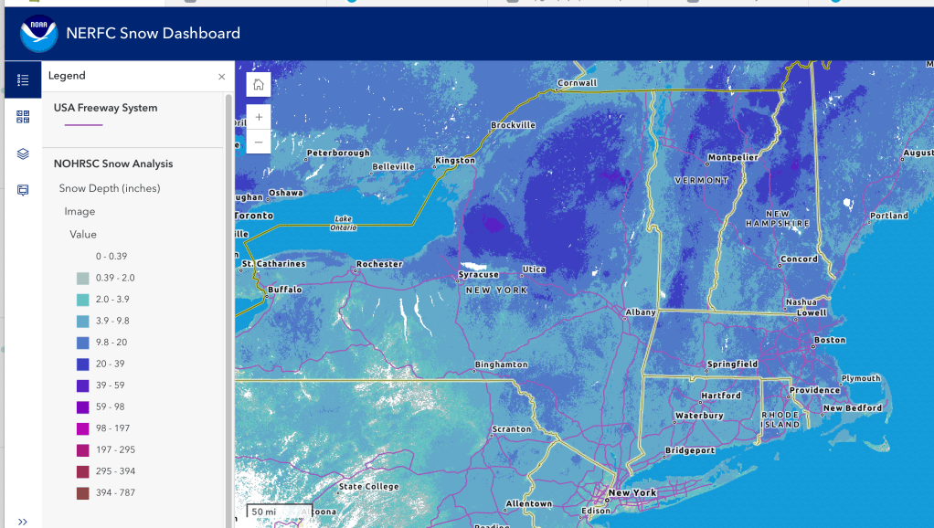
Hit up ‘State of the touring centers‘ or in the menu above for reported conditions as of today. Snow depth graphic below, showing a distinctly thinner snowpack.
Upcoming weather
Highlights:
- Possible driving hazards from the Hudson Highlands to the southern Adirondacks and southern Vermont in the form of freezing rain and ice Friday and Saturday.
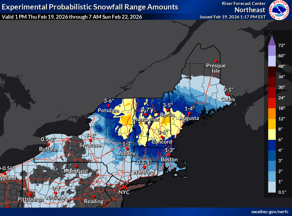
- Likely 6-8″ of snow in the northern areas by Sunday morning, but the Hudson valley and coastal regions will get rain this weekend
- Another system follows immediately on Sunday, with some possible snow and wintry mix for southern NY state and New England.
- A third system will arrive next week during the midweek. Impact is uncertain, but with warmer temperatures, much of the northeast will get rain showers on Wednesday the 25th and Thursday the 26th.
Details
Precipitation begins early morning Friday starting from the south. Rain along the coast and NYC, wintry mix just inland, and ice, wintry mix, and snow across the Cateskills, mid-Hudson and interior of southern New England. During the day, rain will spread as far north as Albany and the I-90 corridor. Just north of that a sizable zone of rain/ice could extend up into the southern Adirondacks and Vermont. Beyond all that, the far north will see areas of wintry mix and light snow that will become a steadier snowfall during the afternoon and evening.
Snow continues and overspreads much of the region overnight into Saturday morning. Areas from the mid-Hudson south and southern New England will continue to receive rain and wintry mix at best however. Light snow showers will continue intermittently across the northeast through much of the day Saturday into the night, with good chances for 6-8″ of snow falling in the Adirondacks and Vermont. Unfortunately the Hudson valley and NYC area will still get rain.
Sunday’s weather will come from a different front that will continue bringing precipitation starting from the south and west. Depending on the track of the low in the Atlantic, there could be rain/snow or a complete miss. Impact if any will be south of the High Peaks and Northeast Kingdom of Vermont. Light snow showers from this system will continue through Sunday and most of Monday. Wind gusts of 20-25mph or so confined to the coast will occur more generally across the region in the start of the week.
Tuesday will be dry with less gusty winds. Skies will be partly sunny.
There is no mention of a midweek storm in NWS forecast discussions. The following is based on my review of the website visualization of the NWS digital forecast.
- Wednesday a system brings snow showers to the northeast generally, beginning in the early morning from the west. As wilth the weekend’s system, the Hudson valley and coastal areas will be getting wintry mix or rain. Wind gusts increase again to 20-25mph.
- Snow showers continue to Thursday, but warming temps will enlarge the zone of rain/mixed precipitation to encompass all of southern New England and NY State up to the Catskills and southern Adirondacks. The Hudson and Connecticut river valleys will channel that warmth even further up north.
| Date / Daytime high temp | Mountains in northern NY, VT, and NH | Northern lowlands | Hudson Highlands to NYC metro |
| Fr 2/20 | Low to mid 20s | 30s | Low 30s to low 40s |
| Sa 2/21 | Teens to low 20s | Mid 20s to low 30s | Mid 30s to low 40s |
| Su 2/22 | Teens to mid 20s | 30s | 30s |
| Mo 2/23 | Teens to low 20s | Upper 20s to low 30s | 30s |
| Tu 2/24 | Teens | Low 20s to low 30s | Mid to upper 30s |
| We 2/25 | Teens | Upper 20s to low 30s | Low 30s to low 40s |
| Th 2/26 | 20s | Low 30s to low 40s | 40s |
