
We missed out yesterday on a timely refresh for the mid-Hudson. Nevertheless, we’ve now had four weeks to enjoy groomed XC trails in the NYC day-trip zone! Fahnestock is open, High Point still skiable, Minnewaska has groomed all trails and reports conditions as ‘very good’, and Mohonk has groomed most trails this morning.
This post is about conditions for Feb. 17, 2026, and forecast for the next few days. Will we see a fifth consecutive week of groomed trails at our parks, hopefully convincing bosses and bean-counters that XC skiing isn’t dead yet. Read on for more, or just hit the jump links to Conditions and Forecast.
Happy New Year
Tomorrow marks the start of the ‘year of the Fire Horse ‘(火馬年). FYI, the Olympic silver medalist Ben Ogden turned 26 a few days ago, making him a Metal Dragon (庚子龍). A fitting sign, for it combines ‘the Dragon’s ragon’s sky-high ambition with the Metal element’s earthly strength’. He may not have been born in the year of the horse, but he sure was on fire last Tuesday.
Ogden’s backflip off the podium went kind of viral, and was a bit more wonderful because of what happened immediately before and after. It began with Johannes Høsflot Klæbo’s puzzled expression when Ogden handed him his medal to hold, and then paid off when Klæbo let his reserve crack by following Ben’s lead, rotating in the air while jumping off the podium. Klæbo is a cross-country ski competitor like no other, but this was the kind of thing Americans do better than anyone – put work and play together. It’s an underrated connection that’s at the heart of creative energy.
What will the skiing be like?
Spring conditions with mild or warm temps for the next few days, and for the start of the week partly or mostly sunny skies. The past few days and up through tomorrow or Wednesday could be among the nicest days to ski this season. BETA report of 2/14 reports the good conditions continue, with additional snow to come Tuesday.
Expect trails to be a bit frozen in the morning and fast, softening up by late morning and becoming becoming very soft and even wet in the afternoon. Waxing is going to be klister most likely unless new snow is on top, in which case it might be some softer type of hard wax. Going waxless is probably a good idea, or skate skiing.
Hit up ‘State of the touring centers‘ or in the menu above for reported conditions as of today. Snow depth graphic below:
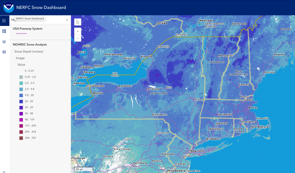
The cover is starting to get a bit thin in the valleys and downstate region, although things are still decent at elevation. Given the forecast, best to think about heading north to ski by the weekend.
Upcoming weather
Summary:
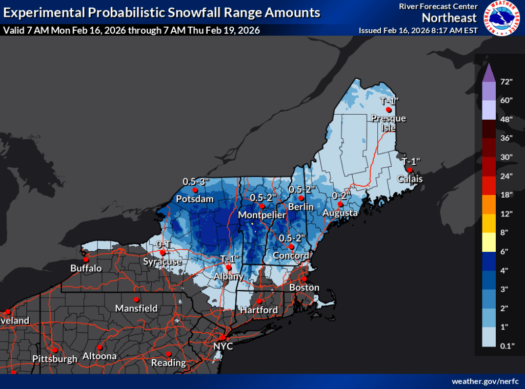
There’s two or three opportunities for some snowfall during the upcoming week, with potentially the largest but least certain storm during the weekend. The warm temps mean greater chances of rain or wintry mix especially for the valleys and southgern regions, which puts the snowpack in the NYC metro area at risk. By the end of the week however, temperatures will be on a slight cooling trend, and for the 6-10 day outlook, the WPC estimation is temps will be near normal for this time of year.
Steady temperatures through the week, with daytime temps above freezing across the northeast, and night time lows flirting with or slightly above freezing in the downstate region. Placid winds until Friday, when gusts of 15-20mph in parts will come in for the weekend, coinciding with a change in weather.
By the bullets:
- Light snow and wintry mix in the early morning hours of Tuesday, lingering in the far north till the afternoon.
- Precipitation arriving Wednesday morning starting from the west, continuing into Wednesday night. Rain for the area south of Albany or possibly the southern Adirondacks, and southern New England. Wintry mix could fall as far north as the High Peaks, central Vermont and New Hampshire. Storm will taper off Thursday daytime. Accumulations could be 2-4″ north of I-90, barely a dusting if any downstate.
- Early Friday a second round of precipitation will arrive, starting from southwest. This will bring light rain, wintry mix, and snow showers to the entire region and continues through Sunday. Rain showers and wintry mix will primarily be in Connecticut and the downstate NY area. Exact mix of precip types and location will depend on how much temperatures follow a downard trend during the weekend. Forecasting of amount and type uncertain at this time.
- By Monday temperatures will be cooler, with the coldest daytime temps toward central and upstate New York, and northernmost New England.
| Date / Daytime high temp | Mountains in northern NY, VT, and NH | Northern lowlands | Hudson Highlands to NYC metro |
| Tu 2/17 | Upper 20s | Mid 30s to low 40s | 40s |
| We 2/18 | Upper teens to mid 20s | 30s | Upper 30s to low 40s |
| Th 2/19 | Teens to low 20s | 30s | Upper 30s to low 40s |
| Fr 2/20 | Teens to low 20s | 30s | Upper 30s to low 40s |
| Sa 2/21 | Teens to low 20s | 30s | Upper 30s to low 40s |
| Su 2/22 | Teens to low 30s | Upper 20s to mid 30s | Upper 30s to low 40s |
| Mo 2/23 | Teens | Low 20s to low 30s | Mid to upper 30s |
