
What can you say when the skiing everywhere is good? Go anywhere!
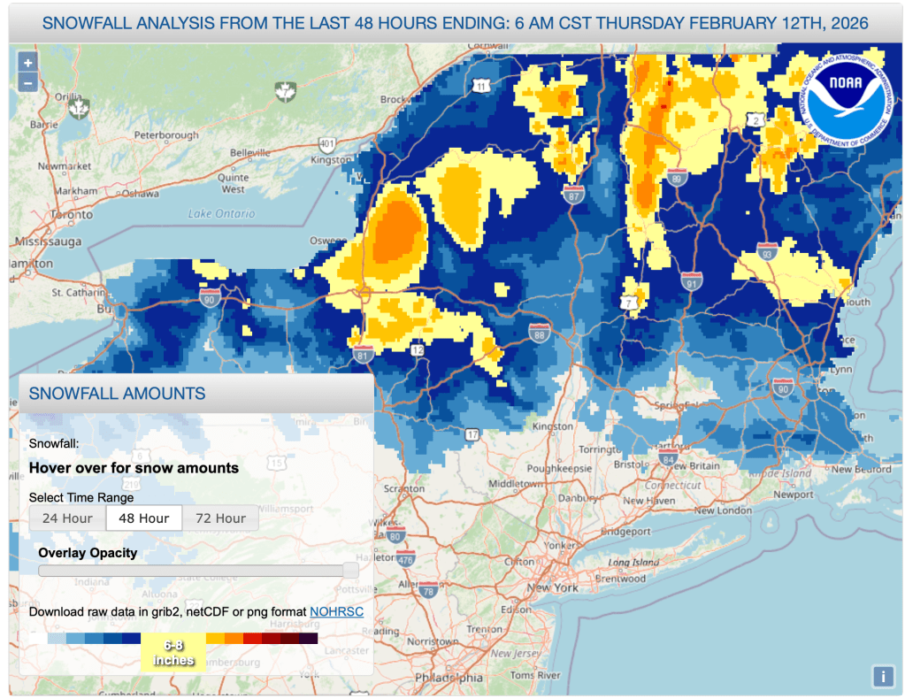
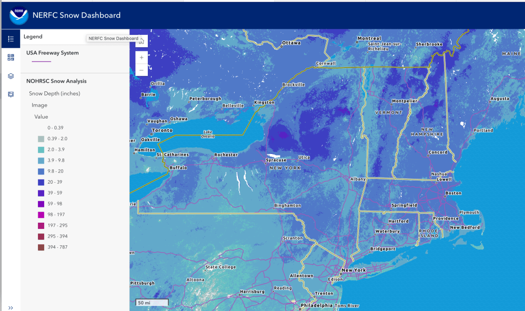
The trails with set tracks will be the best bet for anyone looking for skiing close to the NYC metro. Any snow that hasn’t been groomed or Ginzu’d is rock-hard by now. By the time you get to Albany and northward, anywhere from a dusting to over a foot of snow fell over the last two days. With mild weather the weekend is looking very good indeed.
This post is about conditions for Feb. 12, 2026, and forecast for the next few days. See jump links to Conditions and Forecast.
What will the skiing be like?
A good deal more snow fell during the midweek up north than anticipated. With fresh powder on top of a good base, anywhere north is looking pretty good, including any backcountry trails that have been skied out already. The downstate NY region holds firm with the existing snowpack. This is a brief summary, but what more can be said, except: ‘And the skis go on’, possibly through next weekend.
Hit up ‘State of the touring centers‘ or in the menu above for reported conditions as of today. Snow depth and snowfall for last 48 hours below:
Upcoming weather
Warm spell continues through the weekend, with temps slightly above ‘normal’. Multiple systems sweep through the region over the next week, the most consequential arriving lat Tuesday, bringing rain and rain showers to most of the northeast. Winds mostly calm with some moderate gusts of 15-20mph for certain days.
Highlights:
- Friday evening, light snow across northern New York and western and southern New England, ending early Saturday morning. Accumulation will be minimal. Isolated wind gusts of 20+ mph in som parts of southern New England Saturday afernoon.
- Sunday evening more light snow showers starting in the south and moving northeast. NYC metro and downstate region will get a wintry mix, but the interior and mid-Hudson region could get snow.
- Snow showers end by Monday afternoon or evening. Skies remain mostly cloudy Monday, with some variable clearning Tuesday afternoon.
- Tuesday overnight to Wednesday, a storm will begin to impact the northeast, starting as snow showers in the north and light rian the south. By Wednesday afternoon snow showers will be confined to the far north, and even parts of the Adirondacks, Green and White Mountains will get wintry mix or rain. South of Albany and the VT/NH southrn borders, the precipitation will be rain or rain showers only. Considerable uncertainty in track and interaction of systesfrom Canada and the Atlantic at that time Wind increase through Wednesday afternoon, with gusts of 20mph possible.
- The temperature gradient between the two systems arriving midweek will make for a 10+ degree difference in lowland daytime temps in the southern and easten areas compared to north and west.
The better news in terms of skiing weather is that the Weather Prediction Center (WPC) estimates a decent likelohod the one month average temps will be below normal, while preciptiation will likely be normal. But whether it will be rain or snow, nobody yet knows.
| Date / Daytime high temp | Mountains in northern NY, VT, and NH | Northern lowlands | Hudson Highlands to NYC metro |
| Fr 2/13 | Teens | Mid 20s to low 30s | Mid 30s |
| Sa 2/14 | Teens to low 20s | Upper 20s to mid 30s | Upper 30s to low 40s |
| Su 2/15 | Teens to low 20s | Upper 20s to mid 30s | Mid 30s to low 40s |
| Mo 2/16 | Upper 20s | Mid to upper 30s | Low 40s |
| Tu 2/17 | 20s | Upper 30s to low 40s | Mid 40s |
| We 2/18 | 20s | Upper 30s to low 40s | Mid 40s |
| Th 2/19 | 20s | Low 30s to low 40s | 40s |

