
Groomed ski touring trails near NYC have now been open for three full weeks. Will the base survive for another week? Will the lower Hudson get a bit of a refresh for a sweet Valentine’s Day? Read on for more.
All the local areas are open and have skiable conditions. Minnewaska reports very good to excellent on all trails except Smiley. Mohonk groomed a number of trails this morning. Fahnestock has groomed all trails and set tracks where appropriate. High Point is still skiable.
This post is about conditions for Feb. 9 2026, and forecast for the next few days. See jump links to Conditions and Forecast.
Side note: re-posting a link to my page on getting to ski areas without a car, which I updated after finding a short documentary about the Winter Park Express. It’s nice to know more about the old days the people who revived it.
What will the skiing be like?
Overall no major changes, as the cold weather kept the base and some light dustings of snow in northern NY and New England refershed the surface. Boston got a good dump, which should keep Weston’s golf course trails open and Great Brook trails happy.
With warming temps and a couple of sunny days this week, the existing snow will have transformed completely by the weekend. Expect fast skiing in the morning, and softer conditions in the afternoon. Some additional snow mixed in will hep with kick, assuming Mother Nature decides to deliver.
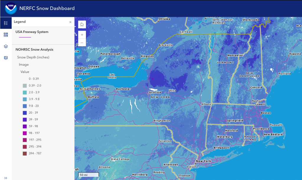
Hit up ‘State of the touring centers‘ or in the menu above for complete reported conditions later today. Snow depth graphic below:
Upcoming weather
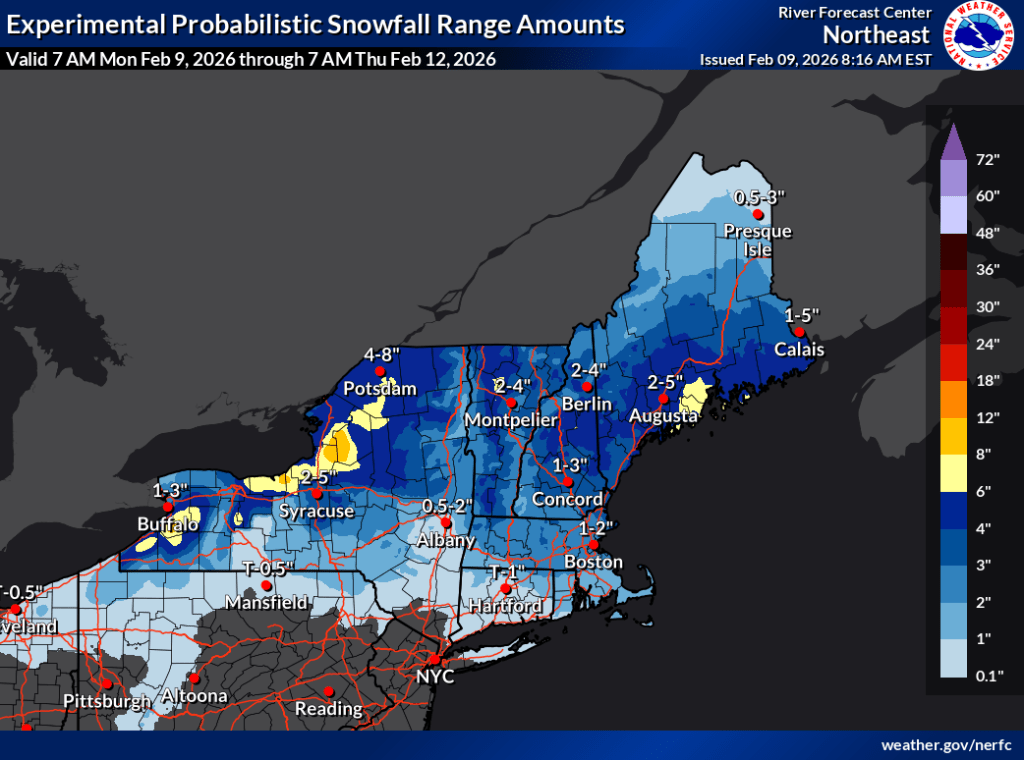
Summary: warming trend through the week. Light refresh of snow for northern areas midweek, and some additional snow Saturday evening into Sunday.
Highlights:
- Gusty winds continue on Monday in southern areas mainly, up to 25+mph. Mostly sunny.
- Light refresh of snow starting Tuesday morning in upstate NY and spreading eastward to northern New England, overspreading the northeast by Tuesday late afternoon. NYC metro and southern New England could see slight accumulation. The Tug Hill could get some wintry mix along with snow. Much calmer winds.
- Snowfall recedes south-north by Wednesday afternoon. Could get 4+” accumulation estimated in the far norrth, 2+” north of tthe I-90 corridor, little or no accumulation further south. Wind gusts pick up, with some 25mph gusts in isolated areas. Gradually clearing skies through Friday.
President’s Day weekend will start calm and sunny (good for being outdoors), but well above freezing for much of the region (bad for the snowpack). Precipitation begins Saturday evening starting in the south, overspreading the northeast by Sunday morning. Winds will remain calm for the first part of the weekend. As the precipitation moves northward NYC metro and coastal regions will likely see it shift to wintry mix or rain. Winds will also pick up somewhat as the system moves north, but nothing like this past weekend.
Weather nerd note:
If temperatures do not reach 32 earlier in the week, this thaw will end the longest deep freeze since the 2014-2015 winter. In Burlington, the last day with a temperature breaking 32 degrees was January 22nd; sub-freezing temperature streaks surpassing 21 days are fairly unusual in the Burlington area, last happening January- February 2015 and only occurring 20 times going back across the last 141 winter seasons.
Burlington VT NWS office, Feb. 9 2026
The National Weather Service Weather Prediction Center estimates over the next 6-10 and 8-14 day periods, weather in the northeast are likely to be warmer and wetter than normal.
| Date / Daytime high temp | Mountains in northern NY, VT, and NH | Northern lowlands | Hudson Highlands to NYC metro |
| Mo 2/9 | Single digits | Teens to low 20s | 20s |
| Tu 2/10 | Teens | Mid 20s to low 30s | Low to mid 30s |
| We. 2.1/11 | Teens | Mid 20s to mid 30s | Upper 30s |
| Th 2/12 | Single digits to teens | Low 20s to low 30s | Mid 30s |
| Fr 2/13 | Teens | Low 20s to low 30s | Low to mid 30s |
| Sa 2/14 | Teens | Upper 20s to mid 30s | Mid to upper 30s |
| Su 2/15 | Teens to low 20s | 30s | Mid 30s |
| Mo 2/16 | Teens to mid 20s | Mid to upper 30s | Upper 30s to low 40s |
