
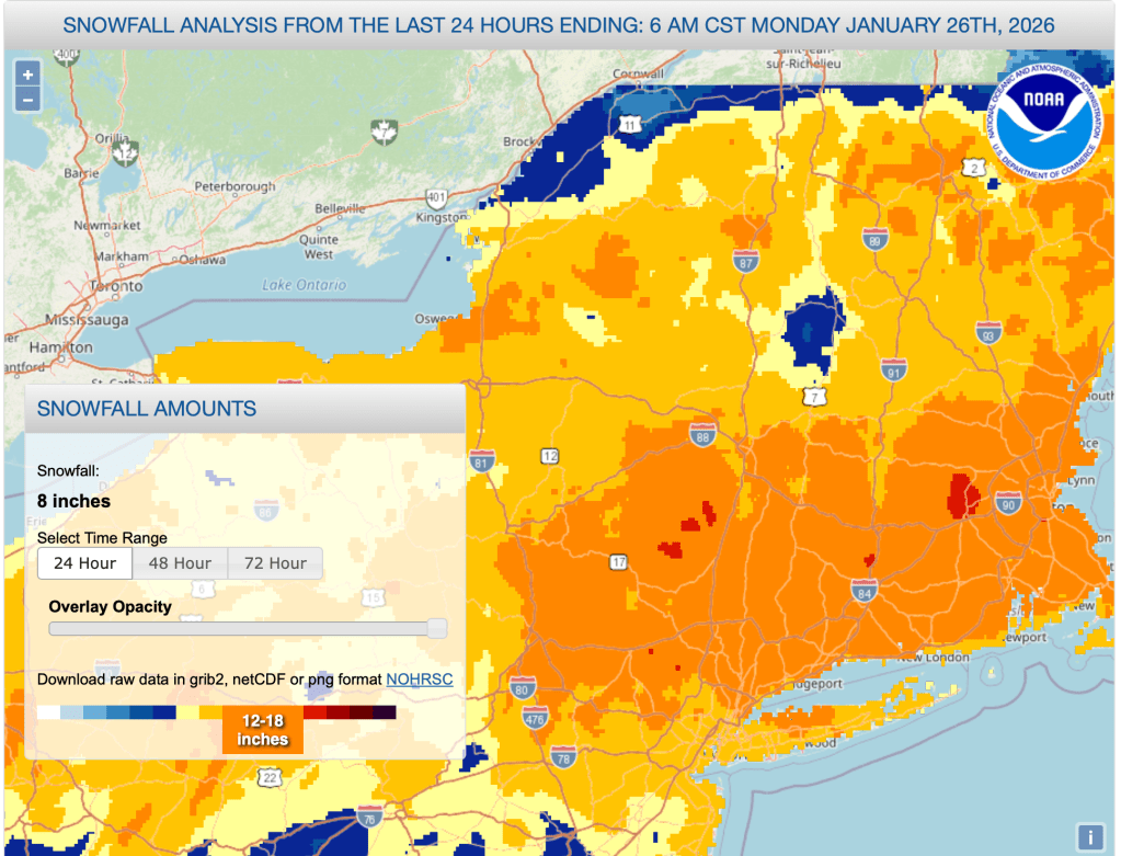
The NYT reported that as of this morning 11.8″ of snow had been recorded in Central Park. The NYC metro area is skiable terrain.

Now the digging out begins. It’s a great time for backyard skiing because the depth of snow makes it hard to plow through uness you have super-wide boards. Give it a day or two for snow to settle on trails, and for touring centers to clear parking lots, and pack and track.
This post is about conditions for Jan 26 2026, and forecast for the next few days. See jump links to Conditions and Forecast.
How’s the skiing in general?
There’s a bit of sleet and freezing rain mixed in with the fluffier snow along the coastal areas, but most of the region got all snow. Snow depth across the NYC metro and Hudson Valley region is 9.8-20″. Given the broad effect of the storm and amount of snow, I’d say trails up in the far north might be easier to ski but it’s way cold, while further south it’s a bit warmer but the roads and trails might be tough to get through for a day or so. Beware of wind gusts through Tuesday morning.
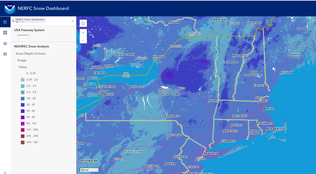
Once everyone digs out and the snow has settled or been rolled, skiing will truly be As.Good.As.It.Gets. What more can you ask for when over 90% of New York and New England get at least 8″ of snow? I’m holding off updating ‘State of the touring centers‘ to give parks and people a chance to assess and update. 24hr snowfall and snow depth graphics below:
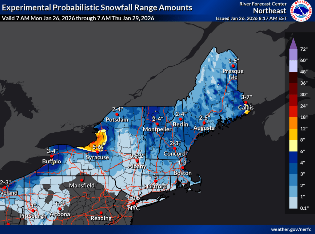
Forecast
You probably already know that the midwinter conditions are staying with us through this week and into next – Yay! There will also be some light refreshes of snow in far northern Vermont, New York, and some lake effect snow in the Tug Hill during the week. Some NWS stations are monitoring for a possible coastal storm for next weekend, but there is no certainty a storm will develop or impact the region.
The main issue for skiers will be wind at the beginning and end of the workweek. Given the tem,perature forecasts for Tuesday nad Friday, any wind will feel pretty brutal.
- oday through Tuesday midday, we’ll see gusts of 25-35mph for southern NY, and New England, as well as higher elevations before calming down for the midweek.
- Starting Thursday afternoon and into Friday, wind gusts anticipated to kick up again to 25mph or so in elevated areas of the southern parts of NY and New England like the Catskills and Berkshires.
- Calmer winds on Saturday and Sunday, except possibly northern New Jersey and NYC, which could get gusts of 35mph, especially right along the coast.
| Date | Northern NY VT NH mtns | Northern lowlands | Hudson Highlands to NYC metro |
| Mo 1/26 | Single digits | Teens to low 20s | Mid 20s to low 30s |
| Tu 1/27 | Below zero to Single digits | Teens | Teens to low 20s |
| We 1/28 | Below zero to Single digits | Teens to low 20s | Low 20s |
| Th 1/29 | Below zero | Single digits to teens | Teens to low 20s |
| Fr 1/30 | Below zero to Single digits | Single digits to teens | Teens |
| Sa 1/31 | Single digits | Teens to low 20s | 20s |
| Su 2/1 | Single digits to teens | Teens to mid 20s | Mid to upper 20s |
Stay warm out there!
The 6-10 day and 8-14 day estimates for temperature and precipitation from the Weather Prediction Center lean toward below normal for both (ie, likely below normal temperature, and leaning below normal precipitation for the period). So the ample snow we have will be around for several days. What more is there to say, but;

