
[Updated afternoon of Saturday Jan. 23] Big storm with lots of snow coming for much of the northeast! Some sleet or freezing rain possible for NYC and LI Sunday afternoon. See Forecast for the latest.
First the good news: All the groomed trails closest to NYC are still open, and conditions are commparable to the weekend, thanks to the weather. So take your pick: Fahnestock, High Point, Minnewaska, or Mohonk. Have your fun today or tomorrow if possible, because it will be much colder on Saturday.
The better news: A major storm could make NYC itself skiable terrain by Sunday evening. This post is about conditions for Jan. 22 2026, and forecast for the next few days. Want to know more? See jump links to Conditions and Forecast.
The immediate future is in Mother Nature’s hands. Or maybe Elsa’s from ‘Frozen’. Stay tuned for updates.

How’s the skiing in general?
Small, regular refreshes of snow have been taking place across the Tug Hill and northernmost areas of New York, Vermont, and New Hampshire. Combined with the colder weather, touring centers have put comments like ‘as good as it gets’, and ‘midwinter conditions’ into their reports.
Conditions are also better than expected for the Berkshires and mid-Hudson region compared to a week ago. It’s been a bit hit-or miss for a portion of Vermont in the upper Connecticut Valley. such as Hanover, Woodstock, and Brattleboro. But even so there’s been enough snow to groom something skiable.
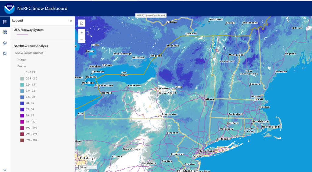
Except for whatever is lost due to today’s warmth, the base will remain intact, and areas that have snowmaking can run the guns at night. Hit up ‘State of the touring centers‘ or in the menu above for reported conditions as of today. Snow depth graphic below. And there’s more to come – see Forecast.
Forecast
[Update afternppm of Saturday Jan. 24 2026] Snowfall accumulation in the Catskills, Berkshires, and southern Greens could reach 18+ inches, and NWS Albany is saying this will be the biggest storm for that area since March 13-14 2023 (10.1″)
and possibly the biggest since December 16-17 2020 (22.9″). NYC and LI expecting 9-11 inches with some sleet mixed in. Accumulations higher inland. Although most of the snow will be very light and fluffy due to cold air mass in place now, a period of sleet or freezing rain could take place Sunday afternoon or evening as far north as I-84, if the ‘warm nose’ of the moist air system in the Atlantic pushes far enough inland.
[Update morning of Friday Jan. 23] Forecast trends continue to support an extended winter storm from Sunday into Monday, with warning-level (7″ or more) snowfall for NYC and the coastal areas, and conceivably more than a foot of snow in the mid-Hudson and the western portion of southern New England. The heaviest accumulation for the NYC and Hudson region will take place from early morning Sunday to mid-day. Alterations of the storm track at the last minute could bring some sleet or freezing rain to the coast late Sunday. Drivers should take all precautions, and homeowners should get those shovels ready at hand.
Downstate and NYC XC skiers might be able to take their skis to Prospect, Central, or van Cortlandt park by late Sunday afternoon. Fahnestock and the Hudson Highlands should get a good dump, and probably High Point as well. The Catskills, Berkshires, and even southern Vermont should get a very useful refresh of snow. But no rush – cold temps will keep that snow around. Temps in the souuthern areas will also be more comfortable than those in the far north next week, so get ready enjoy midwinter skiing conditions close at hand.
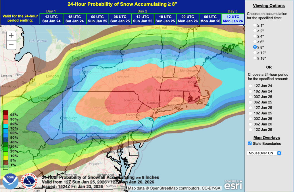
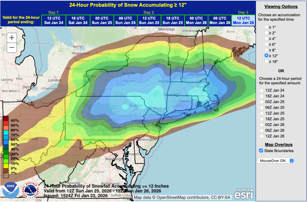
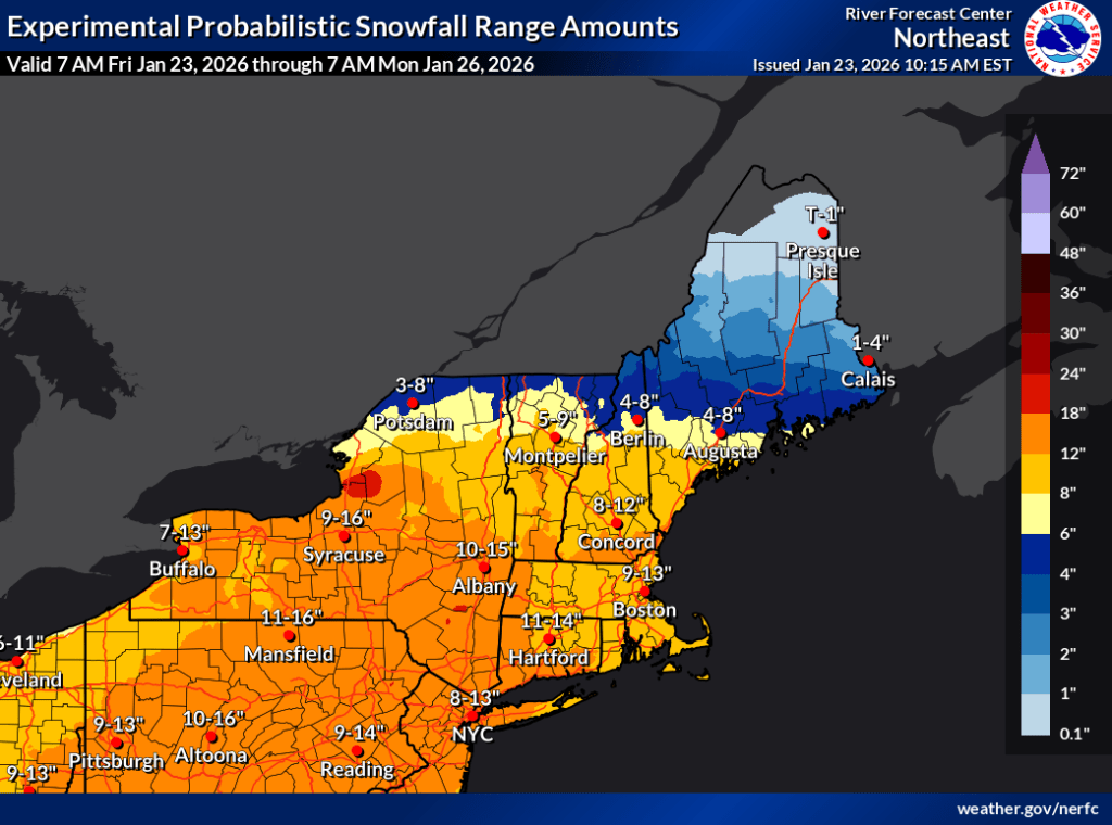
For prediction tracking purposes I’ve uploaded three graphics as of Friday Jan. 23, all from the NOAA:
- Weather Prediction Center’s probability for more than 8″ of snow by 7am Monday;
- Weather Prediction Center’s probability for more than 12″ of snow by 7am Monday;
- Northeast River Forecast Center prediction of snowfall range by that same date/time.
Of the two, I prefer the WPC because it’s a because setting soft boundaries like ‘we have an 80% chance of more than 8″ of snow, but barely a 50% chance of more than 12″ of snow’ leaves open the 20% chance we’ll get less than 8″. Maybe by tomorrow it will firm up, but for now that’s an important qualifier.
By now everyone knows a major winter storm is due to bring snow and ice to southern states and the midwest, before coming up the coast to the northeast. I can feel thousands of people refreshing the same web apps on the NOAA website that I’m using, because I’m getting occasional ‘504 Gateway time out’ errors, a sign of overload on the tech infrastructure.
Today and Friday:
- Warm Thursday, so enjoy the balmy weather. Ideal for skiing!
- Friday in the 30s downstate and cold up north. Winds will grow gustier, with peaks of 30-35mph in spots,
Saturday-Sunday:
- Frigid and freezing on Saturday. but winds should calm a bit compared to Friday but still gusting to 20+mph. Get the buff and lobster mitts.
- The storm is due to impact the northeast starting late Saturday, and snow will overspread almost all of the northeast by Sunday, with the haviest impact south of I-90. Winds will be much calmer t
han Saturday.until Sunday afternoon, when it will begin picking up in southern New England and along the mid-Atlantic and New Egnland coast - Forecasts over the last couple of days has trended toward: a) Increased chances of significant snowfall for eastern New York State and southern New England, and b) slowing of the coastal system as it comes up teh coast, resulting in higher snowfall totals. Although forecasters are hedging their bets at this time, the NYC metro could get 6″ of snow, and the interior as much or more. NYC is close to the snow/ice line, so it’s still possible tne NYC metro will get a mix of snow and wintry mix or even rain on Sunday. Areas south of the line will get more ice and sleet, which will make driving even more hazardous and power outages more likely.
- Plan to limit travel needs from Saturday evening through Monday morning.
Next week:
- Monday could have lingering snow showers and cold tempertures. Winds will remain relatively ca
lm for most of the northeast, but gusts of 25-35mph can be expected in coastal areas and southern New England. - The remainder of next week will be cold and a bit calmer than early in the week.
The 6-10 day outlook from the Weather Prediction Center is certain we will have below-normal temps, and leans towardbelow-normal precipitation. We’re likely to hang onto accumulatd snow for a little while.
| Date | Northern NY VT NH mtns | Northern lowlands | Hudson Highlands to NYC metro |
| Th 1/22 | Teens to low 20s | Mid 20s to mid 30s | Low 40s |
| Fr 1/23 | Below zero to single digits | Teens to Mid 20s | 30s |
| Sa 1/24 | Below zero | Below zero to single digits | Teens |
| Su 1/25 | Below zero | Single digits to teens | Teens to low 20s |
| Mo 1/26 | Single digits | Teens | 20s |
| Tu 1/27 | Single digits | Teens | 20s |
| We 1/28 | Single digits | Teens to low 20s | Upper 20s |
