
Enough snow has fallen that areas close to NYC have been able to open! The NOAA was wrong about chances for downstate snow, but we prefer errors in the direction of more snow. Here’s what’s available close by:
[Updates for Jan. 19] Little has changed in the far north, but there have been updates across the southern regions. Rather than make a new post that repeats much of the same thing, the skiing conditions that have changed are noted here. See also Conditions and Forecast for additional updates.
- Fahnestock is oepn Monday Jan. 19, with thin cover and some bare spots. 50% of trails open for skiing.
- High Point is open for skiing Monday Jan. 19.
- Mohonk Mountain house and Preserve has Cedar Drive and Overcliff trails open for skiing – some icy spots.
- Minnewaska State Park trails have been groomed as of Jan. 19 – All trails open. Conditions very good except for Lake Minnewaska loop.
[Add’l updates Jan. 19] In areas outside the NYC metro day-trip zone:
- Great Brook Ski Touring (Boston area) got enough snow to goom and is open Jan. 19.
- Leo J. Martin (Weston ski track, Boston area) had enough snow to open golf course trails Jan. 19.
- Brattleboro Outing Club (Brattleboro VT) has the Fairway trails open for skiing
- Marlboro Nordic Ski Club (Marlboro VT) reports all trails are in good condition as fo 1/19.
- Oak Hill Outdoor Center (Hanover NH) has 5k groomed as of 1/19.
- Winding Trails (Farmington CT) has opened trails for skiing as of 1/19.
Will the above be open Monday? Stay tuned. But for now:

This post is about conditions for Jan. 18 2026, and forecast for the next few days. See jump links to Conditions and Forecast.
How’s the skiing in general?
[Update Jan. 19] Particularly for downstate NY and southern New England, the snow we’ve got is the snow we’ll have for the next few days at least. And with much colder temps coming Tuesday, some places in the north are saying today is as good as it will be for most of the week. Get out there now or place your bets on snow late in the week, and bring your buff and lobster mitts.
The Tug Hill and Adirondacks are doing reasonably well. Although they didn’t get much snow in the last 24hrs, they didn’t get as much rain as further south. By contrast, in the the mid-Hudson area and Berkshires, the base turned into boilerplate ice, and snow that fell didn’t adhere well. It’s a problem to groom that into skiable trails, and at the moment the risks of skiers scraping surface snow off the ice and sliding or falling present a hidden hazard. For places between those two regions the status is, well, in-between.
More snow, time, and continued grooming can make something of this, but they’ll have to hurry because the temps are going drop significantly by Tuesday.
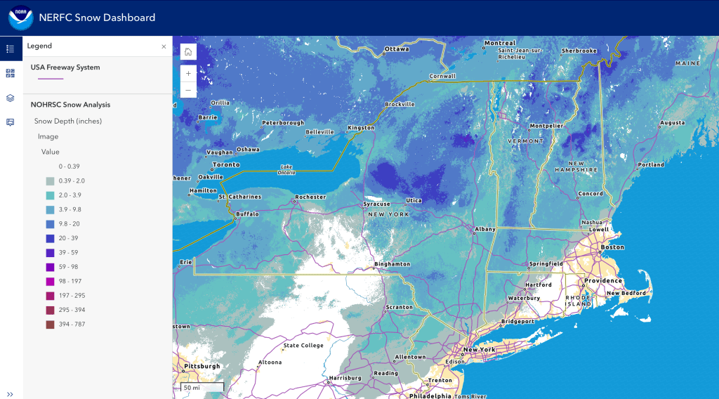
Hit up ‘State of the touring centers‘ or in the menu above for reported conditions as of today. Snow depth graphic below:
Forecast
Recap: From Friday evening through this morning, colder air brought in from the northwest by a strong low to our northwest in Canada interacted with a moisture-carrying stream off the coast. What might have fallen as rain in NYC was instead a couple of inches of snow and sleet. Further inland, it was almost all snow. This coastal system is moving northeasterly, and is expected to deliver snow mainly to the interior of Connecticut and Rhode Island and eastern Massachusetts.
Snowfall over the last 24 hours (see graphic below) shows 2-4″ of snow across a broad swath of southern New York and New England, and along the coast all the way to Maine. A certain area of the Catskills around Big Indian or Shandakan received 6-8″ of snow.

[Update Jan. 19] as bullet points for convenience:
- Very cold on Tuesday 1/20, with lake effect snow showers for the far north.
- Warmer on Wednesday, with downstate NYC metro and coastal areas above freezing, so precipitation arriving late Wednesday or Thursday morning could start as rain or wintry mix before changing to snow.
- Cold temps again for the weekend, and a low that appears to track to the south of the region. Any snow coming from this will primarily affect southern areas up through Albany and southern New England, but forecasts are uncertain. More lake effect snow expected in the Tug Hill and far north should bering some referesh of snow up there.
By Tuesday a stream of cold air will be drawn into our region by a stable low sitting in Canada, and lake effect snow will create snow showers across central and upstate New York, and northern Vermont. Stronger winds with gusts of 24-30mph will accompany the change in weather, and then abate somewhat for a couple of days.

Slightly warmer temsp midweek will give way to another cold front on Thursday. Of greater interest could be a system that will generate snow showers broadly across the northeast staring late Wednesday and lasting into Thursday just ahead of it. Winds and wind gusts will again pick up during this change, mainly in the mountains.
Even colder temps may be in store for us for next weekend. Another, longer-lasting system may bring snow showers across the northeast as well. Obviously this is far enough out that things can change.
| Date | Northern NY VT NH mtns | Northern lowlands | Hudson Highlands to NYC metro |
| Mo 1/19 (MLK day) | Single digits to teens | Mid to upper 20s | Low 30s |
| Tu 1/20 | Below zero to single digits | Teens | Teens to low 20s |
| We 1/21 | Single digits to teens | Mid 20s | Upper 20s to mid 30s |
| Th 1/22 | Teens | Upper 20s to low 30s | Mid to upper 30s |
| Fr 1/23 | Single digits | Teens to low 20s | Upper 20s to low 30s |
| Sa 1/24 | Single digits | Teens to mid 20s | 30s |
